Content from all Earth science data sites are migrating into this site from now until end of 2026. Not all NASA Earth science data will appear across the site until then. Thank you for your patience as we make this transition.
Read about the Web Unification Project
Sentinel-1 C-SAR Resources
Earthdata resources for users working with NASA’s Sentinel-1 C-band Synthetic Aperture Radar data include tutorials and other learning resources, news announcements such as instrument updates and data releases, user guides and related documents, and frequently asked questions.
Sentinel-1 C-SAR Learning Resources

Learn how to create and unwrap an interferogram with GMT5SAR script in the cloud for Windows in NASA’s Alaska Satellite Facility Distributed Active Archive Center (ASF DAAC) tutorial.
Tutorial

Learn to create and unwrap an interferogram with GMT5SAR script in the cloud — OS X in this data recipe from NASA’s Alaska Satellite Facility Distributed Active Archive Center (ASF DAAC).
Data Recipe

Learn how to create a deformation map from unwrapped interferograms in this data recipe from NASA’s Alaska Satellite Facility Distributed Active Archive Center (ASF DAAC).
Data Recipe
Order Sentinel-1 interferometric synthetic aperture radar (InSAR) products On Demand from NASA’s Alaska Satellite Facility Distributed Active Archive Center (ASF DAAC) for individual SLC bursts.
StoryMap
Learn how to phase unwrap an interferogram in this data recipe from NASA’s Alaska Satellite Facility Distributed Active Archive Center (ASF DAAC).
Data Recipe

Learn how to use the CloudFormation Template to automate the processing of Sentinel-1 radiometrically terrain-corrected (RTC) products.
Data Recipe
Learn how to batch-process one or more radiometric terrain correction (RTC) images using the Sentinel-1 Toolbox.
Data Recipe
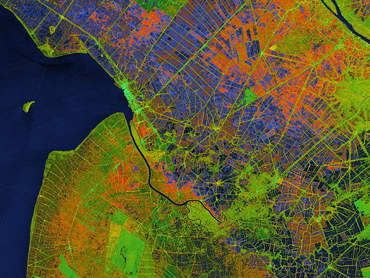
![This image shows Geocoded RGB Composite Image of Bucharest, Romania in Google Earth. Credit: ASF DAAC 2017; Contains modified Copernicus Sentinel data [2015] processed by ESA](https://earthdata.nasa.gov/s3fs-public/styles/hds_generic_card/public/2024-09/rgb-resulting-image.jpg?VersionId=g3VhlSo.o6e0osh0mRBH1pszhjJKgbgX&itok=7pmIc5-N)
In this data recipe, you will learn how to create a coherence-based multi-temporal color composite of land coverage using the European Space Agency (ESA) Sentinel-1 Toolbox.
Data Recipe
SHOWING 8 OF 43

The radiometric terrain corrected synthetic aperture radar data are NASA’s first to meet Committee on Earth Observations Satellites specifications.
News

A summary of datasets, products, and resources released by NASA’s Distributed Active Archive Centers (DAACs) in October 2024.
News

Sentinel-1 synthetic aperture radar (SAR) data are used to create maps of surface water extent for research, planning, and disaster response.
News

A summary of datasets, products, and resources released by NASA's Distributed Active Archive Centers (DAACs) in July 2024.
News
SHOWING 4 OF 33
Frequently Asked Questions
Earthdata Forum
Our online forum provides a space for users to browse thousands of FAQs about research needs, data, and data applications. You can also submit new questions for our experts to answer.
Submit Questions to Earthdata Forumand View Expert Responses