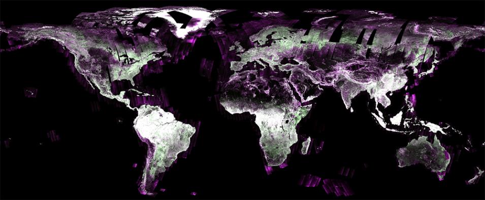
A set of NASA's premier synthetic aperture radar (SAR) products now follow new metadata standards to make them "plug-and-playable" with Geographic Information Systems (GIS), related software, and optical imagery. The compliant datasets are the radiometric terrain corrected (RTC) products created by the Observational Products for End-Users from Remote Sensing Analysis (OPERA) project and derived cooperatively from the ESA's (European Space Agency) Copernicus Sentinel-1 satellite constellation.
The standards the RTC products now comply with are the Committee on Earth Observations Satellites Analysis Ready Data’s (CEOS-ARD) normalized radar backscatter specifications v5.5 (NRB 5.5). This marks the first NASA SAR data collection to be certified as CEOS-ARD compliant.
"The OPERA products are ready for GIS analysis out of the box—no further processing is necessary to get meaningful scientific information from them, making them one of the most accessible operationally processed SAR datasets currently available," said Thomas Logan, a senior engineering specialist for the Alaska Satellite Facility Distributed Active Archive Center (ASF DAAC), which houses Sentinel-1 and OPERA SAR datasets. Logan, who led the certification effort, is also a member of the CEOS-ARD team that developed the NRB 5.5 specifications.
"Another key point is the certified SAR-RTC products allow researchers to treat the radar data like optical imagery, which means they can seamlessly analyze optical imagery from platforms such as Landsat and Sentinel-2 with data from SAR instruments," said Dr. Gerald Bawden, the program scientist at NASA headquarters responsible for OPERA.
Optical imagery provides information about the color and appearance of land and living surfaces, which researchers can use to determine what is present in those areas as well as some details on the general conditions. Radar data can reveal the surface roughness of the land, its soil and vegetation moisture content, and vegetation density. Radar data can also be used to determine water surface conditions such as waviness and identify water inundation into inland areas and beneath forest canopies.
Now that OPERA's SAR-RTC products are NRB 5.5 compliant, complementary SAR imagery are as easy to use as optical data.
"This is a major contribution because people no longer need to be a radar scientist to take advantage of the wealth of information in radar imagery," said Bawden. "The RTC products remove the barriers and make it possible for researchers, decision-makers, and hobbyist alike to directly view and analyze the imagery."
Logan collaborated with OPERA Project Manager Dr. David Bekaert and Algorithm Development Lead Dr. Heresh Fattahi, both from NASA's Jet Propulsion Laboratory (JPL) in Southern California, to complete the RTC certification process. The underlying RTC algorithm was developed by JPL’s Dr. Gustavo Shiroma as part of the NASA-Indian Space Research Organisation (ISRO) SAR (NISAR) project. Shiroma adapted the NISAR algorithm for Sentinel-1 and made it CEOS compliant.
"By achieving CEOS compliance for our radiometric terrain corrected radar products, we ensure that the usability is improved by meeting standards set by the international remote sensing community," said Bekaert.
Plug-and-Playing Well With Others
When visualized, RTC data are essentially grayscale or false-color images of an area made from Sentinel-1's all-weather, day-and-night radar observations. The images from Sentinel-1 and other SAR platforms are incredibly detailed, and over time experts have been steadily improving their ability to quickly create them.
"When I started working with SAR images 30 years ago, it took a day to make one RTC image—and you had to modify the data and metadata to make it work with your software," said Logan. "Today, you can make thousands of images in just 15 minutes."
Even now, a lot of datasets and their descriptive metadata are still frequently formatted in ways unique to the researcher or institution. This slows or hinders the broader use of the datasets because they require many hours of modification by anyone else who wants to use them. It is therefore very important to standardize datasets for workflow efficiency and file interoperability.
This is why the international community and space agencies jointly developed the CEOS-ARD NRB 5.5 specifications, which require data engineers to modify SAR datasets to include information for roughly 40 specific metadata fields as well as meet other guidelines, such as formatting images as location-information-embedded GeoTIFFs. Doing so makes the products immediately compatible with software built to recognize and interpret files formatted for the specification. NRB 5.5-compliant products also offer the advantage of being able to be used together regardless of their production sources.
The SAR-RTC products are not only valuable on their own, but they are also the building blocks for two new NASA products: Global Surface Water Extent and Global Disturbance. Both of these new products require uniformly processed imagery to detect both water and land surface disturbances.
Logan said the process to modify and review the SAR-RTC products took about a year to complete and involved multiple iterations. Now that it's done, he hopes it will make the open data more accessible to more people than ever, such as city planners, disaster response professionals, and others across a variety of fields.
For next steps, Logan says the CEOS-ARD team are now working on developing specifications for formatting displacement products, which are SAR data that can be used for interferometric timeseries analysis. Additionally, the NISAR mission and its powerful next-generation, terrain-mapping radar is expected to launch in early 2025 and will be another high-quality, free and open source of SAR-RTC products.
