The International Association of Geodesy (IAG)
The International Association of Geodesy (IAG) is a scientific organization in the field of geodesy. The mission of the IAG is the advancement of geodesy and thus the association promotes scientific cooperation and research in geodesy on a global scale and contributes to it through its various research bodies. It is an active member of the International Association of Geodesy and Geophysics (IUGG) which itself is a member of the International Council for Science (ICSU). Key components of the IAG are its Services. In particular, the geometric services are dedicated to providing data and products relevant for geodesy and broader scientific applications:
Services function as cooperating federations dedicated to a particular type of data. They provide data and products on an operational basis to geodesy analysts as well as a broader scientific community. The services are examples of a successful model of community management where they develop standards, are self-regulating, monitor performance, and define and deliver products using pre-determined schedules. The IAG services are a excellent example of successful operation through cooperation of many international organizations who leverage their respective limited resources to all levels of service functionality.
The CDDIS is the principle data center supporting four geometric services created under the IAG and make up the primary user community for CDDIS archive.
Space Geodesy Project (SGP)
NASA's Space Geodesy Project (SGP) is an initiative that started in the fall of 2011. SGP is part of the Earth Science Decadal and the National Research Council study "Precise Geodetic Infrastructure." It is a Goddard/JPL partnership with participation from the Smithsonian Astrophysical Observatory and the University of Maryland.
The long-range goal of the Space Geodesy Project is to build, deploy and operate a next generation NASA Space Geodetic Network (NSGN) of integrated, multi-technique next generation space geodetic observing systems, along with a system that provides for accurate vector ties between them. This new NSGN will serve as NASA’s core contribution to a global network designed to produce the higher quality observational data required to maintain the Terrestrial Reference Frame and provide other data necessary for fully realizing the measurement potential of the current and coming generation of Earth Observing spacecraft.
The primary goals of the SGP are to:
- Contribute to the maintenance and improvement of a stable Terrestrial Reference Frame (TRF) that meets the needs of NASA's Earth orbiting missions, Earth Surface and Interior Focus Area, and deep space navigation
- Contribute to measurements of Earth orientation parameters (EOP) that meet the needs of NASA's Earth orbiting missions, Earth Surface and Interior Focus Area, and deep space navigation
- Contribute to determining accurate precision orbits to meet the needs of NASA's geodetic, Earth observation, navigation and space science missions
From: SGP website
International Earth Rotation and Reference Systems Service (IERS)
The International Earth Rotation and Reference Systems Service (IERS) was created in 1988 by the International Union of Geodesy and Geophysics (IUGG) and the International Astronomical Union (IAU). It replaced the Earth rotation section of the Bureau International de l'Heure (BIH), and the International Polar Motion Service (IPMS). It is a member of the Federation of Astronomical and Geophysical Data Analysis Services.
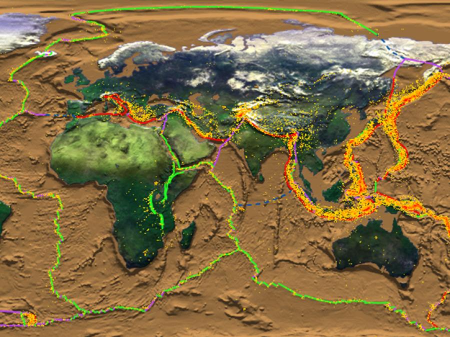
According to its Terms of Reference, the mission of the IERS is to provide timely and accurate data on the Earth's rotation for current use and long-term studies. For this purpose it has established and maintains an international terrestrial reference frame and an international celestial reference frame and it regularly monitors the relative motion of these two frames by analysing observational data from a variety of techniques, including Very Long Baseline Interferometry (VLBI), Lunar Laser Ranging (LLR) and satellite-geodetic techniques such as Global Navigation Satellite Systems (GNSS), Satellite Laser Ranging (SLR), and Doppler Orbitography and Radio-Positioning by Integrated Satellite (DORIS).
The IERS techniques have strengths that are used in a complementary way, keeping enough redundancy for ensuring the permanence of the service over decades and maintaining close operational interaction with other global astronomical and geophysical programs. The maintenance of the consistency and accuracy of IERS products requires a careful organisation and management of the contributions of the major techniques used in space navigation, space geodesy and astrometry.
The IERS is an interdisciplinary service that maintains key connections between astronomy, geodesy and geophysics.
From: IERS web site
Global Geodetic Observing System (GGOS)
In mid-2003, the IAG established the Global Geodetic Observing System (GGOS) as a project to foster cooperation among the geometric services of the IAG and to promote outreach and education to a broad user community on the importance of the geodetic infrastructure to many Earth science applications. GGOS, a component of the IAG, works to integrate the geodetic techniques to ensure long-term monitoring of Earth processes, including global change research. Distribution of data and products for the generation of GGOS combination products will be accomplished through the data flow paths developed by the IAG services forming the underlying structure of GGOS. Access to data and products generated by these services will continue to be provided through the services, either directly or via a GGOS portal. This portal will facilitate access to GGOS products and provide a way to view the underlying, dedicated information systems developed by the IAG’s contributing services.
The CDDIS supports GGOS as an essential archive for the geometric services and will contribute to the GGOS portal by implementing systems to provide uniform access to a combined set of geodetic services’ information as well as technique-specific information systems.
From: GGOS web site
Earth Observing System Data and Information System (EOSDIS)
In late 2007, funding support for the CDDIS transitioned from the science research area within NASA to the Earth Observing System Data and Information System (EOSDIS). EOSDIS is a key core capability in NASA's Earth Science Data Systems Program. EOSDIS provides end-to-end capabilities for managing NASA’s Earth science data from various sources – satellites, aircraft, field measurements, and other programs. EOSDIS is responsible for the processing, archiving, and distribution of Earth science data sets, providing tools to facilitate use of these data, and ensuring that these data are available to the public to study Earth processes from space in order to meet the needs of the global community. In addition to managing the science systems, EOSDIS supports 12 Distributed Active Archive Centers (DAACs) in the U.S., each of which serves a specific Earth system science discipline. As one of these EOSDIS data centers, the CDDIS cooperates with other groups in support of NASA’s Earth science goals. This activity includes implementation of metadata standards that will eventually permit discovery of CDDIS archive content by researchers outside the existing user base. Thus, the CDDIS will have the opportunity to promote use of its data and products to a broader scientific community.