NASA's Earth Science Data Systems (ESDS) Program oversees the life cycle of NASA’s Earth science data—from acquisition through processing and distribution. The primary goal of ESDS is to maximize the scientific return from NASA's missions and experiments for research and applied scientists, decision makers, and society at large.

ESDS data system and science products continuously evolve through a combination of competitive awards and sustained and strategic investments in open data, international and interagency partnerships, and a set of standards that ensure consistency and interoperability. Since 1994, NASA Earth science data have been free and open to all users for any purpose, and since 2015, all data systems software developed through NASA research and technology awards have been made available to the public as Open Source Software (OSS).

ESDS falls within the purview of the agency's Earth Science Division (ESD), under the Science Mission Directorate (SMD) at NASA Headquarters.
Vision and Goals

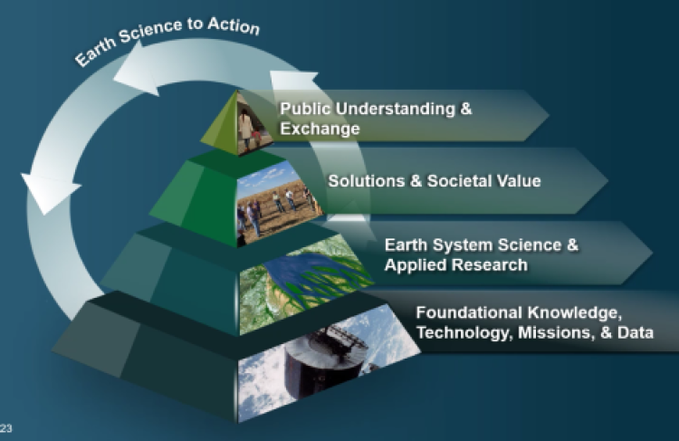
Our vision is to make NASA's free and open Earth science data interactive, interoperable, and accessible for research and societal benefit both today and tomorrow.

Image
open science

Our responsibilities:

  • Process instrument data to create Earth System Data Records (ESDRs)
  • Actively manage NASA’s Earth science data as a national asset
  • Uphold NASA’s policy of free, full, and open sharing of all data, tools, and ancillary information for all users
  • Engage members of the Earth science community in the evolution of data systems
  • Develop data system capabilities optimized to support rigorous science investigations and the unique needs of various scientific disciplines

Our goals:

  • Set the standard for efficient production and stewardship of science-quality data
  • Advance open science data systems for the next generation of missions, data sources, and user needs
  • Lead research and development of technology for management and analysis of complex Earth science data
  • Leverage the diversity of global Earth science communities to advance open science

ESDS aligns with Goal 1 of NASA's 2018 Strategic Plan, particularly Objective 1.1 "Understand the Sun, Earth, Solar System, and Universe." The ESDS Program primarily accomplishes this goal via NASA's Earth Observing System Data and Information System (EOSDIS), which has provided end-to-end capabilities for managing NASA’s Earth science data since 1994.


Program Components

Image
quote

ESDS works to achieve its goals by means of several component projects, programs, and partnerships:

Data System Evolution (DSE)
The Data System Evolution (DSE) element of ESDS funds various research opportunities, as well as interagency initiatives and the promotion of data and service interoperability through development and implementation of standards. DSE is composed of support for the Interagency Implementation and Advanced Concepts Team (IMPACT) activity, competitive programs, and the development of long-term data records needed by NASA scientists.

  • Competitive programs
    Competitive programs focus on the development of new Earth science data products and innovative technology. Current programs include: Advancing Collaborative Connections for Earth System Science (ACCESS), Citizen Science for Earth Systems Program (CSESP), and Making Earth System Data Records for Use in Research Environments (MEaSUREs).
  • Earth Science Data Systems Geographic Information Systems Team (EGIST)
    NASA's EGIST was created to enable the appropriate use and adoption of geographic information system (GIS) technology in support of Earth science research and applied science for EOSDIS data.
  • Interagency Implementation and Advanced Concepts Team (IMPACT)
    IMPACT builds partnerships with other Federal agencies, the applications community, decision makers, non-governmental organizations (NGOs), and other organizations to encourage the adoption of NASA Earth observation data into workflows and operational models.
  • Sea Level Change Portal
    Science portals comprehensively address and communicate information about a specific topic in collaboration with research and analysis programs. The first of these, the Sea Level Change Portal, addresses the topic of sea level rise.

Multi-Mission Data Processing System Study
With NASA's Earth science data archive on the verge of exponential growth, ESDS is developing a data architecture to ensure that NASA Earth science data from multiple missions are available as early in the mission process as possible and are finable, accessible, interoperable, and reusable (FAIR).

Earth Science Data and Information System (ESDIS) Project
The ESDIS Project manages EOSDIS operations, including Science Investigator-led Processing Systems (SIPS), Distributed Active Archive Centers (DAACs), and the Land, Atmosphere Near real-time Capability for EO (LANCE).

Earth Information System
NASA's Earth Information System (EIS) project provides a global analysis framework that integrates information and data from various satellite missions, model platforms, and research programs to advance our understanding of the complex systems of our planet.

Commercial Smallsat Data Acquisition (CSDA) Program
CSDA was established to identify, evaluate, and acquire remote sensing imagery and data that support NASA’s Earth science research and application activities.

Harmonized Landsat and Sentinel-2 (HLS)
The HLS project takes input data from sensors aboard the joint NASA/USGS Landsat 8 and Landsat 9 satellites and the ESA (European Space Agency) Sentinel-2A and Sentinel-2B satellites to generate a harmonized, analysis-ready, 30-meter resolution surface reflectance data product with observations every two to three days.

The Multi-Mission Algorithm and Analysis Platform (MAAP)
MAAP is a collaborative project between NASA and ESA designed to support aboveground biomass research.

Earth Science Data System Working Groups (ESDSWG)
ESDSWG focuses on the exploration and development of recommendations derived from pertinent community insights of NASA's heterogeneous and distributed Earth science data systems.

Standards and Interoperability Coordination and Development
ESDS promotes data and service interoperability through development and implementation of standards.

Visualization, Exploration, and Data Analysis (VEDA) Project
VEDA consolidates GIS delivery mechanisms, processing platforms, analysis services, and visualization tools and provides an ecosystem of open tools for addressing Earth science research and application needs.

Learn more about ESDS Program components.

Last Updated