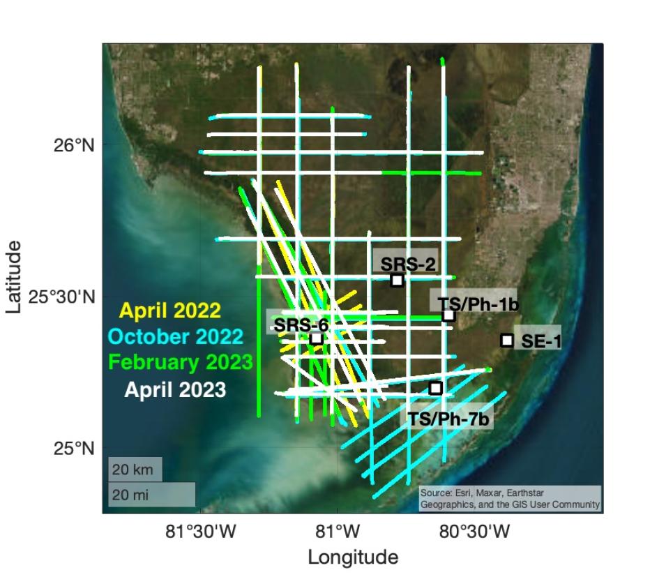
NASA's ORNL DAAC released Version 1 of the BlueFlux Airborne Trace Gases, Fluxes, and Mixing Ratios, Southern Florida, 2022-2023 dataset. The objective of the BlueFlux campaign was to measure greenhouse gases in Florida's mangrove ecosystems. This dataset includes airborne in-situ measurements of greenhouse gas mixing ratios, meteorological parameters, and fluxes (carbon dioxide, methane, latent heat fluxes, friction velocity, and convective velocity scale) calculated with wavelet transforms.
Flights occurred April 19 to 26, 2022, October 14 to 20, 2022, February 5 to 13, 2023, and April 13 to 19, 2023, and flight lines spanned southern Florida's Everglades National Park and Big Cypress National Preserve.
Access BlueFlux data and more information
Gridded Carbon Dioxide and Methane Flux Estimates for Pan-Arctic and Boreal Regions Dataset Available
Version 1 of the Gridded Carbon Dioxide and Methane Flux Estimates for pan-Arctic and Boreal Regions, 2003-2015 dataset is now available. The dataset provides gridded estimates of gross primary productivity (GPP), ecosystem respiration (Reco), net ecosystem carbon dioxide exchange, and methane emissions from tundra and boreal wetland soils across the pan-Arctic and Boreal zone at 1-km spatial resolution. The data were produced through simulations of the Arctic Terrestrial Carbon Flux Model, are provided at the daily time step for the years 2003 to 2015, and are provided in netCDF and comma-separated values (CSV) formats.
Access the Gridded Carbon Dioxide and Methane Flux Extimates dataset and more information
Geological Earth Mapping Experiment (GEMx), California-Arizona Dataset Released
The Geological Earth Mapping Experiment (GEMx), California-Arizona, Summer 2023 Version 1 dataset created from data acquired by the MODIS/Advanced Spaceborne Thermal Emission and Reflection Radiometer (ASTER) Airborne Simulator (MASTER) instrument is now available. This dataset includes Level 1B and Level 2 data. Spectral data were collected during 13 flights aboard a NASA ER-2 research aircraft over California, Oregon, Nevada, and Arizona from April 25, 2023, to September 26, 2023. Level 1B files are in HDF4 format; Level 2 products are provided in ENVI and KMZ formats. The dataset also includes the flight path, spectral band information, instrument configuration, ancillary notes, summary information for each flight, and browse images derived from each Level 1B data file.
Access the GEMx MASTER dataset and more information
Western Diversity Time Series Campaign, Spring 2023 Version 1 Dataset Available
ORNL DAAC released the Western Diversity Time Series (WDTS) campaign, Spring 2023 Version 1 dataset, which includes Level 1B and Level 2 data products from the MASTER instrument. The spectral data were collected as part of the WDTS airborne campaign during 12 flights aboard a NASA ER-2 research aircraft over California and Nevada from March 31, 2023, to May 2, 2023. Level 1B files are available in HDF4 format; Level 2 products are provided in ENVI and KMZ formats. The dataset also includes the flight path, spectral band information, instrument configuration, ancillary notes, summary information for each flight, and browse images derived from each Level 1B data file.
Access the WDTS MASTER dataset and more information
Satellite-Derived Forest Extent Likelihood Map for Mexico Version 1 Dataset Released
The Satellite-Derived Forest Extent Likelihood Map for Mexico Version 1 dataset is now available. This dataset provides a comparison of forest extent agreement from seven remote sensing-based products across the country—the ESA (European Space Agency) 2020 Land Cover Map for Mexico, Globeland30 2020, Commission for Environmental Cooperation 2015 Land Cover Map, Impact Observatory 2020 Land Cover Map, NAIP Trained Mean Percent Cover Map, Global Land Analysis and Discovery Global 2010 Tree Cover, and Global Forest Cover Change Tree Cover 30 Meter Global. All products include data at 10- to 30-meter resolution and represent the state of forest or tree cover from 2010 to 2020. The combined agreement map documents forest cover for each satellite-derived product at 30-meter resolution across the country. Data are in cloud optimized GeoTIFF format and cover the period 2010 to 2020. A shapefile is included that outlines Mexico mainland areas.
Access the Satellite-Derived Forest Extent Likelihood Map for Mexico and more information
New North America Surface Soil Moisture Dataset Available
ORNL DAAC released Version 1 of the North America Soil Moisture Dataset Derived from Time-Specific Adaptable Machine Learning Models (NASMo-TiAM) 250 Meter 16-day North America Surface Soil Moisture dataset. This dataset holds gridded estimates of surface soil moisture (0 to 5 cm depth) at a spatial resolution of 250 meters over 16-day intervals from mid-2002 to December 2020 for North America. The model used random forests to downscale coarse-resolution soil moisture estimates (0.25 degrees) from the ESA (European Space Agency) Climate Change Initiative (ESA CCI) based on their correlation with a set of static (terrain parameters, bulk density) and dynamic covariates (Normalized Difference Vegetation Index, land surface temperature). The data are provided in cloud optimized GeoTIFF format.
Access the NASMo-TiAM soil moisture dataset and more information
Arctic Boreal Annual Burned Area, Circumpolar Boreal Forest and Tundra Dataset Released
Version 2 of the Arctic Boreal Annual Burned Area, Circumpolar Boreal Forest and Tundra 2002-2022 dataset is now available This product provides annual cumulative end-of-season burned area in circumpolar boreal forests and tundra for the years 2002 to 2022. The spatial domain is circumpolar regions above 50° north latitude and the data are provided in cloud optimized GeoTIFF format with 463-meter resolution.
Access the Arctic Boreal Annual Burned Area dataset and more information
Global Daily Gross Primary Production Dataset Available
The Global MODIS and FLUXNET-derived Daily Gross Primary Production, Version 2 dataset provides global gridded daily estimates of gross primary production (GPP) and uncertainties at 0.05° resolution for the period covering March 1, 2000, to near present.
Access Global MODIS and FLUXNET data and more information
Photosynthetic and Leaf Traits, Santa Barbara County, Dataset Now Available
Version 1 of the Photosynthetic and Leaf Traits, Santa Barbara County, 2022 dataset from the NASA Surface Biology and Geology (SBG) High Frequency Time series (SHIFT) campaign is now available. This dataset provides leaf images and measurements of leaf traits (area, wet weight, dry weight, leaf mass per area, leaf water content) and leaf pigments (chlorophyll) and species information as sampled from meadows, shrubs, and trees in Santa Barbara, California.
Samples were collected from plots within the Dangermond Preserve, Sedgwick Reserve, and Carpinteria Salt Marsh Reserve from February 23, 2022, to September 27, 2022. The associated data package contains image scans used for the leaf area calculations as well as Python processing code used to calculate the area. A CSV-formatted file includes plot-level leaf area, wet weight, leaf mass area, leaf water content, chlorophyll fluorescence ratio, and chlorophyll content.
Access the Photosynthetic and Leaf Traits, Santa Barbara County dataset and more information
Global Vegetation Height Metrics Dataset Released


