VIIRS Filenames
VIIRS filenames for Level 2G, Level 3, and Level 4 products follow a naming convention which provides useful information regarding the specific product.
In this example for a swath product, the filename VJ121.A2021101.0054.002.2021102014936.nc indicates:
- VJ121: Product Short Name
- .A2021101: Acquisition year and Julian day (AYYYYDDD)
- .0054: Coordinated Universal Time (HHMM)
- .002: Collection Version
- .2021102014936: Production year, Julian day, and time (YYYYDDDHHMMSS)
- .nc: Data Format (NetCDF4)
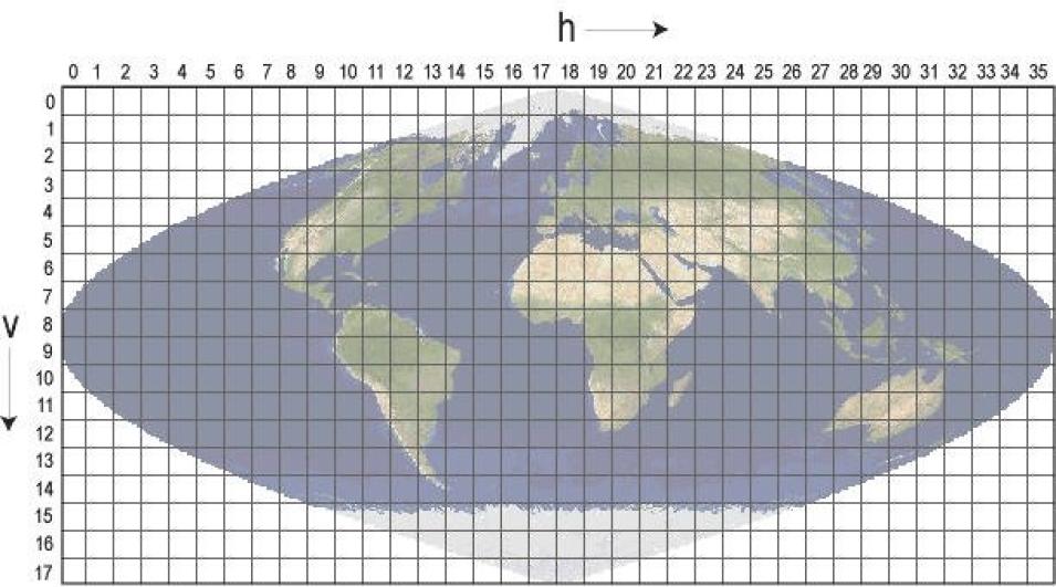
In this example for a tiled product, the filename VNP09GA.A2019004.h15v05.002.2020244220120.h5 indicates:
- VNP09GA: Product Short Name
- .A2019004: Acquisition year and Julian day (AYYYYDDD)
- .h15v05: Tile Identifier (horizontalXXverticalYY) (see VIIRS Tiling System below)
- .002: Collection Version
- .2020244220120: Production year, Julian day, and time (YYYYDDDHHMMSS)
- .h5: Data Format (HDF-EOS5)
In this example for a Climate Modeling Grid (CMG) product, the filename VNP09CMG.A2019009.002.2021148200733.h5 indicates:
- VNP09CMG: Product Short Name
- .A2019009: Acquisition year and Julian day (AYYYYDDD)
- .002: Collection Version
- .2021148200733: Production year, Julian day, and time (YYYYDDDHHMMSS)
- .h5: Data Format (HDF-EOS5)
In this example for a combined VIIRS/NPP+JPSS1 product, the filename VCD19A1CMG.A2021240.002.2025188150851.h5 indicates:
- VCD19A1CMG: Product Short Name
- .A2021240: Acquisition year and Julian day (AYYYYDDD)
- .002: Collection Version
- .2025188150851: Production year, Julian day, and time (YYYYDDDHHMMSS)
- .h5: Data Format (HDF-EOS5)
VIIRS Product Long Name
A VIIRS product long name contains information about the data including the sensor, satellite, collection name and more. One example of a VIIRS Product Long Name is VIIRS/NPP Surface Reflectance 8-Day L3 Global 500m SIN Grid V001. Note that both Version 1 and Version 2 follow the same long name format and only the version number (i.e. V001) will change (i.e. V002).
For example, all products belonging to the VIIRS/NPP Surface Reflectance 8-Day L3 Global 500m SIN Grid V001 collection have the following characteristics:
- VIIRS/NPP: Instrument/Satellite
- Surface Reflectance: Geophysical Parameter
- 8-Day: Temporal Resolution
- L3: Processing Level
- Global: Global Coverage
- 500m: Spatial Resolution
- SIN Grid: Sinusoidal Grid
- V001: Collection Version
For example, all products belonging to the VIIRS/JPSS1 Land Surface Temperature and Emissivity 6-Min L2 Swath 750m V002 collection have the following characteristics:
- VIIRS/JPSS1: Instruments/Satellites
- Land Surface Temperature and Emissivity: Geophysical Parameter
- 6-Min: Temporal Resolution
- L2: Processing Level
- Swath: Swath Coverage
- 750m: Spatial Resolution
- V002: Collection Version
For example, all products belonging to the combined VIIRS/NPP+JPSS1 BRDF Model Parameters Daily L3 Global 750m RSIN Grid V002 collection have the following characteristics:
- VIIRS/NPP+JPSS1: Instrument/Satellite
- BRDF Model Parameters: Geophysical Parameter
- Daily: Temporal Resolution
- L3: Processing Level
- Global: Global Coverage
- 500m: Spatial Resolution
- RSIN Grid: Rotated Sinusoidal Grid
- V002: Collection Version


