We are in the process of migrating all NASA Earth science data sites into Earthdata from now until end of 2026. Not all NASA Earth science data and resources will appear here until then. Thank you for your patience as we make this transition.
Read about the Web Unification Project
NASA Earth Science Data Roundup: January 2024
A summary of datasets, products, and resources released by NASA’s Distributed Active Archive Centers (DAACs) in December 2023.
Caption
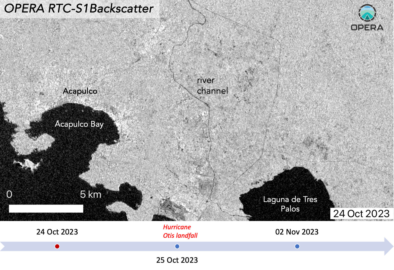
On October 25, 2023, Hurricane Otis made landfall near Acapulco, Mexico, causing widespread damage and flooding. This animation shows the OPERA RTC-S1 backscatter before landfall (October 24, 2023) and after landfall (November 2, 2023). The data show a clear increase in water extent between the October 24 image and the November 2 image. (Note: Click on the image to start animation). Credit: OPERA/JPL.
Two new data products from the NASA Jet Propulsion Laboratory's (JPL) Observational Products for End-Users from Remote Sensing Analysis (OPERA) project are available from NASA's ASF DAAC. These high-level synthetic aperture radar (SAR) products are intended to address the Earth science community's need for free, analysis-ready, low-latency space-based observations.
SAR data typically require additional processing steps before they are useful for Earth science applications and workflows. Such processing is often difficult, expensive, and time-consuming. The new Level 2 Radiometric Terrain Corrected SAR Backscatter (RTC-S1) and Coregistered Single-Look Complex (CSLC-S1) products eliminate these hurdles by providing users with data that are already processed and ready for immediate applications.
OPERA Level 2 SAR Products data access and more information
NISAR Sample Data Now Available
The NASA-ISRO (Indian Space Research Organization) Synthetic Aperture Radar (NISAR) mission project team has created sample products using JAXA (Japan Aerospace Exploration Agency) Advanced Land Observing Satellite (ALOS-1) Phased Array L-band Synthetic Aperture Radar (PALSAR) data as a surrogate for NISAR. The sample covers the full suite of planned products, from Level 0 raw data to Level 1 and Level 2 products. These data cover a smaller area than a NISAR frame; however, the format and metadata content are fully compatible with the data NISAR will produce after entering its science phase. This allows users to prepare their analysis tools well in advance of operations.
Atmospheric Science Data Center (ASDC)
Data from STRAT Campaign Released
NASA's ASDC released the data for the Stratospheric Tracers of Atmospheric Transport (STRAT) campaign. STRAT was conducted by NASA from May 1995 to February 1996 with the primary goals of studying the transport of gases and aerosols in the stratosphere and characterizing atmospheric photochemistry. To accomplish its objectives, the STRAT team conducted various surface-based remote sensing and in-situ measurements. NASA's ER-2 aircraft was deployed along with ozone sondes and radiosondes just below the tropopause in the Northern Hemisphere. Nine collections are publicly available via Earthdata Search and the ASDC's Direct Data Download.
STRAT Campaign data access and more information
Goddard Earth Sciences Data and Information Services Center (GES DISC)
NOAA-20 OMPS Product Released
Image

Image Caption
Screenshot form an animation of NOAA-20 OMPS Nadir Mapper data showing total column sulfur dioxide from the eruption of the Raikoke volcano in the Kuril Islands chain in the Sea of Okhotsk on July 1, 2019. Reds and yellows indicate higher sulfur dioxide concentrations. Credit: NASA's GES DISC.
NASA's GES DISC released Version 1 of a new NOAA-20 Ozone Mapping and Profiling Suite (OMPS) sulfur dioxide (SO2) data collection. This Level 2 orbital swath data product—OMPS-N20 NM PCA SO2 Step 1—contains retrieved total column SO2 measured by the OMPS Nadir-Mapper sensor aboard the NOAA-20 satellite.
Each granule (file) contains data from the daylight portion for a single orbit, or about 50 minutes. Spatial coverage is global (-90º to 90º latitude), and there are about 14 orbits per day with a swath width of 2,600 kilometers (km) each.
The data files are written using NetCDF4 and the product is based on the NASA Goddard Space Flight Center principal component analysis (PCA) spectral fitting algorithm, enabling a consistent data record with NASA's standard SO2 products from the Ozone Monitoring Instrument (OMI) and the Suomi National Polar-orbiting Partnership (Suomi NPP) OMPS instruments, which are based on the same algorithm.
NOAA-20 OMPS Product data access and more information
TROPESS AIRS-Aqua Reanalysis Products Now Available
GES DISC released Atmospheric Infrared Sounder (AIRS)-Aqua Level 2 Reanalysis Summary Version 1 products for methane (CH4), deuterated water vapor (HDO), ozone (O3), and carbon monoxide (CO) from the TRopospheric Ozone and its Precursors from Earth System Sounding (TROPESS) project.
The TROPESS project uses an optimal estimation algorithm, known as the MUlti-SpEctra, MUlti-SpEcies, Multi-SEnsors (MUSES) algorithm. TROPESS builds upon the success of the Tropospheric Emission Spectrometer (TES) by using an optimal estimation algorithm based on the TES algorithm.
The data coverage time period of the Level 2 TROPESS AIRS-Aqua products is September 1, 2002, to March 31, 2020. The input data used to generate these TROPESS data products is the AIRS Level 1B Infrared Geolocated and Calibrated Radiances V005 data product. The data files are written in NetCDF4 and each file contains one day of data. The data have a spatial resolution of 13.5 km and are reported at a range of 14 to 26 vertical levels (depending on gas species) from the surface to 0.1 hectoPascals (hPa).
TROPESS AIRS-Aqua Reanalysis Products data access and more information
TROPESS CrIS-SNPP Reanalysis Products Now Available
Image

Image Caption
This visualization of Suomi NPP Cross Track Infrared Sounder (CrIS) data shows the density of global carbon monoxide on April 1, 2021. Red and orange areas indicate regions with the highest densities; blue areas indicate the lowest. Credit: TROPESS project.
GES DISC has also released new TROPESS Cross-track Infrared Sounder (CrIS)-Suomi NPP Level 2 Reanalysis Summary Version 1 products for CH4, peroxyacetyl nitrate (PAN), HDO, O3, CO, and ammonia (NH3).
The key distinguishing feature of this reanalysis dataset compared to the TROPESS CrIS-Suomi NPP Level 2 Forward Stream data products is the availability of data from the start of the CrIS data record in 2015 to 2022.
TROPESS CrIS-SNPP Reanalysis Products data access and more information
Level 2 Single Field-of-View Sounder Atmospheric Products Released
Level 2 Single Field-of-View Sounder Atmospheric Products (SiFSAP) are now available from NASA's GES DISC. The products are derived from the CrIS and Advanced Technology Microwave Sounder (ATMS) instruments, which are known collectively as the Cross-track Microwave Sounding Suite (CrIMSS), aboard the Suomi NPP satellite.
The SiFSAP Level 2 products contain a variety of geophysical parameters retrieved from infrared/microwave (IR/MW) sounder suite measurements, including profiles of temperature, water vapor, and trace gas species, as well as clouds and surface properties for six minutes of instrument observation at a time. Two different product types are provided for each time: a standard retrieval (RET) file with vertical profiles on a reduced number of levels and a full support (SUP) product with high vertical sampling and with Empirical Orthogonal Functions. (GES DISC recommends using SUP files to capture the full information content of the SiFSAP product and using RET files to get atmospheric temperature and water vapor profile values reported at pressure levels similar to those of mandatory radiosonde pressure levels.)
The Level 2 products are divided into a series of six-minute segments, or granules, with each granule making up one file with 240 granules per day. The data for this collection start on November 2, 2015.
Sounder Atmospheric Products data access and more information
Land Processes DAAC (LP DAAC)
First Global Maps of Surface Minerals in Arid Regions
Data from NASA's Earth Surface Mineral Dust Source Investigation (EMIT) sensor on the International Space Station were used to create the first comprehensive maps of the world's mineral dust-source regions, providing precise locations of 10 key minerals based on how they reflect and absorb light. When winds lift these substances into the air, they either cool or warm the atmosphere and Earth's surface, depending on their composition. Understanding their abundance around the globe will help researchers predict future climate impacts. EMIT data are archived at and distributed by NASA's LP DAAC.
Image

Image Caption
NASA's EMIT produced its first global maps of hematite, goethite, and kaolinite in Earth's dry regions using data from the year ending November 2023. The mission collected billions of measurements of the three minerals and seven others that may affect climate when lofted into the air as dust storms. Credit: NASA/JPL-Caltech.
New LPJ-PROSAIL Product
LP DAAC released a new LPJ-PROSAIL Level 2 Global Simulated Dynamic Surface Reflectance Version 2 data product at a 0.5 degree (~50 kilometer) spatial resolution. LPJ stands for Lund-Potsdam-Jena dynamic global vegetation model; PROSAIL is a radiative transfer model. The Version 2 data were produced using the same algorithm as Version 1 while expanding the temporal range from a single year (2020) to 23 years (2000 to 2022). Each granule contains annual data in monthly increments and the data are provided in five separate NetCDF4 files containing simulated data values for different reflectance angles, including bidirectional (BDR), bi-hemispherical (BHR), hemispherical-directional (HDR), directional-hemispherical (DHR), and directional (DR). These simulated reflectance data were produced to aid in workflow development, algorithm testing, and other activities during the lead-up to future global spaceborne imaging spectroscopy missions such as NASA's Surface Biology and Geology.
Due to the simulated nature of LPJ-PROSAIL data, they should not be used for real-world scientific analyses or conclusions. Rather, these data are meant to support the development of workflows, algorithms, and other instances where global imaging spectroscopy datasets are needed for testing or proof-of-concept applications.
LPJ-PROSAIL data access and more information
National Snow and Ice Data Center DAAC (NSIDC DAAC)
New Greenland Annual Ice Sheet Velocity Mosaics Available
Image

Image Caption
The Greenland Annual Ice Sheet Velocity Mosaics from SAR and Landsat, Version 5 dataset contains annual ice velocity mosaics for the Greenland Ice Sheet posted at a 200-meter resolution. Credit: NASA's NSIDC DAAC.
NASA's NSIDC DAAC released the Making Earth System Data Records for Use in Research Environments (MEaSUREs) Program Greenland Annual Ice Sheet Velocity Mosaics from SAR and Landsat, Version 5 dataset. This dataset, part of the NASA Making Earth System Data Records for Use in Research Environments (MEaSUREs) Program, contains annual ice velocity mosaics for the Greenland Ice Sheet posted at a 200-meter resolution. Velocities are estimated using SAR data from TerraSAR-X/TanDEM-X (TSX/TDX) and Sentinel-1A and -1B, as well as optical imagery from Landsat 8 and 9.
High Mountain Asia Dataset Released
The High Mountain Asia Daily 5-kilometer (km) Downscaled SPEAR Precipitation and Air Temperature Projections, Version 1 dataset is now available. This dataset consists of daily, 5-km resolution projections of precipitation and mean near-surface air temperature for the High Mountain Asia (HMA) region. The data were generated by statistically downscaling the 0.5° resolution model data from the Geophysical Fluid Dynamic Laboratory (GFDL) Seamless System for Prediction and EArth System Research (SPEAR) 30-member ensemble climate model.
High Mountain Asia data access and more information
SMAP Level 1, Level 2, and Level 3 Dataset Updates Released
New versions of Soil Moisture Active Passive (SMAP) Level 1, Level 2, and Level 3 datasets are available. Noteworthy changes to the Level 1 data include a new land/water mask and algorithm modifications to reduce radio frequency interference. The Level 2 and Level 3 products are updated on the basis of this new source data. Coverage is currently available from December 4, 2023, onward. Data since March 31, 2015, will become available as they are reprocessed. Coverage will be continuous after reprocessing is complete.
Multiple LVIS Dataset Updates Available
The Land, Vegetation, and Ice Sensor (LVIS) Classic Level 1B Geolocated Return Energy Waveforms, LVIS Classic Level 2 Geolocated Surface Elevation and Canopy Height Product, and LVIS Level 1A Geotagged Images Version 1 datasets have been updated to include data from the 2023 Gabon campaign. These datasets contain the geolocated return energy waveforms collected by the LVIS airborne scanning laser altimeter, the geolocated surface elevation and canopy height data derived from the lidar waveforms, and the geotagged optical images captured by the Digital Mapping System camera mounted alongside the LVIS sensor. Temporal coverage now spans May 21, 2019, through May 31, 2023. Spatial coverage currently includes parts of Alaska, western Canada, the continental United States, Central America, and western Africa.
Oak Ridge National Laboratory DAAC (ORNL DAAC)
GEDI Level 4B Country-Level Summaries of Aboveground Biomass
Image

Image Caption
This screen capture from the GEDI Level 4B mean aboveground biomass density layer shows the crisscross pattern of GEDI’s laser tracks on Earth's terrestrial surface. Credit: GEDI.
The new GEDI Level 4B (L4B) Country-Level Summaries of Aboveground Biomass dataset from NASA's ORNL DAAC provides country-level estimates of land surface mean aboveground biomass density (AGBD), total aboveground biomass (AGB) stocks, and the associated standard errors of the mean calculated using different versions of the Global Ecosystem Dynamics Investigation (GEDI) L4B product. The product provides gridded (1 km x 1 km) estimates of AGBD within the GEDI orbital extent (51.6º N to 51.6º S). For comparison purposes, this dataset also includes national-scale National Forest Inventory estimates of AGBD from the 2020 Global Forest Resources Assessment (FRA) published by the United Nations Food and Agriculture Organization (FAO). The data are provided in comma-separated value (CSV) format.
GEDI Level 4B Aboveground Biomass data access and more information
New SHIFT Brightness Temperature Dataset Available
A brightness temperature dataset created from imagery acquired on March 23, 2022, as part of the Surface Biology and Geology High-Frequency Time Series (SHIFT) airborne campaign is available at ORNL DAAC. The dataset contains Level 1 brightness temperature data collected by the Hyperspectral Thermal Emission Spectrometer (HyTES) instrument, a compact image spectrometer that acquires data in 256 spectral bands between 7.5 and 12 micrometers and is deployed on a Twin Otter aircraft. The HyTES instrument measures thermal infrared (TIR) radiances that can be used to derive land surface temperature (LST), emissivity, and Level 3 products such as latent heat flux and detection of air pollution sources. The HyTES data are provided in HDF5 format and include 91 flight scenes. The data are not projected, but georeferencing information for each pixel are provided in the HDF5 and in a separate Environment for Visualizing Images (ENVI) file for each flight scene. In addition, the flight scene boundaries and an overlay image are provided in Keyhole Markup Language (KML) along with a quick-look image and spectral response data.
The March 23, 2022, campaign sought to demonstrate the joint use of both Visible ShortWave InfraRed (VSWIR) and thermal infrared (TIR) data. The campaign generated precise, high-frequency data on plant communities for nearly 1,656 km2 across Santa Barbara County, California, USA, and the nearby ocean.
SHIFT Brightness Temperature data access and more information
New SHIFT Land Surface Temperature and Emissivity Dataset Available
This dataset holds Level 2 data for surface emissivity and LST collected by the HyTES instrument as part of the SHIFT campaign flight on March 23, 2022. The HyTES data are provided in HDF5 format and include 91 flight scenes. In addition, overlay images for emissivity and LST are provided in compressed KML along with a quick-look image.
Data access and more information
Physical Oceanography DAAC (PO.DAAC)
First SWOT KaRIn Data Products Now Available
Image

Image Caption
This map shows ocean surface elevation (highs in red and lows in blue) filtered to show scales below 2,000 kilometers. The small scale features visible in this map have never been observed globally as they are not captured at the resolution of traditional altimeters. Credit: NASA's PO.DAAC.
NASA's PO.DAAC released "Beta Pre-Validated" Surface Water and Ocean Topography (SWOT) Ka-band Radar Interferometer (KaRIn) science data products. The purpose of this release is to familiarize users with science data products from in-flight KaRIn data.
The release includes:
- Reprocessed global low rate (LR) ocean products from March 30, 2023, to July 10, 2023, from the calibration phase (1-day orbit)
- Forward processed global low-rate ocean products from September 7, 2023, to November 21, 2023, onward from the science phase (21-day orbit)
- Reprocessed global high-rate hydrology products from April 8, 2023, to April 22, 2023, from the calibration phase (1-day orbit)
First SWOT KaRIn data access and more information
Saildrone 2022 Arctic Field Campaign MISST Project Dataset
PO.DAAC released the Saildrone 2022 Arctic field campaign for the Multi-Sensor Improved Sea Surface Temperature (MISST) project, which provides surface and oceanographic measurements from two Saildrone uncrewed surface vehicles (USV) from June 18, 2022, to August 17, 2022. The campaign's objective was to measure atmospheric and oceanographic conditions in Alaskan Arctic waters, specifically in collaboration with the Distributed Biological Observatory and in support of improving satellite-derived sea surface temperature measurements in the Arctic.
Each Saildrone was equipped to measure air temperature and relative humidity, barometric pressure, surface skin temperature, wind speed and direction, wave height and period, seawater temperature and salinity, chlorophyll fluorescence, and dissolved oxygen. Both vehicles measured near surface currents with 300 kHz acoustic Doppler current profilers (ADCP). Additionally, seven temperature data loggers were positioned vertically along the hull to provide further information on thermal variability near the ocean surface. NetCDF data files contain 1-minute averaged, georeferenced trajectory data for the USV, 5-minute averaged ADCP data, and 1-minute averaged temperature logger data.
Saildrone 2022 Arctic Field Campaign MISST data access and more information
Socioeconomic Data and Applications Center (SEDAC)
New Urban Access to Public Transport Dataset
NASA's SEDAC released the Sustainable Development Goal (SDG) indicator 11.2.1: Urban Access to Public Transport 2023 dataset, which measures the proportion of the population in a city that has convenient access to public transport. Improving access to public transport services is integral to achieving the objectives of the United Nation's SDG 11, which is "make cities and human settlements inclusive, safe, resilient and sustainable." As one measure of progress towards SDG 11, the UN has established SDG indicator 11.2.1, which is computed as the proportion of WorldPop gridded population within either 0.5 km walking distance to a low-capacity OpenStreetMap (OSM) public transport point or within 1 km walking distance to a high-capacity OSM public transport point. The SDG indicator 11.2.1 dataset provides estimates for the proportion of population with convenient access to public transport for 5,749 urban centers across 178 countries.
Urban Access to Public Transport data access and more information
Global Database of Light-based Geospatial Income Inequality Measures Dataset Available
The Global Database of Light-based Geospatial Income Inequality (LGII) Measures, Version 1 dataset contains Gini-coefficients of inequality for 234 countries and territories from 1992 to 2013. The Gini-coefficient unit of measurement ranges from 0 to 1, with higher values representing higher inequality. These measures are constructed using worldwide geospatial satellite data on nighttime lights emission as a proxy for economic prosperity, matched with varying sources of data on geolocated population counts. The nighttime lights and population data were combined to produce an array of geospatially informed Gini-coefficients, which were then weighted to optimize their correlation with a benchmark (i.e., the Standardized World Income Inequality Database) to generate a composite inequality metric.
Light-based Geospatial Income Inequality Measures data access and more information
Revised U.S. Social Vulnerability Index Grids
SEDAC released the U.S. Social Vulnerability Index Grids, Revision 1.01 dataset containing gridded layers for the overall Centers for Disease Control and Prevention Social Vulnerability Index (SVI). The index uses four sub-category themes (Socioeconomic, Household Composition & Disability, Minority Status & Language, and Housing Type & Transportation) based on census tract level inputs from 15 variables for the years 2000, 2010, 2014, 2016, 2018, and 2020. SVI values range between 0 and 1 based on their percentile position among all census tracts in the United States, with 0 representing lowest vulnerability census tracts and 1 representing highest vulnerability census tracts. The goal of the SVI is to help identify vulnerable communities by ranking them on these inputs across the U.S. The data are provided in two projection formats: NAD83 as a U.S. specific standard, and WGS84 as a global standard.
U.S. Social Vulnerability Index Grids data access and more information
Image

Image Caption
The U.S. Social Vulnerability Index Grids are part of the U.S. Census Grids collection. This map displays the overall score for the Centers for Disease Control and Prevention (CDC) Social Vulnerability Index (SVI) gridded at a spatial resolution of 1 kilometer with a mask for no population for the year 2018. Credit: NASA's SEDAC.
New Shared Socioeconomic Pathways (SSPs) Literature Database
The Sub-global Scenarios that Extend the Global Shared Socioeconomic Pathways (SSP) Narratives: Literature Database, Version 1, 2014-2021 consists of 37 columns of bibliographic data along with methodological and analytical insights from 155 articles published from 2014 to 2021 that extended the narratives of global SSPs. Local- and regional-scale SSPs have grown largely in addressing Climate Change Impact, Adaptation, and Vulnerability (CCIAV) assessments at sub-global levels. Common elements of these studies, besides their focus on CCIAV, are the use of both quantitative and qualitative elements of the SSPs.
Shared Socioeconomic Pathways Literature data access and more information
NASA's SEDAC Joins the Earthdata Forum
SEDAC is the newest member of NASA's Earthdata Forum. The forum is a central, online location where data users can interact with DAAC subject matter experts to discuss data applications and research needs, and get answers to specific questions about accessing, viewing, and manipulating NASA Earth observation data. With the addition of SEDAC, all NASA DAACs are participating in the forum.
Details
Last Updated
Published
Jan. 4, 2024
Data Center/Project
Atmospheric Science Data Center (ASDC)
Alaska Satellite Facility DAAC (ASF DAAC)
Goddard Earth Sciences Data and Information Services Center (GES DISC)
Level-1 and Atmosphere Archive and Distribution System DAAC (LAADS DAAC)
National Snow and Ice Data Center DAAC (NSIDC DAAC)
Oak Ridge National Laboratory DAAC (ORNL DAAC)
Physical Oceanography DAAC (PO.DAAC)
Socioeconomic Data and Applications Center (SEDAC)