| Dataset Property | Strip Map (SM) mode | Interferometric Wide (IW) mode | Extra Wide (EW) mode | Wave (WV) mode |
|---|---|---|---|---|
| Temporal Coverage | 12 Days | 12 Days | 12 Days | 12 Days |
| Spatial Coverage | Global | Global | Global | Global |
| Center Frequency | C-band at 5.405 GHz | C-band at 5.405 GHz | C-band at 5.405 GHz | C-band at 5.405 GHz |
| Polarization | Single Polarization (HH or VV) Dual Polarization (HH+HV or VV+VH) | Single Polarization (HH or VV) Dual Polarization (HH+HV or VV+VH) | Single Polarization (HH or VV) Dual Polarization (HH+HV or VV+VH) | Single Polarization (HH or VV) Dual Polarization (HH+HV or VV+VH) |
| Spatial Resolution | 5 x 5 m | 5 x 20 m | 20 x 40 m | 5 x 5 m |
| Swath Width | 80 km | 250 km | 410 km | 100 km |
| Off-Nadir Angle | 18.3° to 46.8° | 29.1° to 46.0° | 18.9° to 47.0° | 21.6° to 45.1° and 34.8° to 38.0° |
| File format | SAFE | SAFE | SAFE | SAFE |
| Provider | European Space Agency | European Space Agency | European Space Agency | European Space Agency |
| Date published: | 2014 | 2014 | 2014 | 2014 |
The Sentinels are a fleet of European Space Agency (ESA) satellites designed to acquire measurements from multiple sensor types that will provide information necessary to meet Europe's Copernicus program objectives.
The first mission in the series, the Sentinel-1 constellation, includes twin satellites that each carry C-band synthetic aperture radar (SAR) and together provide all-weather, day-and-night imagery of Earth's surface. Sentinel-1A was launched on April 3, 2014, and Sentinel-1B on 25 April 2016. They orbit 180° apart, together imaging the Earth every six days.
The Sentinel-1 constellation benefits numerous services, such as monitoring of Arctic sea-ice extent, routine sea-ice mapping, and surveillance of the marine environment. Applications include oil-spill monitoring and ship detection for maritime security; monitoring land-surface for motion risks; mapping for forest, water, and soil management; and mapping to support humanitarian aid and crisis situations.
In December 2021, an anomaly in the power supply of Sentinel-1B caused the SAR sensor to stop working. Attempts to restore power to the sensor failed, and the mission officially ended on August 3, 2022.
Sentinel-1C was launched in December 2024, reestablishing a twin satellite constellation with extensive worldwide coverage and, in most areas, six-day repeat-pass observations.
All products from the Sentinel-1 mission are available to download from NASA's Alaska Satellite Facility Distributed Active Archive Center (ASF DAAC) through the Vertex search application, programmatically using asf_search and SearchAPI, and through Earthdata Search.
Type
Data Center
Launch
Objective
| SAR Mode | Interferometric Wide Swath (IW) | Extra Wide Swath (EW) |
|---|---|---|
| Details | Acquired with TOPSAR. Default mode over land; 250km swath width; 5m-x-20m ground resolution. | Acquired with TOPSAR using 5 sub-swaths instead of 3, resulting in lower resolution (20m-x-40m). Intended for maritime, ice, and polar-zone services requiring wide coverage and short revisit times. |
Users of Sentinel data may see quality issues similar to those below. Users are encouraged to submit examples of image-quality issues to uso@asf.alaska.edu.
Browse Images Affected by Map Projection
When an image granule is located above 65° latitude, the browse image can appear to be oriented and shaped differently than its outline in Vertex. The browse image is a geocoded JPEG displayed in a polar stereo map projection at latitudes above 65° in either hemisphere. The Vertex map always displays a granule in a Mercator projection. The examples show a Vertex map outline of a granule in the Arctic Ocean and an associated browse image. The browse image also is an example of stepped ends.
Images from Data Close to the Noise Floor
Images that contain a great deal of noise have often been processed close to the noise floor (the data closest to the point where it is too noisy to be useful). The noise can look like repeating lines across an image, something like horizontal window blinds, as in the left image below. Those repeating lines are not the same as the bright spots in these images, which appear in the image below and to the right as a line of repeated bright spots or bursts. Those bright bursts are image anomalies that are not yet well understood. Also visible in these images are beam seams (see the next section).
Beam Seams
When one image is made up of several beams, the seams can show, particularly in dark data. Beam seams are visible in many of the images on this page, including the one to the right.
Offsets Between Channels
Beams that seem to have noisy or missing data at one end, such as the dark blue edge at the top of the image, have been processed in one channel more than another (such as the HV or VH channels).
Stepped Edges
Stepped ends, as in this image, are an artifact of the multi-beam scanning technology of TOPSAR and the way that ESA “slices” a data take into discrete, manageable units.
Bright Burst
Bright bursts are processing anomalies that are not well understood. Bright bursts are in the upper left corner of the image below at left and in the light stripe across the image below right. Also visible in the image on the left are noise (window-blind effect), beam seams, and a bit of blue on the far left that may indicate an offset between channels.
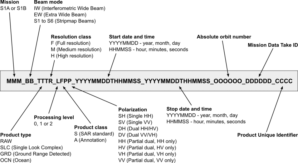
The figure below illustrates the Sentinel-1 granule naming convention. For more information, see the Sentinel-1 Technical Guide.
Orbit Files and Auxilliary Data Files
The Precise Orbit Determination (POD) service for Sentinel-1 provides orbit ephemerides files in the form of Precise Orbit Ephemerides files (available 20 days after data acquisition) and Restituted Orbit files (available a few hours after data acquisition). Flight Operation Segment (FOS) Predicted Orbit files (available seven days before data acquisition), Instrument Processing Facility (IPF) auxiliary files, L1 Processor Parameters, L2 Processor Parameters, Instrument, Calibration, and Simulated Cross Spectra Auxiliary Data are also available.
Access to Sentinel-1 ephemeris files and documentation:
- Sentinel-1 Orbit Files are available from ASF
- Sentinel-1 Orbit Files are available from ESA
- ESA Sentinel-1 Quality Control document links
- COPERNICUS POD SERVICE FILE FORMAT SPECIFICATION
Guide to File Names
| IPF Auxiliary Data Files | Name |
|---|---|
| L1 Processor Parameters | aux_pp1 |
| Calibration Auxiliary Data | aux_cal |
| Instrument Auxiliary Data | aux_ins |
| L2 Processor Parameters | aux_pp2 |
| Orbit Files | Name |
|---|---|
| FOS Predicted Orbit | mpl_orbpre |
| POD Precise Orbit Ephemerides | aux_poeorb |
| POD Restituted Orbit | aux_resorb |
| POD Restitude Attitude | aux_resatt |
Sentinel-1 Data Coverage Heat Maps
Data are open-access and available through Vertex. Click on an image below to see where data products are available.
Cumulative Acquisition Maps
Two Cumulative Heat maps are updated monthly as new data are processed. One map displays the total coverage of Sentinel-1 Ground Range Detected (GRD) product data over the globe from 2014 to the last updated month in the current year, while the other map displays the total coverage of Sentinel-1 Single Look Complex (SLC) product data over the globe for the same time period. A scale of color reflects the total coverage by indicating the number of times an area has been observed.
Current Cumulative: Dec. 31, 2025
Instruments Aboard Sentinel-1
| Instrument Name | Operational Date(s) | Spectral Resolution | Type of Instrument |
|---|---|---|---|
| Sentinel-1 C-band Synthetic Aperture Radar (Sentinel-1 C-SAR) | 1 nm-180nm |
Imaging Radars |
Related Platforms
Frequently Asked Questions
Earthdata Forum
Our online forum provides a space for users to browse thousands of FAQs about research needs, data, and data applications. You can also submit new questions for our experts to answer.
Submit Questions to Earthdata Forumand View Expert Responses


