Earth Science Data Roundup: July 2024
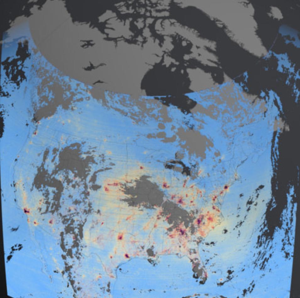
This data visualization from the TEMPO mission shows high levels of nitrogen dioxide over multiple urban areas across the U.S., Canada, Mexico, and the Caribbean (indicated by red/tan colored areas). Detailed views of these regions show high levels of nitrogen dioxide over cities in the morning and enhanced levels of nitrogen dioxide over major highways. Credit: NASA's SVS.
NASA's ASDC released 13 beta Level 1, 2, and 3 Version 03 data products from the Tropospheric Emissions: Monitoring of Pollution (TEMPO) mission:
- Level 1 Dark Exposure, Version 03 (TEMPO_DRK_L1)
- Level 1 Solar Irradiance, Version 03 (TEMPO_IRR_L1)
- Level 1 Solar Irradiance (Reference Diffuser), Version 03 (TEMPO_IRRR_L1)
- Level 1 Geolocated Earth Radiances, Version 03 (TEMPO_RAD_L1)
- Level 1 Geolocated Earth Radiances Twilight, Version 03 (TEMPO_RADT_L1)
- Level 2 Cloud Pressure and Fraction (O2-O2 Dimer), Version 03 (TEMPO_CLDO4_L2)
- Level 3 Gridded Cloud Fraction and Pressure (O2-O2 Dimer), Version 03 (TEMPO_CLDO4_L3)
- Level 2 Formaldehyde Total Column, Version 03 (TEMPO_HCHO_L2)
- Level 3 Gridded Formaldehyde Total Column, Version 03 (TEMPO_HCHO_L3)
- Level 2 NO2 Tropospheric and Stratospheric Columns, Version 03 (TEMPO_NO2_L2)
- Level 3 Gridded NO2 Tropospheric and Stratospheric Columns, Version 03 (TEMPO_NO2_L3)
- Level 2 Ozone Total Column, Version 03 (TEMPO_O3TOT_L2)
- Level 3 Gridded Ozone Total Column, Version 03 (TEMPO_O3TOT_L3)
These data products are provided in netCDF4 format. The beta designation means the products are minimally validated and may contain errors.
For additional information, see TEMPO Mission Releases Beta Level 1, 2, and 3 Version 03 Data Products on the Earthdata website.
New Suite of GEWEX Surface Radiation Budget (SRB) Datasets
A suite of Global Energy and Water Exchanges (GEWEX) Surface Radiation Budget (SRB) Release 4-IP datasets is now available. The suite of products includes:
- GEWEX SRB Integrated Product (Rel-4_1) Longwave Daily Average by Local Land-only Fluxes
- GEWEX SRB Integrated Product (Rel-4_1) Longwave 3-Hourly Ocean-only Fluxes
- GEWEX SRB Integrated Product (Rel-4_1) Longwave 3-Hourly Land-only Fluxes
- GEWEX SRB Integrated Product (Rel-4_1) Longwave Daily Average by Local Ocean-only Fluxes
- GEWEX SRB Integrated Product (Rel-4_1) Longwave Daily Average by Local Fluxes
- GEWEX SRB Integrated Product (Rel-4_1) Longwave Monthly Average by local Ocean-only Fluxes
Release 4-IP products differ substantially from the previous SRB release due to several improvements of the algorithms and input datasets. Temporal coverage of Release 4-IP extends from mid-1983 through mid-2017 for global shortwave fluxes and from 1988 through 2009 for global longwave fluxes. Additional land-only longwave coverage is available from mid-1983 through 1987 and ocean-only from 2010 through mid-2017. All datasets are available in netCDF-4 format.
Access GEWEX SRB datasets and more information
EPIC Cloud Height Dataset Now Available
NASA's ASDC released the DSCOVR EPIC Level 2 CLOUDHEIGHT Version 01 dataset from the Earth Polychromatic Imaging Camera (EPIC) aboard the Deep Space Climate Observatory (DSCOVR) satellite. The data show Cloud Effective Height (CEH) derived using Oxygen A and B-band pairs from the DSCOVR EPIC Level 2 Cloud Version 03 data product. The data are shown on an orthographic projection of Earth, and a color map is used to indicate cloud altitude.
Access the EPIC cloud height dataset and more information
TOLNet City College of New York Data Available
A new dataset from the New York Tropospheric Ozone Lidar System (NYTOLS) at the City College of New York (CCNY), which is part of the Tropospheric Ozone Lidar Network (TOLNet), is available at NASA's ASDC. In operation since 2011, TOLNet is an interagency collaboration between NASA, NOAA, and the Environmental Protection Agency designed to perform studies of air quality, atmospheric modeling, and interpretation of satellite observations.
Access TOLNet CCNY data and more information
Global Space-based Stratospheric Aerosol Climatology Version 2.22 Now Available
The Global Space-based Stratospheric Aerosol Climatology (GloSSAC) is a 44-year climatology of stratospheric aerosol properties focused initially on extinction coefficient measurements acquired by the Stratospheric Aerosol and Gas Experiment (SAGE) series of instruments and later on data from the Optical Spectrograph and InfraRed Imager System (OSIRIS) and the Cloud-Aerosol Lidar and Infrared Pathfinder Satellite Observation (CALIPSO) mission. In addition, data from other space-based, ground-based, and airborne (i.e., plane and balloon) instruments were used to fill gaps in the dataset. The result is a global, gap-free dataset focused on aerosol extinction coefficient at 525 and 1020 nanometers and other parameters on an 'as available' basis.
Access GloSSAC data and more information
Global Hydrometeorology Resource Center Distributed Active Archive Center (GHRC DAAC)
Advanced Vertical Atmospheric Profiling System (AVAPS) Dropsondes Dataset
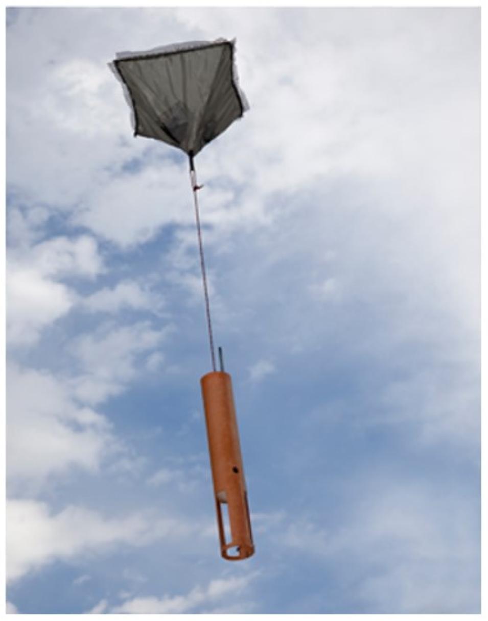
The Airborne Vertical Atmospheric Profiling System (AVAPS), also known as the AVAPS Dropsonde System, is an atmospheric instrument that measures high resolution vertical profiles of ambient temperature, pressure, humidity, wind speed, and wind direction. Measurements are taken by a parachuted GPS dropsonde that is launched from an aircraft and descends to the surface. Credit: NASA.
NASA's GHRC DAAC released the Advanced Vertical Atmospheric Profiling System (AVAPS) dataset from the Investigation of Microphysics and Precipitation for Atlantic Coast-Threatening Snowstorms (IMPACTS) campaign. The dataset consists of vertical atmospheric profile observations collected by AVAPS dropsondes released from the NASA P-3 aircraft. The dropsondes measure atmospheric state parameters (temperature, humidity, wind speed/direction, pressure) and location during their descent. AVAPS dataset files are available from January 12, 2020, through February 28, 2023, and are in ASCII-ict format.
Access AVAPS dropsonde data and more information
Advanced Microwave Precipitation Radiometer (AMPR) IMPACTS Dataset Released
The Advanced Microwave Precipitation Radiometer (AMPR) dataset from the IMPACTS campaign consists of brightness temperature measurements collected by the AMPR instrument aboard the NASA ER-2 high-altitude research aircraft. AMPR provides multi-frequency microwave imagery with high spatial and temporal resolution for deriving cloud, precipitation, water vapor, and surface properties. Data files are available from January 18, 2020, through March 2, 2023, and are in netCDF-4 format.
Access AMPR data and more information
Goddard Earth Sciences Data and Information Services Center (GES DISC)
Updated IMERG Near Real-Time Products Released
NASA's GES DISC, the Global Precipitation Measurement (GPM) Project, and the Precipitation Processing System (PPS) have released version 07 of the Integrated Multi-satellitE Retrievals for GPM (IMERG) Near Real-Time (NRT) datasets. The release encompasses four datasets with different temporal resolutions: the Half-hourly, Early, and Late, and the corresponding Daily datasets. Because of the large number of files, work is still in progress to archive the IMERG Late run version 07 and to ensure search engines show the complete inventory of data files. Since there are numerous science improvements to IMERG version 07 as well as changes to the variable names, users are encouraged to familiarize themselves with the Data Release Notes.
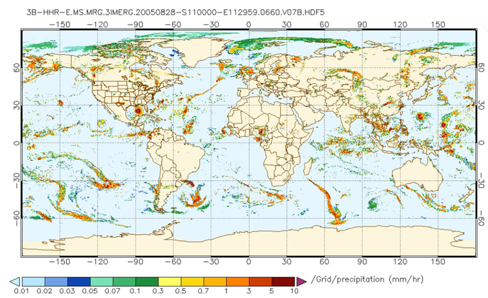
Integrated Multi-satellitE Retrievals for Global Precipitation Measurement Half-Hourly Early (IMERGHHE) version 07 for August 28, 2005, at 11:00 UTC. Hurricane Katrina is visible in the Gulf of Mexico. Rainfall rate is displayed in mm/hr in colors matching the color key at the bottom of the image. Credit: NASA's GES DISC.
Subsetting Capability Added for OCO-2 and ACOS "Lite" Files
Orbiting Carbon Observatory (OCO-2) and Atmospheric CO2 Observations from Space (ACOS) Level 2 "Lite" files can now be subsetted spatially, as well as by variable. The spatial subsets may be selected within a bounding box or within a user-defined radius around a user-specified location (point + radius subsetting).
More information about these new OCO-2 and ACOS capabilities
HAQAST Level 3 GLOBAL TROPOMI Nitrogen Dioxide Collections Version 2.4 Released
NASA's GES DISC and Principal Investigator Dr. Dan Goldberg of George Washington University have released two Level 3 global TROPOspheric Monitoring Instrument (TROPOMI) Nitrogen dioxide (NO2) collections covering the period from January 2019 to the present. These products provide Level 3 tropospheric NO2 vertical column density derived from the Level 2 global TROPOMI data, oversampled to a spatial resolution of 0.1˚ x 0.1˚ (~10 km2) using a consistent algorithm from ESA (European Space Agency). These two datasets are part of the NASA Health And Air Quality Applied Science Team (HAQAST) project.
Access TROPOMI NO2 collections and more information
Carbon Monitoring System (CMS) Carbon Flux Version 3 Datasets Released
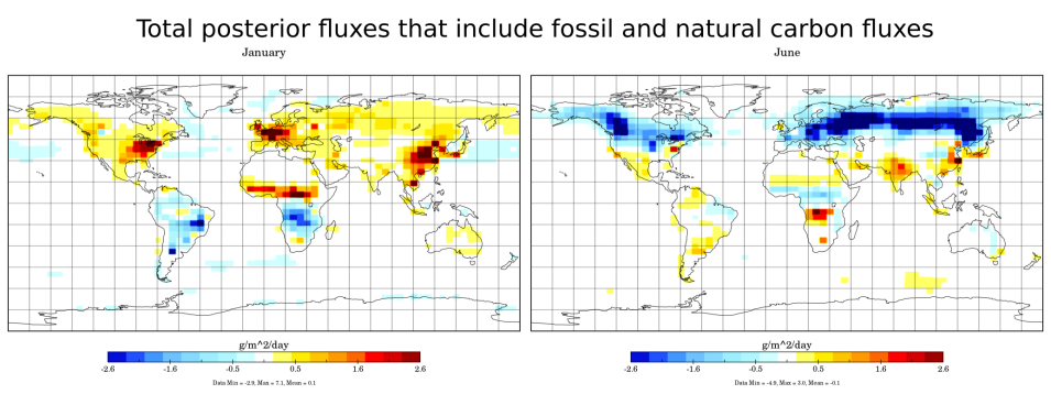
Version 3 of the Carbon Monitoring System (CMS) Carbon Flux datasets is now available at NASA's GES DISC. The Version 3 products contain global estimates of various components of the carbon cycle, constrained by satellite observations, produced by the Carbon Monitoring System Flux (CMS-Flux) carbon cycle data assimilation system. Version 3 of this dataset extends the record from 2010 through 2022. The dataset has a 1º x 1º spatial resolution, which is an interpolation from the original 4º (latitude) x 5º (longitude) resolution.
Land Processes DAAC (LP DAAC)
EMIT Level 4 Earth System Model Data Product Released
This image shows Community Earth System Model 2 output of dust longwave radiative forcing at the top of atmosphere. This layer is derived from EMITL3ASA, MERRA2, and historical emissions/ concentration scenario inputs from the EMITL4ESM data product across the globe from 2007 through 2011. Credit: NASA's LP DAAC.
The Earth Surface Mineral Dust Source Investigation (EMIT) Level 4 Earth System Model Products (EMITL4ESM) Version 1 data product is now available at NASA's LP DAAC. This product provides radiative forcing outputs along with other ancillary outputs generated from different Earth System Models (ESMs) designed to help researchers better understand how surface mineralogy and atmospheric dust impact the heating and cooling of Earth's atmosphere and surface. These data are based on multiple models, meteorological inputs, emissions/concentration scenarios, and input mineral maps using EMIT Level 3 Aggregated Mineral Spectral Abundance and Uncertainty 0.5 Deg (EMITL3ASA) data.
Access the EMIT Level 4 product and more information
Forward Processing for Most VIIRS Version 1 Products Ended as of June 17
Forward processing for Visible Infrared Imaging Radiometer Suite (VIIRS) Version 1 (Collection 1) land data products ended on June 17, 2024. The only exceptions will be for the Bidirectional Reflectance Distribution Function (BRDF) and Albedo products, whose forward processing will resume by early July and continue until the Version 2 (Collection 2) reprocessing is fully complete over the historical mission period. For all other land products, users are urged to switch to Version 2 data products, which have better radiometric calibration and are more consistent with the data products from the Moderate Resolution Imaging Spectroradiometer (MODIS) instrument aboard NASA’s Aqua satellite for long-term climate studies.
More information about VIIRS data product forward processing
ECOSTRESS Build 7.12 Released
The ECOsystem Spaceborne Thermal Radiometer Experiment on Space Station (ECOSTRESS) has moved to Build 7.12 to account for a newer version of the VIIRS input (VIIRS Collection 2, Version 2, released on June 17, 2024) into the evapotranspiration (ET) product. The newer version of VIIRS input differs by <1% in the surface reflectance product, which has minimal impact to the ET end product.
More informatiom about ECOSTRESS Build 7.12
National Snow and Ice Data Center DAAC (NSIDC DAAC)
SnowEx23 Snow Water Equivalent, Version 1 Dataset Now Available
The SnowEx23 Snow Water Equivalent, Version 1 dataset is now available at NASA's NSIDC DAAC. This dataset contains snow depth, snow water equivalent, and bulk snow density data collected during the NASA SnowEx 2023 field campaign. The temporal range spans from March 13 to March 16, 2023.
More information about the SnowEx23 dataset and data access
SnowEx21 Time Series Snow Pits, Version 1 Dataset Released
The SnowEx21 Time Series Snow Pits, Version 1 dataset is now available from NASA's NSIDC DAAC. This dataset contains a time-series of snow pit measurements obtained from sites distributed over four states (Colorado, Idaho, Montana, and Utah) during the 2021 field campaign. Available measured parameters are snow depth, snow temperature, snow density, stratigraphy, grain size, manual wetness, liquid water content, and snow water equivalent. The dataset's temporal range is November 2020 to May 2021.
More information about the SnowEx21 dataset and data access
New Layers in GLIMS Glacier Viewer
The Global Land Ice Measurements from Space (GLIMS) Glacier Viewer now includes both versions 6.0 and 7.0 of the Randolph Glacier Inventory (RGI) outlines as layers. This feature allows users to directly compare the two RGI outline versions using a map-based interface without the need to download data.
More information about this GLIMS enhancement
MEaSUREs Greenland Image Mosaics and 6- and 12-day Ice Sheet Velocity Mosaics Datasets Updated
Updated versions of the NASA Making Earth System Data Records for Use in Research Environments (MEaSUREs) Greenland Image Mosaics from Sentinel-1A and -1B, Version 4 and Greenland 6- and 12-day Ice Sheet Velocity Mosaics from SAR, Version 2 datasets are available. The temporal coverage for the image mosaics has been extended until March 31, 2024, and the 6- and 12-day velocity mosaics now spans until March 19, 2024.
More information about the updated MEaSUREs datasets and data access
Replacement of High Mountain Asia Dataset Files
The following files from the High Mountain Asia Daily 5-kilometer Downscaled Seamless System for Prediction and EArth System Research (SPEAR) Precipitation and Air Temperature Projections, Version 1 dataset have been replaced:
- HMA2_DSPAT_tas_hist_r12i1p1f1_19900101-20001231_v01.0.nc
- HMA2_DSPAT_tas_hist_r13i1p1f1_19900101-20001231_v01.0.nc
- HMA2_DSPAT_tas_hist_r4i1p1f1_20110101-20141231_v01.0.nc
- HMA2_DSPAT_tas_hist_r25i1p1f1_20110101-20141231_v01.0.nc
The corrected files are renamed to "v01.1".
More information about the renaming of the High Mountain Asia datasets
Oak Ridge National Laboratory DAAC (ORNL DAAC)
New Salt Marsh Biomass Dataset
The Aboveground Biomass Estimates for Salt Marsh for the Contiguous United States, 2020 dataset includes all coastal watersheds across the contiguous United States at 10-meter resolution, with data provided in cloud-optimized GeoTIFF format.
Access the Aboveground Biomass Estimates 2020 dataset and more information
GEDI Mission Releases Gridded Forest and Vegetation Structure and Biomass Density Datasets
Two new datasets from the Global Ecosystem Dynamics Investigation (GEDI) mission are available at NASA's ORNL DAAC:
- The Gridded GEDI-Fusion Forest Structure Metrics across Six Western US States, 2016-2020 dataset provides eight GEDI forest structure metrics relevant to wildlife habitat modeling and biodiversity assessments at 30-meter resolutions across Washington, Oregon, Idaho, Montana, Wyoming, and Colorado. The metrics characterize canopy height, strata densities, and canopy cover and were derived using random forest modeling and prediction frameworks. The models created were also hindcasted using 2019 and 2020 GEDI footprints back to 2016 on annual time steps leveraging continuous Landsat spectral and disturbance information, Sentinel-1 backscatter metrics and ratios, topographic information, and bioclimatic variables. Access GEDI Fusion Forest Structure Metrics and more information
- The Gridded GEDI Vegetation Structure Metrics and Biomass Density at Multiple Resolutions dataset consists of near-global, analysis-ready, multi-resolution gridded vegetation structure metrics derived from GEDI Level 2 and 4A products (Version 2) associated with 25-m diameter lidar footprints. This product provides a comprehensive representation of near-global vegetation structure that is inclusive of the entire vertical profile, based solely on GEDI lidar, and validated with independent data. It also offers GEDI shot metrics aggregated into raster grids at three spatial resolutions: 1 km, 6 km, and 12 km. Beyond many of the standard L2 and L4A shot metrics, several additional metrics have been derived that may be useful for applications in carbon and water cycling processes in Earth system models, as well as forest management, biodiversity modeling, and habitat assessment. Files are provided in Cloud-Optimized GeoTIFF format. Access GEDI Vegetation Structure Metrics and more information
Now Available: Delta-X UAVSAR Level 3 Gridded Open Water Channels and Modeled Land Accretion Rate Maps Datasets
NASA's ORNL DAAC released two new datasets from NASA's Delta-X campaign:
- The Delta-X: UAVSAR Level 3 Gridded Open Water Channels, Mississippi River Delta, Louisiana, USA, 2021, Version 2 dataset provides gridded estimates of water channels for the Atchafalaya and Terrebonne basins of the Mississippi River Delta. The data show channels with open water that are as narrow as 10 meters. These channel estimates were generated from the Uninhabited Aerial Vehicle Synthetic Aperture Radar (UAVSAR) Level 1B interferometric products in radar coordinates acquired in the 2021 spring and fall Delta-X deployments, and have a spatial resolution of approximately 6 meters. The channel estimates can be used to define open water paths in hydrodynamic models and to evaluate model performance. Data are provided in Cloud-Optimized GeoTIFF format. Access the Delta-X UAVSAR dataset and more information
- The Delta-X: Modeled Land Accretion Rate Maps, Wax Lake Delta, Mississippi River Delta, Louisiana, USA, 2021 dataset provides sediment transport and land accretion model results at Wax Lake Delta (WLD), Atchafalaya Basin, in coastal Louisiana. Data were simulated over the Delta-X Spring 2021 (March 21 to April 3, 2021) and Fall 2021 (August 14 to August 27, 2021) campaigns, and the results are presented as an annualized land accretion rate map. The model results for these two short-term campaigns are used to calculate the 1-year upscale land accretion rate at WLD in post-processing, which is also provided in this dataset. Data are provided in netCDF format. Access the Delta-X WLD dataset and more information
COMEX Project Releases AJAX, AVIRIS-Classic, and AVIRIS-NG Datasets
NASA's ORNL DAAC released three new datasets from the CO2 and MEthane eXperiment (COMEX):
- The Flight Information for AJAX Airborne In Situ CO2 and CH4, 2014-2015 dataset from the COMEX Project provides information to access published flight data and flight information collected by the Alpha Jet Atmospheric eXperiment (AJAX) in 2014 to 2015. The in-situ data include measurements of carbon dioxide (CO2), methane (CH4), and water (H2O) at 2 Hz or CH4 and H2O at 10 Hz with a strategy of characterizing atmospheric structure over ocean and land, and vertical profiles to at least 5,000 meters. Ancillary data, including ozone, formaldehyde, and meteorological profiles, were also collected. This dataset provides filenames, spatiotemporal bounds, and download URLs for accessing these in-situ data, which are provided in comma separated values (CSV) format. Access AJAX data and more information
- The AVIRIS-Classic Facility Instrument Associated Flights and Information 2014 dataset lists flight lines and provides data access links and contextual flight information for a subset of the AVIRIS-Classic Facility Instrument Collection. The COMEX Project utilized several measurement capabilities including the AVIRIS-Classic airborne facility instrument data to demonstrate that methane emissions associated with fossil fuel production activities in the Los Angeles, California, area were of sufficient magnitude and size for space-based observations. These lists of the associated COMEX flights from the AVIRIS-Classic Facility Instrument provide flight lines and access information for the Level 1B Calibrated Radiance data and the Level 2 Calibrated Reflectance data. Access AVIRIS-Classic COMEX data and more information
- The AVIRIS-NG Facility Instrument Associated Flights and Information, 2014 dataset lists flight lines and provides data access links and contextual flight information for a subset of the Airborne Visible InfraRed Imaging Spectrometer-Next Generation (AVIRIS-NG) Facility Instrument Collection. The COMEX Project utilized several measurement capabilities including the AVIRIS-NG airborne facility instrument data to demonstrate that methane emissions associated with fossil fuel production activities in the Los Angeles, California, area were of sufficient magnitude and size for space-based observations. Lists of the associated COMEX flights from the AVIRIS-NG Facility Instrument provide flight lines and access information for the Level 1B Calibrated Radiance data and the Level 2 Calibrated Reflectance data. Access AVIRIS-NG dataset lists and more information
Ignitions of ABoVE-FED Fires in Alaska and Canada Dataset Released
The Ignitions of ABoVE-FED Fires in Alaska and Canada dataset provides daily fire ignition locations and timing for boreal fires in the U.S. state of Alaska and in Canada between 2001 and 2019. The fire ignition locations and timing are extracted from the Arctic-Boreal Vulnerability Experiment (ABoVE) Fire Emission Database (FED); however, the temperate prairies of Canada, the Atlantic Highlands, and Mixed Wood Plains were not included. Fires were detected from Landsat differenced normalized burn ratio (dNBR) and the daily MODIS burned area and active fire products. Detections by dNBR were limited to fire perimeters from national fire databases. The temporal resolution of the ignition timing is within one day. Data are provided in comma separated values (CSV) and shapefile formats.
Access the ABoVE-FED Fires dataset and more information
Development and Evolution of NASA Satellite Remote Sensing for Ecology
NASA's ORNL DAAC released the Development and Evolution of NASA Satellite Remote Sensing for Ecology dataset, which provides a presentation that highlights the role NASA research and researchers played in developing a wide range of significant, quantitative ecological applications of satellite data. The presentation emphasizes the early years of U.S. satellite remote sensing and covers a few highlights after 2005.
Access the presentation and more information
MASTER: FireSense, Western United States, October 2023
The MASTER: FireSense, western United States, October 2023 dataset includes Level 1B data products from the MODIS/ASTER Airborne Simulator (MASTER) instrument. The spectral data were collected as part of the NASA FireSense project during 11 flights aboard a NASA B200 aircraft over California, Nevada, Utah, and Arizona from October 16 to October 26, 2023. The dataset also includes flight paths, spectral band information, instrument configuration, ancillary notes, and summary information for each flight along with browse images derived from each Level 1B data file. Data are available in HDF-4 format.
Access the FireSense dataset and more information
New Daymet Datasets Released
Two new Daymet datasets are available:
- The Daymet Station-Level Inputs and Cross-Validation for North America, Version 4 dataset reports the station-level daily weather observation data and the corresponding cross-validation results for three Daymet model parameters: minimum temperature (tmin), maximum temperature (tmax), and daily total precipitation (prcp) across continental North America (including Canada, the United States, Mexico, Hawaii, and Puerto Rico). Each data file contains the daily observations and cross-validation results for one parameter for each modeled region from 1980 to present for stations across continental North America and Hawaii and from 1950 to present for Puerto Rico. Also included are corresponding station metadata files listing every surface weather station used in Daymet processing for each parameter, region, and year and containing the station name, station identification, latitude, and longitude. The data are provided in netCDF and text formats. Access the Daymet Station-Level Inputs and Cross-Validation dataset and more information
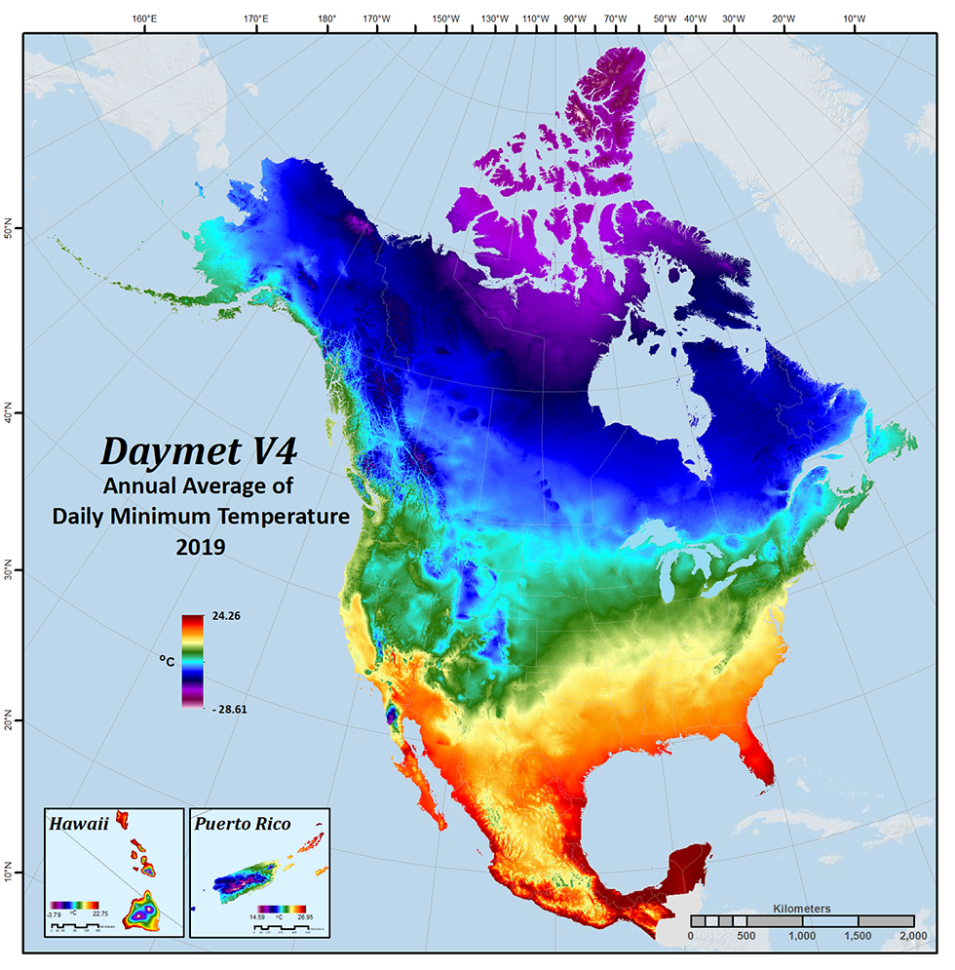
- The Daymet: Monthly Climate Summaries on a 1-km Grid for North America, Version 4 R1 dataset provides Daymet Version 4 R1 monthly climate summaries derived from Daymet Version 4 R1 daily data at a 1 km x 1 km spatial resolution for five Daymet variables: minimum and maximum temperature, precipitation, vapor pressure, and snow water equivalent. Monthly averages are provided for minimum and maximum temperature, vapor pressure, and snow water equivalent, and monthly totals are provided for the precipitation variable. Each data file is yearly by variable with 12 monthly time steps and covers the same period of record as the Daymet V4 R1 daily data. The monthly climatology files are derived from the larger datasets of daily weather parameters produced on a 1 km x 1 km grid for North America, Hawaii, and Puerto Rico. Separate monthly files are provided for the land areas of continental North America (i.e., Canada, the United States, and Mexico), as well as for Hawaii and Puerto Rico. Data are distributed in standardized Climate and Forecast (CF)-compliant netCDF and Cloud-Optimized GeoTIFF formats. Access Daymet Monthly Climate Summaries and more information
Daymet provides long-term, continuous, gridded estimates of daily weather and climatology variables by interpolating and extrapolating ground-based observations through statistical modeling techniques. Daymet Version 4 (V4) was released in December 2020. Credit: NASA's ORNL DAAC.
Physical Oceanography DAAC (PO.DAAC)
SMAP RSS Sea Surface Salinity V5.3 Evaluation Dataset Released
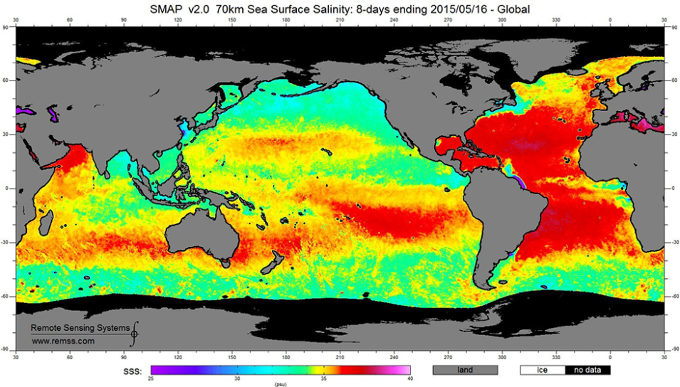
NASA's PO.DAAC released the Version 5.3 Soil Moisture Active Passive (SMAP) Sea Surface Salinity (SSS) evaluation datasets. The evaluated Version 5.3 is identical to the Version 6.0 validated release with the exception that Version 5.3 uses the Version 5 Level 1B antenna temperatures (TA) as input. The Version 6.0 Level 1B TA uses a lower TA threshold for radio frequency interference (RFI) exclusion, thus excluding more potential RFI contamination. Until the full back-processing of V6.0 is complete, PO.DAAC advises that the evaluation Version 5.3 should be used. Version 5.3 has been processed from the beginning of the SMAP mission to the end of 2023. This release includes Level 2C, Level 3 mapped monthly, and 8-day running mean datasets. All products are in netCDF-4 file format.
Socioeconomic Data and Applications Center (SEDAC)
Low Elevation Coastal Zone (LECZ) Global Delta Urban-Rural Population and Land Area Estimates Dataset Available
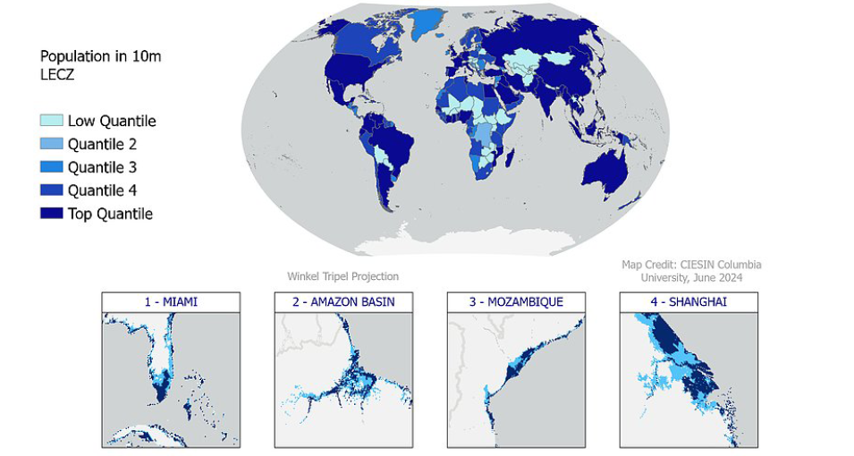
NASA's SEDAC released the Low Elevation Coastal Zone (LECZ) Global Delta Urban-Rural Population and Land Area Estimates, Version 1 dataset. This dataset provides country-level estimates of urban, quasi-urban, rural, and total population (count); land area (in square kilometers); and built-up areas in river delta- and non-delta contexts for 246 statistical areas (countries and other UN-recognized territories) for the years 1990, 2000, 2014, and 2015. The population estimates are disaggregated such that compounding risk factors including elevation, settlement patterns, and delta zones can be cross-examined. The data are layered spatially, along with political and land/water boundaries, allowing the densities and quantities of population and built-up area, as well as levels of urbanization (defined as the share of population living in "urban centers") to be estimated for any country or region, both inside and outside the LECZs and deltas, and at two points in time: 1990 and 2015.
The Low Elevation Coastal Zone (LECZ) Global Delta Urban-Rural Population and Land Area Estimates, Version 1 dataset provides country-level estimates of urban, quasi-urban, rural, and total population (count), land area (square kilometers), and built-up areas in river delta- and non-delta contexts for 246 statistical areas (countries and other UN-recognized territories) for the years 1990, 2000, 2014, and 2015. Credit: NASA's SEDAC.
