- Air Quality
- Ash Plumes
- Drought
- Dust Storms
- Fires
- Floods
- Severe Storms
- Shipping
- Smoke Plumes
- Vegetation
NASA's Land, Atmosphere Near real-time Capability for EOS (LANCE) Earth Observing System (EOS) data and imagery enable users to get a snapshot of the Earth in near-real time (NRT). This timely data is useful for a range of applications e.g. to detect fires, track smoke, ash and dust plumes; to monitor aerosols, carbon monoxide (CO) and sulfur dioxide (SO2), which in turn are useful for air quality assessments; and to determine the extent of sea ice, snow, and flooding which are useful to support shipping in the polar regions and to allow rapid assessment of areas worst affected by snow or flood water. Visualize the data by category in Worldview.
Register for an Earthdata Login to start downloading data.
Please read the LANCE disclaimer for more information about using the data.
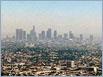 |
Air QualitySatellite data have been used to track propagation of toxic gases like CO from massive fires; accurate early warnings of such pollution spikes are useful because they give people the option to reduce their risk of exposure to poor air by limiting outdoor activity at these times. |
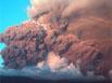 |
Ash PlumesSatellite data are useful for identifying and tracking ash plumes from volcanic eruptions. The use of NRT satellite data for monitoring volcanic plumes is undergoing further developments to enable quantitative retrievals to be produced, which should enable a global capability for volcanic ash monitoring to be introduced. |
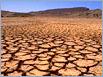 |
DroughtAgro-climatic monitoring programs and global food security risks are monitored using NRT satellite data including the U.S. Agency for International Development (USAID) Famine Early Warning Systems Network (FEWS NET) and GEOGLAM. |
 |
Dust StormsDust storms can have an impact on human health, weather patterns as well as cause disruption through flight delays and the closure of highways. Data from LANCE are used to monitor and predict dust storms. This information is used by agencies within the Department of Defense to improve resource allocation in remote areas and help promote aircraft safety. |
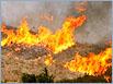 |
FiresUltra Real-Time (URT), Real-Time (RT), NRT satellite data and imagery enable people on the ground, including those responsible for mobilizing fire-fighting resources around the world, detailed information about the locations of fires. URT, RT and NRT MODIS, VIIRS and Landsat active fire/hotspot data are available in easy to use formats through the Fire Information for Resource Management System (FIRMS). |
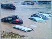 |
FloodsMapping floodwater extent for active floods is critical for local and regional officials and for disaster relief organizations that need to ascertain where to focus their efforts. |
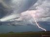 |
Severe StormsMODIS data are used to revise or confirm 24-hour forecasts related to weather systems approaching the land from the oceans, which in turn gives confidence for flood warnings. Satellite images are also useful in providing everyone with the same 'big picture' of severe storms. |
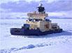 |
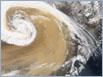
ShippingIn the polar regions, NRT satellite imagery provided by LANCE are routinely, in combination with other data, are used to provide up-to-date information on sea ice conditions to ships and research vessels. |
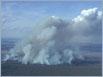 |
Smoke PlumesTrue color imagery and satellite-derived aerosol and carbon monoxide products are frequently used to track the source, duration and transport of smoke plumes across large areas. Smoke from large wildfires to be lofted high enough into the atmosphere that winds push plumes long distances; a process that can often be tracked in near-real time using data from LANCE. |
 |
VegetationNormalized Difference Vegetation Index (NDVI) images produced from LANCE data are used to monitor vegetation and crop condition. Groups such as the United Nations (UN) Food and Agriculture Organization (FAO) Desert Locust Information Service flag anomalies in vegetation. |
Related NASA links
Disasters Program - including data portal for specific disasters
NASA Earth Observatory - Natural Events
NASA Applied Remote Sensing Training - Disasters
SARVIEWS Hazard Portal - A SAR-based hazard monitoring service
NASA Data Pathfinders
- Agricultural and Water Resources
- Biological Diversity and Ecological Forecasting
- Disasters
- Wildfires
- Health and Air Quality