NASA Earth Science Data Roundup: October 2023
NASA’s GES DISC announced that the Geospatial Interactive Online Visualization ANd aNalysis Infrastructure (Giovanni) and the time-aggregated THREDDS Data Server (TDS) have been integrated for two statistical collections derived from Modern-Era Retrospective analysis for Research and Applications, Version 2 (MERRA-2) products: the Extreme Detection Indices Collection Version 2 and the Monthly Percentiles Collection Version 2. These collections facilitate studies of extreme temperature and precipitation events from January 1980 to the present.
MERRA-2 Hourly PM2.5 Data Now in Giovanni
The hourly surface mass concentration and column mass density of particulate matter smaller than 2.5 microns (PM2.5) for individual components, and the hourly total PM2.5 derived from MERRA-2 have been added to Giovanni. These high temporal resolution data variables will be useful for studying the temporal variation (especially hourly variation) of air pollution events, such as wildfires and dust storms.
Land Processes Distributed Active Archive Center (LP DAAC)
EMIT Methane Detection Data Products Released
NASA's LP DAAC released the Earth Surface Mineral Dust Source Investigation (EMIT) Level 2B Methane Enhancement Data and Level 2B Estimated Methane Plume Complexes data products at a 60-meter spatial resolution. These data products provide methane enhancements and estimated methane plume complexes in Cloud Optimized GeoTIFF format. The products are primarily based on the EMIT L1B At-Sensor Calibrated Radiance and Geolocation Data product and use an adaptive matched filter process along with a manual review process to identify methane plume complexes.
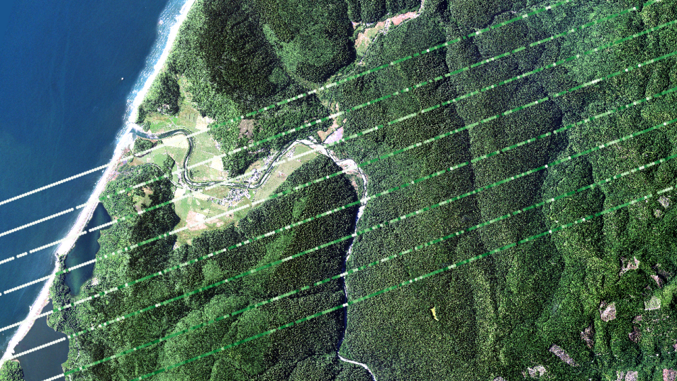
This image shows Version 2 GEDI Level 2B Plant Area Index (PAI) data over Redwoods National Park in California on June 19, 2019. The base map is USDA National Agriculture Imagery Program (NAIP) imagery from 2020. Credit: NASA's LP DAAC.
Final GEDI Version 2 Data for December 2022 through March 2023 Delivered
LP DAAC announced the delivery of three Global Ecosystem Dynamics Investigation (GEDI) Version 2 data products—Level 1B Geolocated Waveform Data, Level 2A Elevation and Height Metrics Data, and Level 2B Canopy Cover and Vertical Profile Metrics Data—covering December 22, 2022, through March 16, 2023. The delivery of these products completes the GEDI Version 2 product suite.
GEDI Version 2 data access and more information
VIIRS Version 2 Thermal Anomalies and Fire Data Products Now Available
Version 2 of the Visible Infrared Imaging Radiometer Suite (VIIRS) Thermal Anomalies and Fire product suite is now available and includes data products from both the joint NASA/NOAA Suomi National Polar-orbiting Partnership (Suomi NPP) and NOAA-20 satellites. This release covers the joint mission period from 2018 to present. Suomi NPP VIIRS Version 1 Thermal Anomalies and Fire data products will remain available and will continue with forward processing during the transition to Version 2.
VIIRS Version 2 Thermal Anomalies and Fire data access and more information
Level 1 and Atmosphere Archive and Distribution System (LAADS DAAC)
Two New Versions of the Level-2 Dark Target Aerosol Data Products Released
NASA's LAADS DAAC released two new products: the NOAA-20 and the Suomi NPP VIIRS Dark Target Aerosol Level-2 6-Minute Swath 6 km. These products provide global satellite-derived measurements of aerosol optical thickness (AOT) and its properties over land and ocean, and global spectral AOT and its size parameters over oceans.
VIIRS Level-2 Dark Target Aerosol data access and more information
Release of NRT VIIRS Collection 2 Land Products and Decommissioning of Collection 1 Products
All near real-time (NRT) VIIRS Collection 1 land products will be switched to Collection 2 on or during the week of October 9, 2023. The Collection 2 land products will include NRT land products from the Joint Polar Satellite System’s NOAA-20 satellite in NASA’s Land, Atmosphere Near real-time Capability for EOS (LANCE) for the first time.
The Collection 2 land products from the VIIRS instrument aboard the Suomi NPP and NOAA-20 satellites have been generated using Level 1B products that have been cross-calibrated for visible, near infrared, and shortwave infrared bands to mitigate bias in observed top of atmosphere reflectance values using the Moderate Resolution Imaging Spectroradiometer (MODIS) instrument aboard NASA’s Aqua satellite for reference.
CoreTrustSeal Recertifies LAADS DAAC
LAADS DAAC was recently re-certified as a trustworthy data archive by the CoreTrustSeal Standards and Certification Board through September 4, 2026. CoreTrustSeal is an international non-governmental and nonprofit organization that promotes sustainable and trustworthy data infrastructures.
LAADS DAAC re-certified by CoreTrustSeal
National Snow and Ice Data Center Distributed Active Archive Center (NSIDC DAAC)
NASA’s NSIDC DAAC released or updated the following new datasets in September:
MEaSUREs Global Record of Daily Landscape Freeze/Thaw Status, Version 5
The Making Earth System Data Records for Use in Research Environments (MEaSUREs) Global Record of Daily Landscape Freeze/Thaw Status, Version 5 dataset has been updated through December 31, 2021. This dataset provides the Freeze/Thaw status of the landscape, in the morning and afternoon, at 25 km on the original EASE-Grid.
The Freeze/Thaw status is now provided as a single Earth System Data Record derived from the Scanning Multichannel Microwave Radiometer (SMMR) instrument aboard the Nimbus-7 satellite and the Special Sensor Microwave/Imager (SMM/I) and Special Sensor Microwave Imager Sounder (SSMIS) instruments aboard the Defense Meteorological Satellite Program’s (DMSP) satellites from 1979 to 2020, and the Advanced Microwave Scanning Radiometer 2 (AMSR2) instrument aboard the JAXA (Japan Aerospace Exploration Agency) Global Change Observation Mission-Water (GCOM-W1) satellite from 2021 onwards.
MEaSUREs Global Record of Daily Landscape Freeze/Thaw data access and more information
Randolph Glacier Inventory—A Dataset of Global Glacier Outlines, Version 7
Version 7 of the Randolph Glacier Inventory, a Dataset of Global Glacier Outlines, is now available. This dataset is a global set of glacier outlines intended as a snapshot of the world’s glaciers beyond the ice sheets. It provides a single outline for each glacier at approximately the year 2000 as well as a set of attributes and other relevant auxiliary information.
For this version, the quality of outlines in many regions has improved substantially due to the inclusion of new, updated inventory data. Some attributes have been removed, renamed, or redefined, while new ones are now available. In addition to the outlines of individual glaciers, outlines of contiguous glacier complexes are now available (i.e., the “glacier complex" product). New shapefiles of common boundaries of individual glaciers, as well as glacier centerlines, have been added (“intersects" and "centerlines" products). All outlines and attributes are derived exclusively from the Global Land Ice Measurements from Space (GLIMS) initiative.
Randolph Glacier Inventory data access and more information
Sea Ice Concentrations from Nimbus-7 SMMR and DMSP SSM/I-SSMIS Passive Microwave Data, Version 2
The Sea Ice Concentrations Passive Microwave Data, Version 2 dataset, created with data from the SMMR, SMM/I, and SSMIS instruments, has been updated through March 31, 2023. This dataset is generated from brightness temperature data and is designed to provide a consistent time series of sea ice concentrations spanning the coverage of several passive microwave instruments. The data are provided in the polar stereographic projection at a grid cell size of 25 x 25 kilometers.
Sea Ice Concentrations from Nimbus-7 SMMR and DMSP SSM/I-SSMIS data access and more information
SnowEx20 Boise River Basin SnowMicroPen (SMP) Raw Penetration Force Profiles, Version 1
Version 1 of the SnowEx2020 Boise River Basin SnowMicroPen Raw Penetration Force Profiles dataset is now available. This dataset contains raw penetration force profiles from the SnowEx 2020 time series campaign in the Boise River Basin in Idaho. Temporal coverage is from December 18, 2019, to January 24, 2020.
SnowEx20 Boise River Basin SMP data access and more information
SMAPVEX19-22 Massachusetts/Millbrook Airborne Lidar, Version 1
The Soil Moisture Active Passive Validation Experiment (SMAPVEX) 2019-2022 Millbrook Airborne Lidar and SMAPVEX 2019-2022 Massachusetts Airborne Lidar, Version 1 datasets, are now available. These lidar measurements were collected in April and August 2022 in the vicinity of Millbrook, New York, and Petersham, Massachusetts, during the SMAPVEX19-22 campaign. These locations were chosen due to their forested land cover, as SMAPVEX19-22 aims to validate satellite-derived soil moisture estimates in forested areas. The two acquisition periods were selected to characterize differences during “leaf-off” and “leaf-on” conditions.
SMAPVEX19-22 Massachusetts/Millbrook Airborne Lidar data access and more information
ATLAS/ICESat-2 Level 3B Monthly 3-Month Gridded Dynamic Ocean Topography, Version 1
The Advanced Topographic Laser Altimeter System (ATLAS)/Ice, Cloud, and Land Elevation Satellite-2 (ICESat-2) Level 3B Monthly 3-Month Gridded Dynamic Ocean Topography (ATL23), Version 1 dataset is now available. This dataset contains gridded averages of dynamic ocean topography over midlatitude, north-polar, and south-polar grids derived from the along-track ATLAS/ICESat-2 Level 3A Ocean Surface Height product. Data are averaged over a three month sliding window that advances in monthly increments. Spatial coverage spans the world’s ocean from approximately 88° North to 88° South. Temporal coverage is currently from October 14, 2018, to May 31, 2023, and will be updated regularly.
ATLAS/ICESat-2 L3B Mean Inland Surface Water Data, Version 3
NSIDC DAAC has released Version 3 of the ATLAS/ICESat-2 Level 3B Mean Inland Surface Water Data dataset. This dataset contains mean water surface heights for transects over inland water bodies derived from ATLAS/ICESat-2 Level 3A Along Track Inland Surface Water Data. Temporal coverage currently is October 14, 2018, to June 21, 2023, and is updated regularly. Spatial coverage is global. Changes with Version 3 are detailed in the Section 3 Version History of the user guide.
Version 2 of this dataset will be retired in six months, and Version 2 data will no longer be accessible. All related documentation will remain available on the dataset web pages for future reference.
ATLAS/ICESat-2 L3B Mean Inland Surface Water data access and more information
High Mountain Asia 5 Arc-Minute Hydrological Flow Direction for the Headwaters of the Amu Darya and Indus River Basins, Version 1
The High Mountain Asia 5 Arc-Minute Hydrological Flow Direction for the Headwaters of the Amu Darya and Indus River Basins, Version 1 dataset is now available. This dataset contains hydrological flow directions at 5 arc-minute resolution for the headwaters of the Amu Darya and Indus River basins. The domain spans parts of Afghanistan, Tajikistan, Kyrgyzstan, and Pakistan.
These data were developed to support the University of New Hampshire Water Balance Model and the High Mountain Asia Coupled Model Intercomparison Project Phase 6 Monthly and Yearly Water Balance Projections, 2016–2099 for Parts of Afghanistan, Tajikistan, Kyrgyzstan, and Pakistan, Version 1 dataset.
High Mountain Asia 5 Arc-Minute Hydrological Flow Direction data access and more information
Oak Ridge National Laboratory Distributed Active Archive Center (ORNL DAAC)
GEDI L3 Gridded Land Surface Metrics, Version 2
NASA’s ORNL DAAC released Version 2 GEDI Level 3 granules covering April 2019 to March 2023 (GEDI mission weeks 19 through 223). These GEDI Level 3 data provide gridded mean canopy height, standard deviation of canopy height, mean ground elevation, standard deviation of ground elevation, and counts of valid laser footprints per 1 kilometer x 1 kilometer grid cells.
GEDI L3 Gridded Land Surface Metrics data access and more information
GEDI L4A Footprint Level Aboveground Biomass Density, Version 2.1
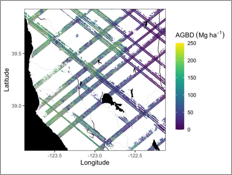
Updated GEDI Version 2.1 Level 4A data are now available for December 22, 2022, through March 16, 2023 (GEDI mission weeks 211 through 223).The GEDI Level 4A data provide predictions of the aboveground biomass density (AGBD) in megagrams per hectare (Mg/ha) and estimates of the uncertainty within each sampled geolocated laser footprint. The data are available through various NASA Earthdata data tools and services, including the Earthdata Cloud, OPeNDAP, and Harmony.
GEDI L4A Footprint Level Aboveground Biomass Density data access and more information
AVIRIS-Classic: L2 Calibrated Reflectance, Facility Instrument Collection
ORNL DAAC recently released the Airborne Visible/ Infrared Imaging Spectrometer (AVIRIS-Classic) Level 2 Calibrated Reflectance, Facility Instrument Collection. This dataset contains Level 2 orthocorrected reflectance data from the AVIRIS-Classic instrument, a pushbroom spectral mapping system with high signal-to-noise ratio designed and toleranced for high-performance spectroscopy. For each flight line, two types of Level 2 data files may be included: (a) calibrated surface reflectance and (b) water vapor and optical absorption paths for liquid water and ice. The Level 2 data are provided in Environment for Visualizing Images (ENVI) format, which includes a flat binary file accompanied by a header (.hdr) file holding metadata in text format. This archive currently includes data from 2008 to 2020. Additional AVIRIS-Classic facility instrument Level 2 data will be added as they become available.
AVIRIS-Classic: L2 Calibrated Reflectance data access and more information
Delta-X: AVIRIS-NG BRDF-Adjusted Surface Reflectance, Mississippi River Delta, Louisiana, 2021, Version 2 dataset
ORNL DAAC released the Airborne Visible/Infrared Imaging Spectrometer-Next Generation (AVIRIS-NG) Bidirectional Reflectance Distribution Function (BRDF)-Adjusted Surface Reflectance, Mississippi River Delta, Louisiana, 2021, Version 2 dataset from the Delta-X mission.
This dataset provides AVIRIS-NG BRDF and Sun glint-corrected surface spectral reflectance images over the Atchafalaya and Terrebonne basins of the Mississippi River Delta of coastal Louisiana. Flights were acquired during the Delta-X spring and fall 2021 deployments. The imagery was acquired by the AVIRIS-NG from March 27 to April 6, 2021, and August 18 to September 25, 2021. Ten files of mosaicked flight lines, by time period and over four locations (labeled Terre, Atcha, TerreEast, and Bara), are also included.
Delta-X: AVIRIS-NG BRDF-Adjusted Surface Reflectance data access and more information
Physical Oceanography Distributed Active Archive Center (PO.DAAC)
CSR GRACE-FO Level-2 Monthly Geopotential Spherical Harmonics RL06.2 Dataset
NASA's PO.DAAC released the Gravity Recovery and Climate Experiment Follow-on (GRACE-FO) Level-2 Monthly Geopotential Spherical Harmonics RL06.2 dataset from the Center for Space Research (CSR).
This CSR GRACE-FO RL06.2 dataset is an updated version of the initial GRACE-FO RL06 Level 2 data products. RL06.2 differs from RL06.1 only in the handling of Global Positioning System (GPS) data during Level-2 processing. GPS handling for RL06.2 was re-assessed due to steady degradation in low degrees during late 2022 and 2023 in RL06.1. The resulting RL06.2 time series shows improvement in the low degree coefficients after 2022.
HiTIDE Transitions to the Cloud
PO.DAAC's High-level Tool for Interactive Data Extraction (HiTIDE) is transitioning to the cloud. The new and improved HiTIDE includes all the previous functionality and collections and now offers access to several new data collections.
More information on HiTIDE Transitions to the Cloud
NOAA GHRSST Level 2P/Level 3C H09/AHI Sub-Skin Sea Surface Temperature Version 2.90 Dataset
PO.DAAC released the NOAA Group for High Resolution Sea Surface Temperature (GHRSST) Level 2P/Level 3C v2.90 sub-skin sea surface temperature datasets from the Japan Meteorological Agency’s new Himawari-9 (H09) geostationary satellite.
The H09 datasets are formatted in netCDF-4, in compliance with the GHRSST Data Processing Specification version 2.0. Detailed information regarding the GHRSST Level 2P/3C products is available from the GHRSST website and also via PO.DAAC’s GHRSST mission webpage.
Socioeconomic Data and Applications Center (SEDAC)
SEDAC Releases Sustainable Development Goals Indicator 7.1.1: Access to Electricity (2020 – 2022) Dataset
NASA’s SEDAC released the Sustainable Development Goals (SDG) Indicator 7.1.1: Access to Electricity, 2023 Release dataset. This dataset, part of the Sustainable Development Goal Indicators (SDGI) collection, measures the proportion of the population with access to electricity for a given statistical area. The indicator was computed as the proportion of WorldPop gridded population located within illuminated areas defined by annual VIIRS Nighttime Lights Version 2 data. The SDG indicator 7.1.1 dataset provides estimates for the proportion of population with access to electricity for 206 countries and 45,979 level 2 subnational units. The dataset is available at both national and level 2 subnational resolutions.
SEDAC SDG Indicator 7.1.1: Access to Electricity (2020 – 2022) data access and more information


