NASA Earth Science Data Roundup: December 2023
This computer-generated image shows the Terra spacecraft, which carries the MISR instrument, orbiting Earth. Direction of flight is toward the lower left. The locations imaged by MISR's nine cameras (each with four color bands) along Earth's surface are illustrated here with translucent surfaces. Credit: NASA's JPL.
Due to the change in the Terra satellite’s orbit altitude in October 2022, Level 1 and Level 2 data products from the Multi-angle Imaging SpectroRadiometer (MISR) instrument required a significant update and will now be distributed in netCDF-4 format.
Current orbits beginning with orbit 126974 are now available, and past orbits will become available as fill-in processing proceeds. Products generated prior to orbit 121388 remain unchanged and retain their version numbers. This will be revisited when data from the entire mission are reprocessed to incorporate future product refinements.
More information on MISR L1 and L2
MOPITT Calibration Announced
The Measurement of Pollution in the Troposphere (MOPITT) instrument team is planning its quasi-annual hot calibration from November 27 to December 8, 2023. During this period, the instrument will be taken out of science mode so that the near infrared channel can be calibrated and other activities can be performed. The instrument is expected to be back online by December 8, 2023.
More information on MOPITT hot calibration
Crustal Dynamics Data Information System (CDDIS)
CDDIS Releases GUARDIAN GDGPS Data
NASA’s CDDIS released data for the Global Navigation Satellite System (GNSS)-based Upper Atmospheric Real-time Disaster Information and Alert Network (GUARDIAN) Global Differential GPS (GDGPS) System. GUARDIAN GDGPS is a near real-time (NRT) ionospheric monitoring software for natural hazards warning, aiming to supplement the existing natural hazards early warning systems, and is currently the only software capable of providing multi-GNSS NRT Total Electron Content time series over the Pacific region to the general public and scientific community. The GUARDIAN system uses more than 70 GNSS ground stations distributed around the Pacific Ring of Fire, monitoring four GNSS constellations (GPS, Galileo, BDS, and GLONASS). There are 21 GUARDIAN GDGPS data collections available through Earthdata Search and direct CDDIS data download.
CDDIS GNSS data access and more information
Global Hydrometeorology Resource Center Distributed Active Archive Center (GHRC DAAC)
WISPER IMPACTS Dataset Updated
NASA’s GHRC DAAC released an update to the Water Isotope System for Precipitation and Entrainment Research (WISPER) Investigation of Microphysics and Precipitation for Atlantic Coast-Threatening Snowstorms (IMPACTS) dataset, which consists of condensed water contents, water vapor measurements, and isotope ratios in support of the IMPACTS field campaign. The campaign aimed to provide observations critical to understanding the mechanisms of snowband formation, organization, and evolution; examine how the microphysical characteristics and likely growth mechanisms of snow particles vary across snowbands; and improve snowfall remote sensing interpretation and modeling to significantly advance prediction capabilities. The updated dataset files are available in ASCII format and cover the time period from January 18, 2020, through February 28, 2023.
WISPER/IMPACTS data access and more information
Goddard Earth Sciences Data and Information Services Center (GES DISC)
FLDAS2 Central Asia Daily Data Product Now Available
This graphic shows Mean December-January-February (DJF) snow covered fraction (SCF) for 2005-2015 over the Central Asia model domain (red outline) from the FLDAS2 Central Asia model simulation. Fractional snow-covered area (SCA) is a key parameter in large-scale hydrological, meteorological and climate models. Since SCA affects albedos and surface energy balance fluxes, it is especially of interest over mountainous terrain. Credit: NASA's GES DISC.
A new Famine Early Warning Systems Network (FEWS NET) Land Data Assimilation System (FLDAS) Land Surface Model L4 Central Asia dataset is available from NASA’s GES DISC. The dataset contains land surface parameters simulated by the FLDAS2 Central Asia mode, which is a custom instance of the NASA Land Information System that has been adapted to work with domains, data streams, and monitoring and forecast requirements associated with food security assessment in data-sparse, developing country settings.
This new dataset is produced daily with a one-day latency, and is available from October 1, 2000, to the present. The dataset contains 27 parameters at a 0.01-degree spatial resolution over the Central Asia region (spanning 30º to 100°E and 21º to 56°N).
FLDAS2 data access and more information
TROPESS CrIS-SNPP L2 Reanalysis Version 1 Products Released
The TRopospheric Ozone and its Precursors from Earth System Sounding (TROPESS) project released the Level 2 Reanalysis Standard and Summary Version 1 products for water vapor, methane, peroxyacetyl nitrate (PAN), deuterated water vapor, ozone, atmospheric temperature, carbon monoxide, and ammonia from the Cross-track Infrared Sounder (CrIS) aboard the NASA/NOAA Suomi National Polar-orbiting Partnership (Suomi NPP) satellite.
The key differences between the new product suite and the legacy TROPESS AIRS products include:
- Data availability from the start of the CrIS data record in 2015
- The first estimates of tropical atmospheric water balance over the tropics using the deuterium data
- Methane estimates quantified using optimal estimation calibrated to the aircraft measurements for robust comparisons to other satellite and in-situ datasets
The data files are written in the NetCDF Version 4 file format, and each file contains one day of data.
TROPESS data access and more information
Land Processes Distributed Active Archive Center DAAC (LP DAAC)
New ECOSTRESS Product Now Available
The ECOsystem Spaceborne Thermal Radiometer Experiment on Space Station (ECOSTRESS) Tiled Ancillary Normalized Difference Vegetation Index (NDVI) and Albedo Level 2 Global 70-meter Version 2 data product is now available from NASA’s LP DAAC.
Installed on the International Space Station, the ECOSTRESS instrument measures Earth’s surface temperature to better understand how much water is used by plants. ECOSTRESS STARS is an ancillary data product used in the production of ECOSTRESS higher level evapotranspiration products. This Level 2 Global 70-meter Version 2 product fuses Visible Infrared Imaging Radiometer Suite (VIIRS) and Harmonized Landsat and Sentinel-2 (HLS) Version 2 data using a variant of the Spatial Timeseries for Automated high-Resolution multi-Sensor data fusion (STARS) methodology.
ECOSTRESS NDVI data access and more information
LP DAAC to Decommission its Inventory Web Service
LP DAAC announced that its Inventory Web Service will be decommissioned on December 15, 2023. Users are encouraged to transition to NASA’s Earthdata Search or the Common Metadata Repository (CMR) API. These alternatives provide enhanced search and discovery capabilities relative to the Inventory Web Service.
More information on LP DAAC's Inventory Web Service
National Snow and Ice Data Center Distributed Active Archive Center (NSIDC DAAC)
OpenAltimetry Version 3.0 Released
NASA’s NSIDC DAAC released Version 3.0 of OpenAltimetry, NSIDC’s map-based data visualization and discovery tool. This new version introduces ICESat surface elevation data visualization capabilities to the application. In addition, the release of Version 3 also includes a new Quick Start Guide and implements Earthdata Status messaging for the entire application to allow for improved, timely communications with users.
More information on Open Altimetry
Update: MEaSUREs Greenland Ice Velocity: Selected Glacier Site Single-Pair Velocity Maps from Optical Images, Version 1
The Making Earth System Data Records for Use in Research Environments (MEaSUREs) Program’s Greenland Ice Velocity: Selected Glacier Site Single-Pair Velocity Maps from Optical Images, Version 1 dataset has been updated. The data now span through the end of 2022. Due to a change in the ESA (European Space Agency) orthorectification process that started on August 23, 2021, an adjustment has been made to the empirical corrections applied to velocities derived from the Sentinel-2 satellite. As a result, Sentinel-2 data from after August 23, 2021, which was previously excluded from Version 1, is now used in Version 1.1. All affected 2021 files have been reprocessed and renamed to include "v01.1" in their file names. The new 2022 files also include "v01.1" in their file names.
Greenland Ice Velocity data access and more information
Update: DMSP SSM/I-SSMIS Daily Polar Gridded Brightness Temperatures, Version 6
The Defense Meteorological Satellite Program (DMSP) Special Sensor Microwave/Imager (SSM/I) Special Sensor Microwave Imager/Sounder (SSMIS) Daily Polar Gridded Brightness Temperatures, Version 6 dataset has been updated through October 5, 2023. This dataset provides daily gridded brightness temperatures derived from passive microwave sensors that are distributed in a polar stereographic projection. NSIDC DAAC produces daily gridded brightness temperatures from orbital swath data generated by the Special Sensor Microwave Imager (SSM/I) instrument aboard the DMSPs F8, F11, and F13 satellites, and the Special Sensor Microwave Imager/Sounder (SSMIS) aboard DMSPs F17 and F18 satellites.
Retirement of Pre-IceBridge and ICESat-2 Datasets
The Pre-IceBridge (LVIS) L0 Raw Ranges, Version 1 dataset and Version 5 of multiple Advanced Topographic Laser Altimeter System (ATLAS)/Ice, Cloud, and Land Elevation Satellite-2 (ICESat-2) along-track datasets will be retired from the NSIDC DAAC’s archives on November 30, 2023, and December 19, 2023, respectively. After these dates, access to the data will no longer be available, but the dataset documentation will remain available for future reference.
For more information on the Pre-IceBridge and ATLAS/ICESat-2 datasets, visit the NSIDC DAAC website.
Oak Ridge National Laboratory Distributed Active Archive Center (ORNL DAAC)
New Carbon Monitoring System: Ecosys Model-Estimated Cropland Carbon Fluxes, 2001-2018 Dataset Released
NASA’s ORNL DAAC released a new dataset from the Carbon Monitoring System (CMS): Ecosys Model-Estimated Cropland Carbon Fluxes, Illinois, Indiana, and Iowa, 2001-2018. This dataset contains daily estimates of carbon fluxes in croplands derived from the Ecosys Modelling Project covering a portion of the Midwestern United States (Illinois, Indiana, and Iowa) at county-level resolution from 2001 to 2018.
The Ecosys Model simulates water, energy, carbon, and nutrient cycles simultaneously for various ecosystems, including agricultural systems at up to hourly resolution. Estimates include gross primary productivity (GPP), net primary productivity (NPP), autotrophic respiration (Ra), heterotrophic respiration (Rh), or net ecosystem exchange (NEE). Data generated by the ecosys model were constrained by observational data, including USDA crop yield from the USDA National Agricultural Statistics Service, and a remote-sensing-based SLOPE GPP product, and are provided in shapefile format.
CMS Ecosys MOdel data access and more information
GEDI Level 4A Footprint-Level Above Ground Biomass Density, Version 2.1 Dataset Now Available
The ORNL DAAC released new Global Ecosystem Dynamics Investigation (GEDI) Level 4A data covering December 22, 2022, through March 16, 2023. GEDI Level 4A data provide predictions of aboveground biomass density (AGBD) in megagrams per hectare (Mg/ha), as well as estimates of the uncertainty within each sampled geolocated laser footprint. The data are available through various NASA Earthdata data tools and services, including Earthdata Cloud, OpeNDAP, and Harmony.
Note: On March 17th, 2023, GEDI was temporarily moved to an alternate location on the International Space Station and will remain offline for about 18 months. GEDI will return to its original location on the station and resume operations in 2024.
GEDI data access and more information
Delta-X Field Campaign Releases Three New Mississippi River Delta (MRD) Datasets
Delta-X: Belowground Biomass and Necromass across Wetlands, Louisiana, 2021, Version 2
The Belowground Biomass and Necromass across Wetlands, MRD, Louisiana, 2021, Version 2 dataset contains total belowground biomass, necromass, total carbon, total nitrogen, and total phosphorus content of samples collected from herbaceous wetlands in the Atchafalaya and Terrebonne basins of the Mississippi River Delta in southeastern coastal Louisiana during March and August 2021. The data were collected during the Delta-X campaign’s Spring and Fall deployments.
Field measurements were conducted at three sites in the Atchafalaya basin and three sites in the Terrebonne basin. Five of the sites are adjacent to sites from the Coastwide Reference Monitoring System (CRMS). The other site is located in Wax Lake Delta (WLD) without appropriate adjacent CRMS sites. Herbaceous wetland sites in both basins were chosen to represent a salinity gradient including freshwater, brackish, and saline ecosystems.
Delta-X belowground biomass and necromass data access and more information
Delta-X: Aboveground Biomass and Necromass across Wetlands, Louisiana, 2021, Version 2
The Aboveground Biomass and Necromass across Wetlands, MRD, Louisiana, 2021, Version 2 dataset contains total aboveground biomass (AGB), necromass (AGN), total carbon, total nitrogen, and total phosphorus content of AGB and AGN samples collected from herbaceous wetlands in the Atchafalaya and Terrebonne basins in southeastern coastal Louisiana during 2021. Field measurements were conducted at three sites in the Atchafalaya basin and three sites in the Terrebonne basin. Five of the sites are adjacent to sites from the Coastwide Reference Monitoring System (CRMS). The other site is located in Wax Lake Delta (WLD) without appropriate adjacent CRMS sites. These data cover the period from March 19 to March 31, 2021, and August 19 to August 27, 2021.
Delta-X aboveground biomass and necromass data access and more information
Delta-X: AVIRIS-NG Level 3-Derived Water Quality, Total Suspended Solids, and Turbidity, MRD Version 3.0
The Delta-X: AVIRIS-NG Level 3-Derived Water Quality, Total Suspended Solids, and Turbidity, MRD Version 3.0 dataset includes estimates of total suspended solids (TSS) concentration and turbidity for waters of the Atchafalaya River and Terrebonne Basins of the MRD in coastal Louisiana. Estimates were derived from Level 2 bidirectional reflectance distribution function (BRDF)-corrected imagery from NASA's Next Generation Airborne Visible Infrared Imaging Spectrometer (AVIRIS-NG). AVIRIS-NG imagery was collected in 2021 from March 27 to April 6 and from August 20 to August 25 as part of the 2021 Delta-X campaign. The dataset includes binary cloud and water masks. In addition, these data quantify the mesoscale (i.e., on the order of 1 ha) patterns of soil accretion that control land loss and gain and predict the resilience of deltaic floodplains under projected relative sea-level rise. Gridded estimates are provided in NetCDF format, and regression coefficients are included in a comma-separated values (CSV) file.
Delta-X AVIRIS-NG data access and more information
Physical Oceanography Distributed Active Archive Center (PO.DAAC)
New Sea Surface Temperature (SST) Datasets Now Available
NASA’s PO.DAAC released the NOAA Advanced Clear-Sky Processor for Ocean (ACSPO) Level 2P/Level 3U v2.80 Sea Surface Temperature (SST) datasets produced from data acquired by the VIIRS instrument aboard the Joint Polar Satellite System’s (JPSS) NOAA-21 satellite.
The newly added NOAA-21 datasets complement existing JPSS data, and are produced with the NOAA ACSPO SST system V2.80. The datasets are formatted in netCDF-4 and are compliant with the Group for High Resolution Sea Surface Temperature (GHRSST) Data Processing Specification v2.0.
NOAA ACSPO sea surface temperature data access and more information
TOPEX/Poseidon GDR-F Reprocessed Data Released
PO.DAAC released a fully reprocessed version of the TOPEX/POSEIDON Geophysical Data Record (GDR). Generated by reprocessing data from the on-board instruments and applying the current GDR-F geophysical models, this TOPEX/POSEIDON GDR-F product benefits from significantly improved accuracy and measurement stability for sea surface height, wind speed, and wave height over all previously released versions of TOPEX/POSEIDON data.
TOPEX/Poseidon data access and additional information
Socioeconomic Data and Applications Center (SEDAC)
SDG Indicator 9.1.1: The Rural Access Index (RAI), 2023 Release Dataset Released
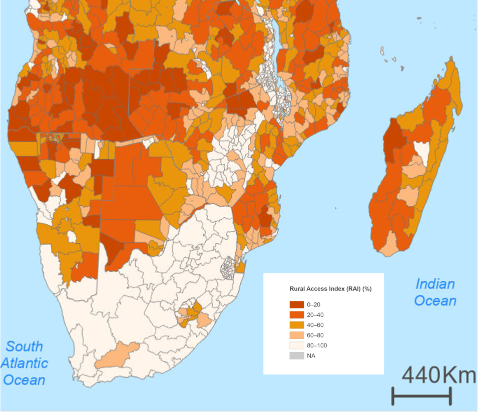
NASA’s SEDAC released the Sustainable Development Goal (SDG) Indicator 9.1.1: Rural Access Index (RAI) 2023 dataset, which measures the proportion of the rural population who live within 2 kilometers of an all-season road for a given statistical area. The SDG indicator 9.1.1 dataset provides estimates for the proportion of the rural population with access to all-season roads for 209 countries and 45,073 subnational units. The dataset is available at both national and Level 2 subnational resolutions.
The United Nation’s SDG 9 Goal is to "build resilient infrastructure, promote inclusive and sustainable industrialization and foster innovation.” According to the UN’s Sustainable Transport, Sustainable Development 2021 Interagency Report, sustainable transportation infrastructure is critical to achieving SDG 9 as it helps to eliminate poverty, promote food security, improve access to key health services, increase trade competitiveness, and bolster human rights.
SEDAC SDG 9.1.1 data access and more information
Yale Center for Earth Observation (YCEO) Surface Urban Heat Islands, v4 (2003 – 2018) Dataset Now Available
SEDAC released the Yale Center for Earth Observation (YCEO) Surface Urban Heat Islands, Version 4, (2003-2018) dataset, which includes annual, summertime, and wintertime surface urban heat island (SUHI) intensities for daytime and nighttime for more than 10,000 global urban extents. This global SUHI dataset was created using the Simplified Urban-Extent (SUE) algorithm and is available at the pixel and urban cluster-levels (i.e., at the level of larger urban agglomerations). Monthly composites are also available as urban cluster means.
YCEO surface urban heat islands data access and more information


