Improving Fire Detection in the Amazon

NASA researchers are tweaking algorithms and combining data from multiple satellites to track tropical forest fires in Brazil.
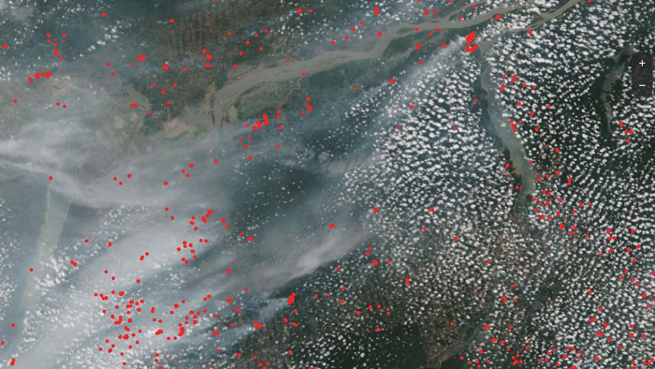
This is a satellite view of wildfires across a portion of the Amazon Rainforest. The image shows popcorn clouds and wispy streaks of fire smoke over the rainforest and winding Amazon River. Overlayed across the image are hundreds of small red dots to mark the location of fires identified by satellite sensors.
Image Caption

This image from November 13, 2023, shows the mix of clouds, smoke, and fires (red dots) across a portion the Amazon rainforest. Credit: NOAA-20/NASA Worldview/VIIRS Active Fire Product.

Fires and other significant heat sources can be detected from space by sensors aboard some of NASA’s Earth-orbiting satellites. NASA’s Fire Information for Resource Management System (FIRMS) provides these observations in near real-time, and these observations are a tremendous aid to tracking and managing fire events worldwide.

However, sometimes detecting these wildfires from space requires new approaches—such as detecting fires occurring in the dense Amazon rainforest in Brazil. The current El Niño event has brought drought-dry conditions to the usually wet Amazon rainforest. As a result, routine agricultural fires and other human ignitions have escaped into neighboring forests, triggering hundreds of creeping, low-temperature understory fires. While these fires are obviously smoky, the flames are largely hidden beneath the forest’s trees. These understory fires have a devastating impact on the rainforest—often killing 50% of the trees because Amazon species are not adapted to fire. A 2023 Earth Observatory article detailed the significance of air pollution and other problems associated with these fires.

Combating the Amazon’s low-intensity fires is difficult because they are very hard to spot from satellites or are often mislabeled by fire detection algorithms as land or other features. Dr. Shane Coffield, a researcher at NASA's Goddard Space Flight Center in Greenbelt, Maryland, is trying to address these issues by experimenting with tweaking detection algorithms and combining data from different satellites to create systems sensitive enough to reveal these hidden fires.

Blocked from View

“The main reason we can’t easily see these fires is because they are small and the canopy over them is so dense that it intercepts the fire energy and blocks it from reaching the satellite,” said Coffield.

The satellites commonly used to detect fires in the Amazon are the Suomi National Polar-orbiting Partnership (Suomi NPP) and NOAA-20 satellites equipped with the Visible Infrared Imaging Radiometer Suite (VIIRS) sensor. The VIIRS algorithm for remotely-sensing thermal anomalies is based on a similar algorithm developed for the Moderate Resolution Imaging Spectroradiometer (MODIS) instrument aboard NASA’s Terra and Aqua satellites. The MODIS instruments are nearing their mission end and the VIIRS sensors aboard Suomi NPP and NOAA-20 are becoming the primary way to detect and track global fire activity. These satellites and sensors are generally excellent at detecting global wildfires and other thermal anomalies, however, they're not ideal for detecting fire hotspots in the Amazon.

“The satellites pass over the Amazon in the early afternoon and middle of the night when fires aren’t burning at their typical peak, which is generally in the late afternoon,” said Coffield. “The sensor also has a very wide 110-degree view, and most of the time we aren’t getting a very straight down, nadir view, which is our best shot at seeing a fire in the forest understory through the dense tree canopy.”

The resolution for VIIRS data is also a fairly coarse 375-meters, which means that an actual Amazon fire front is a small fraction of a pixel—often less than 1%—making it difficult to detect.
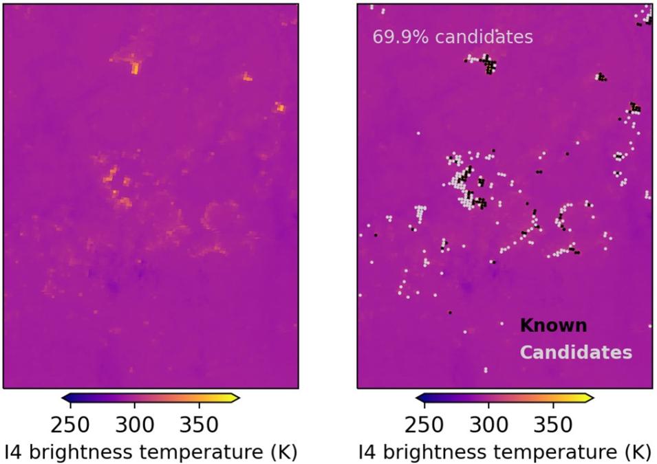
This image shows two magenta-colored panels. Each panel shows a brightness temperature scale from 250 to more than 350 degrees Kelvin. The panel on the left shows smudges of dim to brightly colored orange pixels indicating areas that are likely to be on fire. The panel on the right shows those same pixels colored black to mark the known fires and also includes gray-colored adjacent pixels that are only candidates but in reality probably part of the fire.
Image Caption

The two panels shown here are hotspot pixels detected by the VIIRS sensor. The panel on the left shows pixels positively identified as fires, with thermal radiation converted to temperatures in degrees Kelvin (K). The panel on the right shows those same pixels along with rejected candidate pixels (gray) that are adjacent to and part of the fires. Credit: NOAA-20/VIIRS Active Fire Product.

The VIIRS fire product algorithm works great for detecting a majority of the fires found around the world, especially fires that are more out in the open, such as across a mountainside or field, or that are burning intensely. The algorithm works by identifying hotspots in the VIIRS imagery, which must meet a series of thresholds to be classified as low-, nominal-, or high- confidence fires. The algorithm is intentionally conservative in flagging fires to minimize the chances of raising the alarm on a false positive. It also often masks out areas with cloud and smoke cover and doesn’t account for the angle at which the satellite is viewing the fire or canopy cover effects.

The problem is that when the algorithm is used to analyze fires in the Amazon, areas that are indeed on fire could appear dim due to dense smoke and canopy cover, sensor viewing angle, and other factors. The areas may be emitting enough thermal radiation to be labeled as candidate fire pixels, but then fail to pass the algorithm’s other tests to be flagged as a fire.

One threshold test example is that the radiated thermal energy of a candidate fire pixel has to be a certain value higher than its surrounding background pixels in order to be considered a fire. If trees block some of the radiated energy from reaching the VIIRS sensor, the hotspot could appear only slightly warmer than surrounding pixels and therefore not classified as a fire. The result is the size or occurrence of Amazon fires can be underestimated or underreported.

Peering Through the Trees

Coffield thinks the VIIRS active fire product works well for its broad intended use, but that something more customized can help detect fires in the Amazon.

“You can look at the data with your own eyes and see that the pixels that fail the tests are right next to brighter, flagged fires,” said Coffield. “So, what I’ve been doing is looking at the raw imagery and trying to figure out how to extract more information than the current VIIRS fire product.”

Coffield’s investigation has led him to develop a modified VIIRS fire detection algorithm for use over the densely covered Amazon. The algorithm is essentially refined to use lower test thresholds for flagging an area on fire.

“I’ve been getting a lot of the Level 1 VIIRS imagery data from the Earthdata Cloud for this process, which has been really exciting to me,” said Coffield. “I’ve been able to stream the data directly to the Multi-mission Algorithm and Analysis Platform (MAAP), run the analysis through Jupyter Notebooks, extract the active and candidate fire pixels, and tune the algorithm.”

Coffield says he wants to eventually use machine learning to train systems to recognize additional warm pixels in the vicinity of known fires. If warm pixels are found, then they could be smoldering fires or flaming fire fronts that are partly obscured by the forest canopy, clouds, or dense smoke.

Coffield is also working on a related effort to identify fires over the Amazon region at 30-meter resolution using data from Landsat 8, Landsat 9, and Sentinel-2 on Google Earth Engine and MAAP.

“Landsat and Sentinel data provide a much higher resolution to spot small fires that VIIRS would never detect,” said Coffield.

However, the downside of Landsat and Sentinel data is that they are available only every two to three days compared to the twice-a-day download of new VIIRS data from both Suomi NPP and NOAA-20.

“In the future, we hope to have a fleet of CubeSats that provide high resolution data many more times throughout the day,” said Coffield.

For now, Coffield is already putting his new algorithm to valuable use. Each day he’s analyzing the current fire situation in Brazil and working to provide fire managers and research colleagues there with a daily download of suspected new fires. Through clever thinking and NASA’s Earth science data, Coffield is helping everyone to see through the smoke and between the trees to spot and respond to the Amazon’s unseen but very damaging fires.

Details

Last Updated

Published