Hotspot Detection Limitations
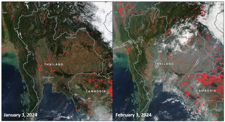
As Tanpipat notes in "Active Fire Monitoring of Thailand and Upper ASEAN by Earth Observation Data: Benefits, Lessons Learned, and What Still Needs to Be Known," a chapter in the 2023 book Vegetation Fires and Pollution in Asia: "Users sometimes need help understanding the caveats and limitations of using satellite-derived active fire information. The MODIS and VIIRS instruments are on polar-orbiting satellites, meaning active fires are only detected as the satellite passes overhead. Because they are optical instruments, clouds, smoke, and thick haze can obscure active fire detection. To this end, the number of active fire hotspots detected does not reflect the total picture of smoke haze, which affects air quality. [Further,] active fires detected in other countries mean additional sources of smoke haze that can be transported long distances to another country. Factors such as wind and air pressure are involved in the movement of smoke haze."
Acknowledging the limitations of MODIS and VIIRS hotspot detection and active fire data is not just an academic exercise. The accuracy of the results of the MODIS and VIIRS field campaigns prompted the Thai government to use the number of active fires detected by FIRMS during a fire season as key performance indicators (or KPIs) to evaluate the effectiveness of DNP and RFD fire control efforts. However, because the presence of clouds, smoke, and thick haze can negatively impact the ability of these sensors to detect active fires and burned areas, the annual fire season statistics from the DNP, RFD, and GISTDA may not agree.
To address this discrepancy, Tanpipat advised the agencies to use the MODIS Burned Area Product (MCD64A1) to identify fire season trends and then worked with Diane Davies, operations manager for NASA's Land, Atmosphere Near real-time Capability for Earth observations (LANCE), to ensure the product updates more frequently.
"[Thai government agencies] usually use burned area products from Landsat 8 and 9 and the ESA (European Space Agency) Sentinel satellites, but so far, they do it very slowly once every fire season. They plan to improve the frequency later," Tanpipat said. "Also, they have only 10-years of records and not for the whole country. So, if they would like to look back on the two decades of burned area history, they need to use MODIS 500m Burned Area Products to see any trends. They can look at Earth Map, which updates automatically when products are available, but FIRMS takes at least six months to update, which is too late. This year, I worked with Diane Davies to update it to last month."
FIRMS Future in the Lower Mekong River Region
Despite these limitations, Tanpipat says FIRMS has become an integral tool for monitoring active fires and smoke haze in the Lower Mekong River Region.
"The control, management, and mitigation measures used in Thailand are expanding and people all over the Lower Mekong River Region are using FIRMS," he said. "It is an international treasure for forest fire control and management."
NASA's Davies is not surprised that the use of FIRMS is expanding throughout the region.
"FIRMS provides tangible, real-world benefits to a variety of users around the world, so it's no surprise that we are seeing increasing numbers of users in the Lower Mekong River Region pull the active fire data via FIRMS's web services," Davies said. "The DNP, RFD, and GISTDA use of active fire data is a perfect example of this. They routinely pull data from FIRMS into a customized application and add value to it by combining it with other geospatial data, which enables them to expand their resources and be more effective on the ground."
Learn More
Data Tool in Focus: Fire Information for Resource Management System
Webinar: Discover Enhanced Wildfire System Capabilities with NASA's FIRMS (October 2023)


