Earth Science Data Roundup: October 2024

A summary of datasets, products, and resources released by NASA’s Distributed Active Archive Centers (DAACs) in September 2024.

Atmospheric Science Data Center (ASDC)

Transport and Atmospheric Chemistry near the Equator (TRACE) Campaign Datasets Released

A suite of Level 2, 3, and 4 data products from the Transport and Atmospheric Chemistry near the Equator (TRACE) suborbital campaign are available at NASA's ASDC. TRACE comprised two missions: TRACE-Atlantic (TRACE-A) and TRACE-Pacific (TRACE-P).

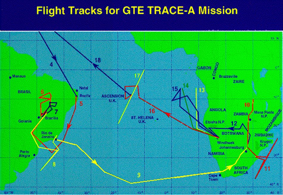
TRACE-A took place from September to October 1992, with flights extending from Brazil to southern Africa. TRACE-P took place from February to April 2001, with flights over the northwestern Pacific. Both campaigns utilized the NASA DC-8 aircraft to collect measurements, while TRACE-P also utilized NASA's P-3B aircraft.

This map from the TRACE-Atlantic suborbital campaign shows the flight paths between Africa and South America flown by the aircraft used in the campaign.
Caption

Colored lines indicate flight paths taken during the TRACE-A mission, which took place from September to October 1992 with flights extending from Brazil to southern Africa. Credit: NASA.

The objectives of TRACE-A were to study the contribution of photochemical and meteorological features to enhanced ozone concentrations observed over the tropical Atlantic Ocean and to characterize and quantify the source and transport of primary and secondary ozone precursors associated with biomass burning in South America and southern Africa. The goals of TRACE-P were to characterize the Asian outflow in terms of chemical composition over the northwestern Pacific Ocean, including quantifying the sources and emissions and characterizing the chemical evolution of the outflow (how the chemicals change as the airmass moves away from the continent) and assess the major factors influencing this evolution.

For TRACE data access and more information, visit the TRACE-A and TRACE-P landing pages.

Global Hydrometeorology Resource Center Distributed Active Archive Center (GHRC DAAC)

Cloud Radar System (CRS) IMPACTS Dataset Now Available

The Cloud Radar System (CRS) IMPACTS dataset consists of calibrated radar reflectivity, Doppler velocity, linear depolarization ratio, and normalized radar cross-section estimates collected by the Cloud Radar System (CRS) aboard the NASA ER-2 high-altitude research aircraft. These data were gathered during the Investigation of Microphysics and Precipitation for Atlantic Coast-Threatening Snowstorms (IMPACTS) field campaign, a three-year sequence of winter season deployments conducted to study snowstorms over the U.S. Atlantic Coast (2020-2023). The CRS IMPACTS dataset files are available from January 25, 2020, through February 28, 2023, in HDF-5 format.

Access CRS IMPACTS data and more information

Goddard Earth Sciences Data and Information Services Center (GES DISC)

OMI version 4 OMAERUV Data Product Released

NASA's GES DISC released the Aura Ozone Monitoring Instrument (OMI) Level-2 near UV Aerosol data product, OMAERUV (version 004). The OMAERUV product contains Aerosol Optical Depth, Aerosol Single Scattering Albedo, Absorption Optical Depth, UV Aerosol Index, and Aerosol Optical Depth over clouds at three wavelengths (354, 388, and 500 nm), and includes ancillary and geolocation parameters. OMAERUV files are available in netCDF format, and each file contains data from the daylit portion of an orbit (~53 minutes).

Access the OMAERUV data product and more information

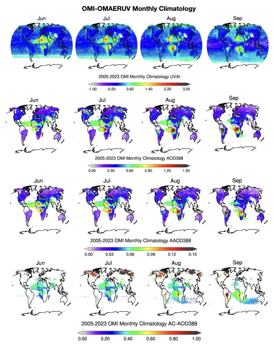
This graphic shows a series of maps offering visualizations of UV Aerosol Index, Aerosol Optical Depth, Aerosol Absorption Optical Depth, and Above-Cloud Aerosol Optical Depth global monthly data derived from the long-term (2005-2023) OMI-OMAERUV Collection 004 aerosol product,
Image Caption

This graphic shows global, monthly climatology maps offering visualizations, at 0.5-degree grid resolution, of UV Aerosol Index (UVAI), Aerosol Optical Depth (AOD), Aerosol Absorption Optical Depth (AAOD), and Above-Cloud Aerosol Optical Depth (AC-AOD) data (the last three parameters at 388 nanometers) derived from the long-term (2005-2023) OMI-OMAERUV Collection 004 aerosol product. Credit: NASA's GES DISC.

OMI Version 004 Level 2 Cloud Data Product Now Available

The OMI Version 004 Level 2 Cloud Data Product (OMCLDRR) provides global effective cloud pressure and effective cloud fraction data. The new version now uses OMI Level 1B Collection Version 4 data as inputs and contains many ancillary and derived parameters, terrain, and geolocation information, solar and platform viewing angles, and quality flags. OMCLDRR files are available in HDF-EOS5 format.

Access the OMCLDRR data product and more information

Land Processes DAAC (LP DAAC)

Monthly and Yearly MEaSUREs GWELD Version 3.2 2005 Epoch Data Products

NASA's LP DAAC released the 2005 epoch of the monthly and yearly NASA Making Earth System Data Records for Use in Research Environments (MEaSUREs) Global Web-Enabled Landsat Data (GWELD) Version 3.2 product at a 30 meter spatial resolution. The GWELD v3.2 2005 epoch contains data from January 1, 2004, through December 31, 2006. These new data are generated from Landsat 5 Thematic Mapper (TM) and Landsat 7 Enhanced Thematic Mapper Plus (ETM+) images in the USGS Landsat Collection 2 archive. GWELD products provide nadir bidirectional reflectance distribution function-adjusted reflectance for the reflective wavelength bands and top of atmosphere brightness temperature for the thermal bands.

Access GWELD data products and more information

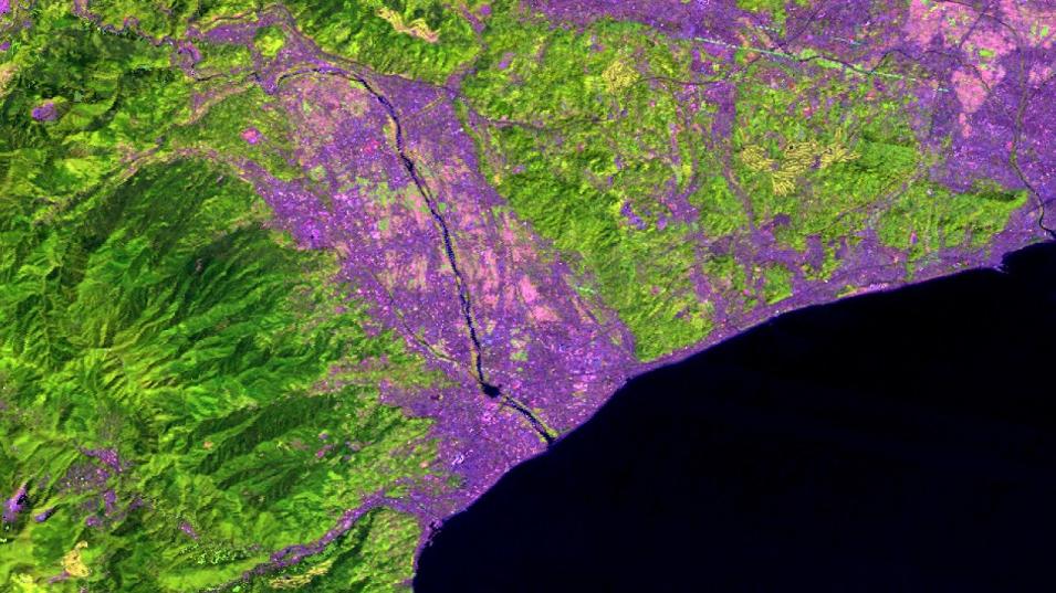
A visualization of yearly surface reflectance Landsat data (band 5-4-3) over Odawara, Japan. The data, which were acquired in 2005, are from the from the Global Web-Enabled Landsat Data version 3.2 product.
Image Caption

Image from the Global Web-Enabled Landsat Data (GWELD) v3.2 2005 product showing Odawara, Japan. Credit: NASA's LP DAAC.

EMIT Mineral Identification and Band Depth and Uncertainty Now Available in AppEEARS

Version 3.62 of the Application for Extracting and Exploring Analysis Ready Samples (AppEEARS) adds a new dataset from the Earth Surface Mineral Dust Source Investigation (EMIT) platform: EMIT Level 2B Estimated Mineral Identification and Band Depth and Uncertainty 60-meter (EMITL2BMIN).

The EMITL2BMIN product was generated to support the EMIT mission objectives of constraining the sign of dust-related radiative forcing. The core focus of this work are the minerals calcite, chlorite, dolomite, goethite, gypsum, hematite, illite+muscovite, kaolinite, montmorillonite, and vermiculite. Additional minerals are included in the product for transparency but were not the focus of this product. Further validation is required to use these additional surface mineral maps, particularly in the case of resource exploration. In addition, the separation of minerals with similar spectral features, such as a fine-grained goethite and hematite, is an area of active research.

Access the EMITL2BMIN data product and more information

GEDI Version 2 Migrates to NASA’s Earthdata Cloud

The Global Ecosystem Dynamics Investigation (GEDI) Version 2 Level 1B Geolocated Waveform (GEDI01_B), Level 2A Elevation and Height Metrics (GEDI02_A), and Level 2B Canopy Cover and Vertical Profile Metrics (GEDI02_B) data products are now available in NASA's Earthdata Cloud. The migration of these products allows for continued download of data files via HTTPS in Earthdata Search and offers a new option for working with these data in the cloud via Simple Storage Service (S3) direct access.

GEDI data products distributed from NASA’s Earthdata Cloud have a different LP DAAC provider and data product concept_ids. The LP DAAC will be updating scripts and tutorials from the LPDAAC_ECS provider to the LPCLOUD provider along with the following concept_id updates (users will need to change their scripts accordingly):

  • GEDI01_B.002 from “C1908344278-LPDAAC_ECS” to “C2142749196-LPCLOUD”
  • GEDI02_A.002 from “C1908348134-LPDAAC_ECS” to “C2142771958-LPCLOUD"
  • GEDI02_B.002 from “C1908350066-LPDAAC_ECS” to “C2142776747-LPCLOUD"

More information about GEDI Earthdata Cloud migration

Level 1 and Atmosphere Archive and Distribution System DAAC (LAADS DAAC)

Level-3 Cloud Properties Data Product Suite Now Available

NASA's (LAADS DAAC) released the Level-3 Cloud Feedback Model Intercomparison Project (CFMIP) Observation Simulator Package (COSP) suite of data products.

The suite comprises cloud property (CLDPROP) data from three instruments: the Moderate Resolution Imaging Spectroradiometer (MODIS) aboard NASA's Aqua platform and the Visible Infrared Imaging Radiometer Suite (VIIRS) aboard the joint NASA-NOAA Suomi National Polar-orbiting Partnership (Suomi NPP, which is designated in the product suite as SNPP) and NOAA-20 platforms.

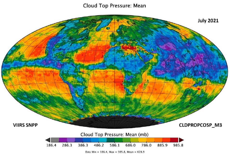
This graphic shows a visualization of mean cloud top pressure data (i.e., observations of  the atmospheric pressure at the top of a cloud) in millibars (mb, a unit of pressure used to describe atmospheric conditions) for July 2021.
Image Caption

Global mean cloud top pressure data (observations of the atmospheric pressure at the top of a cloud) in millibars (mb) for July 2021 from the VIIRS Suomi NPP (SNPP) CLDPROPCOSP Level 3 monthly (M3), 1x1 degree grid data product. Orange and red colors indicate areas of higher pressure; blue and purple colors indicate areas of lower pressure. The data product contains aggregated cloud mask, cloud top, and cloud-optical retrieval data over daily and monthly timeframes using the VIIRS/Suomi NPP Level 2 CLDPROP product as an input. Credit: NASA's LAADS DAAC.

The CLDPROPCOSP product suite contains six datasets derived from three Level 2 MODIS and VIIRS CLDPROP data streams at daily and monthly timeframes:

  • MODIS/Aqua CLDPROPCOSP Level 3 daily 1x1 degree grid
  • MODIS/Aqua CLDPROPCOSP Level 3 monthly, 1x1 degree grid
  • VIIRS/SNPP CLDPROPCOSP Level 3 daily, 1x1 degree grid
  • VIIRS/SNPP CLDPROPCOSP Level 3 monthly, 1x1 degree grid
  • VIIRS/NOAA20 CLDPROPCOSP Level 3 daily, 1x1 degree grid
  • VIIRS/NOAA20 CLDPROPCOSP Level 3 monthly, 1x1 degree grid

The start date for the CLDPROPCOSP product data record varies based on the input platform used. For MODIS/Aqua, the data record begins in 2002 and continues to the present (or until the instrument data become unviable). For VIIRS/Suomi NPP, the data record begins in 2012 and continues to the present. For VIIRS/NOAA-20, the data record begins in 2018 and continues to the present.

Access CLDPROPCOSP data and learn more about this product suite in a NASA Earthdata news article.

National Snow and Ice Data Center DAAC (NSIDC DAAC)

Updated Snow Water Equivalent and Snow Depth Dataset

The temporal coverage for the Daily 4 km Gridded Snow Water Equivalent and Snow Depth from Assimilated In-Situ and Modeled Data over the conterminous United States, Version 1 dataset has been been extended to September 30, 2023, by adding the latest water year.

Access the updated snow water equivalent and snow depth dataset and more information

Level 1B SMAP Reflectometry, Version 1 Dataset Now Available

The Level 1B SMAP Reflectometry, Version 1 dataset represents the first full polarimetric Global Navigation Satellite System Reflectometry (GNSS-R) dataset derived from the Soil Moisture Active Passive (SMAP) mission radar. The main parameters are the normalized Stokes parameters, total power normalized bistatic radar cross-section, and reflectivity. The dataset comprises a full reconstruction of Earth's surface polarimetric values, with approximately 3,200 observations per day and about 1,200,000 per year.

Access the SMAP GNSS-R dataset and more information

Updated MODIS/Terra Snow Cover, Grain Size, and Dust Radiative Forcing Dataset

The temporal coverage of the Near Real-Time Moderate Resolution Imaging Spectroradiometer (MODIS)/Terra Level 3 Global Daily 500-meter Sinusoidal Grid Snow Cover, Grain Size, and Dust Radiative Forcing, Version 1 dataset has been extended to include files from April 1, 2024 through June 30, 2024.

Access the updated MODIS/Terra snow dataset and more information

Updated ICESat-2 Sea Ice Thickness Dataset

The temporal coverage of the Ice, Cloud, and land Elevation Satellite-2 (ICESat-2) Level 4 Monthly Gridded Sea Ice Thickness, Version 3 dataset has been extended by adding the monthly files from September 2023 through April 2024.

Access the updated ICESat-2 sea ice thickness dataset and more information

Updated Sea Ice Concentrations Dataset from Nimbus-7 SMMR and DMSP SSM/I-SSMIS Passive Microwave Data

The Sea Ice Concentrations from Nimbus-7 Scanning Multichannel Microwave Radiometer (SMMR) and Defense Meteorological Satellite Program (DMSP) Special Sensor Microwave/Imager (SSM/I)-SSMIS Passive Microwave Data, Version 2 dataset has been updated through March 31, 2024. This dataset is generated from brightness temperature data and provides a consistent time series of sea ice concentrations spanning the coverage of several passive microwave instruments. The data are provided in the polar stereographic projection at a grid cell size of 25 x 25 kilometers.

Access the updated Nimbus-7 sea ice concentrations dataset and more information

New SnowEx17 Dataset

The SnowEx17 GPR and Lidar-Derived Snowpack Relative Permittivities and Densities, Version 1 dataset is now available at NASA's NSIDC DAAC. This dataset contains the results of 1 gigahertz (GHz) ground-penetrating radar (GPR) surveys conducted in Grand Mesa, Colorado. Data include two-way travel time, lidar-measured snow depth, calculated snow water equivalent, calculated snow density, and calculated relative permittivity. The dataset's temporal range spans from February 8 to 25, 2017.

Access the new SnowEx17 dataset and more information

Updated MEaSUREs Greenland Annual/Quarterly/Monthly Ice Sheet Velocity Mosaics Datasets

The MEaSUREs Greenland Annual Ice Sheet Velocity Mosaics from SAR and Landsat, Version 5; Greenland Quarterly Ice Sheet Velocity Mosaics from Synthetic Aperture Radar (SAR) and Landsat, Version 5; and Greenland Monthly Ice Sheet Velocity Mosaics from SAR and Landsat, Version 5 datasets have been updated. The annual product temporal coverage has been extended to November 30, 2023, and the quarterly and monthly temporal coverages have been extended to May 31, 2024.

These datasets, which are part of NASA's Making Earth System Data Records for Use in Research Environments (MEaSUREs) Program, consist of annual, quarterly (three-month interval), and monthly ice velocity mosaics for the Greenland Ice Sheet. The data are derived from SAR data obtained by TerraSAR-X/TanDEM-X and Sentinel-1A and -1B platforms as well as from optical imagery acquired by Landsat 8 and Landsat 9.

Access the updated Greenland Ice Sheet datasets and more information

New Greenland Glacial and Fast Ice Distributions Dataset

The Glacial and Fast Ice Distributions in Southeast Greenland Fjords, Version 1 dataset provides spatial distributions of fast ice and glacial ice in eight fjords spanning the Southeast Greenland coast: Nansen, Kangerlusruaq, Ikertivaq, Skjoldungen, Tingmiarmiut, Napasorsvaq, Anoritup, and Kangerlluluk. Temporal coverage is discontinuous, depending on the availability and quality of images.

Access the new Greenland fjord dataset and more information

SnowEx23 CRREL Ground Penetrating Radar Datasets Released

The SnowEx23 CRREL Ground Penetrating Radar, Version 1 and SnowEx23 CRREL Ground Penetrating Radar Raw, Version 1 datasets contain the results of 1 gigahertz (GHz) ground-penetrating radar surveys conducted in Alaska and the corresponding raw data. Temporal coverage spans from March 8 to 15, 2023.

Access SnowEx23 CRREL datasets and more information

Oak Ridge National Laboratory DAAC (ORNL DAAC)

Version 2 of the GEDI Level 4C Footprint Level Waveform Structural Complexity Index Released

Version 2 of the Global Ecosystem Dynamics Investigation (GEDI) Level 4C Footprint Level Waveform Structural Complexity Index dataset contains predictions of the Waveform Structural Complexity Index and estimates of prediction intervals for each footprint estimate at 95% confidence. In this version, the granules are in sub-orbits and the data, which are provided in HDF5 format, cover the period April 17, 2019, to March 16, 2023.

Access the GEDI Level 4C, Version 2 dataset and more information
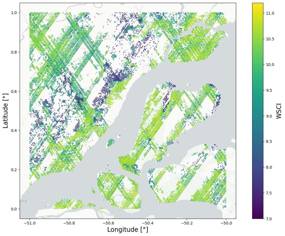
Shown here is a a subset of GEDI Level 4C data featuring Waveform Structural Complexity Index (WSCI) predictions over the eastern Amazon.
Image Caption

This graphic shows a subset of the Waveform Structural Complexity Index (WSCI) predictions from the GEDI Level 4C footprint product over the eastern Amazon. Brighter colors indicate greater structural complexity; darker colors indicate lower complexity. Credit: NASA's ORNL DAAC.

New Atmospheric Tomography Mission (ATom) Dataset

NASA's ORNL DAAC released the ATom: Development of Cloud Indicator Algorithm Using Airborne Observations from CAPS dataset, which is the basis for the development of the Cloud Indicator, a novel algorithm that automatically detects and classifies measurement periods inside clouds. The Cloud Indicator algorithm was developed based on particle size distribution measurements from a second-generation Cloud, Aerosol, and Precipitation Spectrometer (CAPS) combined with measurements of relative humidity and temperature from other instruments, to automatically detect flight sequences in clouds and classify the cloud type. Data are provided in netCDF format.

Access the ATom CAPS dataset and more information

New Great Slave Lake Aboveground Biomass Dataset

The Aboveground Biomass from SAR, Great Slave Lake Region, Northwest Territories (NWT), 2019 dataset holds aboveground biomass (ABG) estimates for areas in the Great Slave Lake Region in Canada's NWT for 2019. The ABG estimates are from L-band SAR data obtained from the JAXA (Japan Aerospace Exploration Agency) Advanced Land Observing Satellite-2 (ALOS-2/PALSAR-2) and supplemented with data from NASA's airborne Uninhabited Aerial Vehicle SAR (UAVSAR) instrument. SAR data were collected from 2017 to 2021. The estimates are provided in 20 megagrams per hectare (Mg/ha)-1 bins at 100-meter resolution in cloud optimized GeoTIFF (COG) format.

Access the new Great Slave Lake biomass dataset and more information

New ABoVE Arctic Alaska Rivers Dataset

The Seasonal Dissolved Gases and Isotopes in Arctic Alaska Rivers Dataset from the Arctic-Boreal Vulnerability Experiment (ABoVE) provides dissolved carbon dioxide (CO2) and methane (CH4) concentrations alongside their stable and radiocarbon isotopic compositions within the Arctic Sagavanirktok and Kuparuk River watersheds located on the North Slope of Alaska. The data were collected during the spring, fall, and summer seasons in 2022 and are provided in comma separated values (CSV) format.

Access the new ABoVE Alaska rivers dataset and more information

Impacts of Wildfires on Boreal Forest Ecosystem Carbon Dynamics Dataset Now Available

The Impacts of Wildfires on Boreal Forest Ecosystem Carbon Dynamics dataset contains simulations of net primary production, heterotrophic respiration, net ecosystem production, and soil temperature data in North American boreal forests from 1986 to 2020. Data sources included historical fire sources and Landsat data. The delta Normalized Burn Ratio, which can be used to represent burn severity for a fire, was calculated for each fire over the time period. The interactions between canopy, fire, and soil thermal dynamics were modeled using a soil surface energy balance model incorporated into a previous Terrestrial Ecosystem Model.

Access the carbon dynamic dataset and more information

Carbon Monitoring System Global Wetland Methane Emissions and Uncertainty Dataset Released

The Global 0.5-deg Wetland Methane Emissions and Uncertainty (WetCHARTs v1.3.3) dataset from NASA's Carbon Monitoring System (CMS) provides global monthly wetland methane emission estimates at 0.5 by 0.5-degree resolution from January 1, 2001, to August 31, 2022. The estimates were derived from an ensemble of multiple terrestrial biosphere models, wetland extent scenarios, and temperature dependencies that encompass the main sources of uncertainty in wetland methane emissions. There are 18 model configurations, and the data are provided in netCDF format.

Access the CMS methane emissions dataset and more information

New African Land Use and Urban Land Cover Dataset

The Annual Land Use and Urban Land Cover: Ethiopia, Nigeria, and South Africa, 2016-2020 dataset provides a two-tier annual Land Use (LU) and Urban Land Cover (LC) product suite over Ethiopia, Nigeria, and South Africa across a 5-year period from 2016 to 2020. Remote sensing data sources were used to create 30-meter resolution LU maps (Tier-1), which were then used to delineate urban boundaries for 10-meter resolution LC classes (Tier-2). Tier-1 LU maps are based on the 30-m Landsat time series; Tier-2 urban LC maps are based on the 10-m Sentinel-2 time series. The data are provided in cloud optimized GeoTIFF (COG) format.

Access the African land use and land cover dataset and more information

Delta-X: NUMAR Dataset Released

The Delta-X: NUMAR Predictive Model for Marsh Accretion Rates and Chemical Properties dataset provides input data and model code to run the Marsh Accretion Rates (NUMAR) process model used to predict soil accretion rates and chemical properties for marsh sites in the Mississippi River Delta. The dataset provides Python code, input data in comma separated values (CSV) format, and documentation for installing and running the model in Portable Document Format (PDF).

Access the Delta-X: NUMAR dataset and more information

Delta-X: AirSWOT Level 3 Water Surface Elevations Dataset Now Available

The AirSWOT Level 3 Water Surface Elevations, Mississippi River Delta, Louisiana, 2021, Version 2 dataset from the Delta-X airborne campaign contains water surface elevations at selected point locations generated from AirSWOT data collected during the spring and fall 2021 Delta-X deployments over the Atchafalaya and Terrebonne basins in Louisiana. AirSWOT is an airborne mission that uses near-nadir wide-swath Ka-band radar interferometry to measure water-surface elevation and produce continuous gridded elevation data.

The Level 3 data were created by masking land areas out of the AirSWOT Level 2 products, then filtering and averaging to the AirSWOT heights to produce water surface elevations at selected points throughout the scene. AirSWOT data are useful for calibrating elevation and slopes along the main channels as well as for tying observations to open ocean tidal conditions. Data from AirSWOT also provide calibration and validation for data acquired by the Surface Water and Ocean Topography (SWOT) platform. The data are provided in comma-separated values (CSV) format.

Access the Delta-X: AirSWOT Level 3 water surface elevation data and more information

Delta-X: AirSWOT Level 2 Geocoded Water Surface Elevation Dataset Released

The AirSWOT Level 2 Geocoded Water Surface Elevation, Mississippi River Delta, Louisiana, 2021, Version 3 dataset from the Delta-X airborne campaign contains Level 2 AirSWOT geocoded products, including estimated water surface elevation. Data were collected during the Delta-X airborne campaign over the Atchafalaya and Terrebonne basins of the Mississippi River Delta, in Louisiana. Flights occurred from March 26 to April 18, 2021, and from August 21 to September 12, 2021. This dataset contains cloud optimized GeoTIFF rasters in UTM map coordinates for each flight line. In addition, a text file provides basic metadata, including flight line ID, start and end UTC times of data acquisition, processor version number, and the date and time of different processing stages.

Note: This Version 3 dataset provides updated data files due to an updated Calumet survey that changed the water level by 0.138 meters. This resulted in all the AirSWOT water levels changing by that same amount.

Access the Delta-X: AirSWOT Level 2 geocoded water surface elevation data and more information

Physical Oceanography DAAC (PO.DAAC)

Three CYGNSS Level 3 Datasets Released

NASA's PO.DAAC released three Cyclone Global Navigation Satellite System (CYGNSS) data products:

  • The CYGNSS Level 3 MRG Science Data Record Version 3.2.1 combines the L2 Fully Developed Seas (FDS) and Young Seas Limited Fetch (YSLF) winds and eliminates the need to choose between them depending on sea state development and the proximity to storms; data are available from August 1, 2018, to present with an approximate 6-day latency
  • The CYGNSS Level 3 MRG Science Data Record Near Real-Time Version 3.2.1 dataset has an approximate latency of 2 to 24 hours; data are available from June 1, 2024, to present
  • The CYGNSS Level 3 Daily RWAWC Watermask Version 3.2 dataset from the University of California Berkeley is derived from Version 3.2 of the CYGNSS Level 1 SDR dataset and provides daily binary inland surface water classification data at a 0.01-degree (~1x1 kilometer) resolution with an approximate 6-day latency; data are available from August 1, 2018, to present

These CYGNSS data products are provided in netCDF-4 data format.

Access the new CYGNSS Level 3 data products and more information

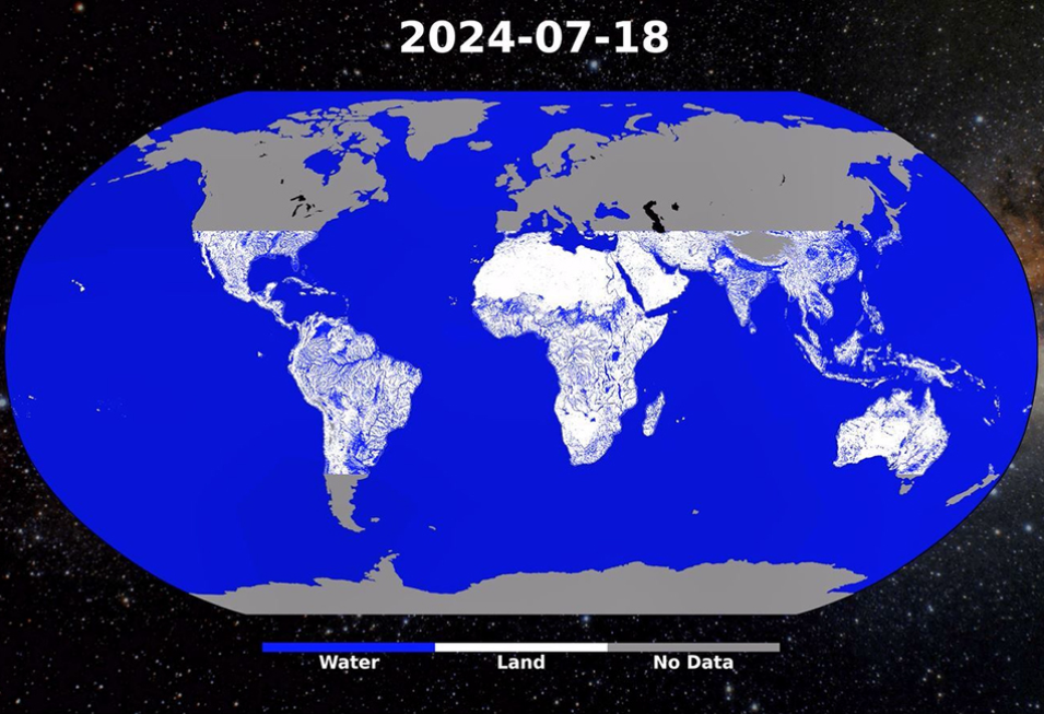
global image showing water bodies for latitudes between the tropics of cancer and capricorn
Image Caption

Daily watermask for July 18, 2014, produced using the CYGNSS Level 3 Daily Watermask Version 3.2 dataset, developed by CYGNSS investigators in the Department of Civil and Environmental Engineering at the University of California, Berkeley.

Updated GRACE-FO Datasets Now Available

NASA's PO.DAAC released the RL06.3 update to several GRACE-Follow On (GRACE-FO) datasets produced by NASA's Jet Propulsion Laboratory, including Level 2 gravity anomalies and Level 3 (including mass concentration, MASCON) ocean bottom pressure and terrestrial water mass anomalies.

The data provide global coverage and are reported as monthly averages and are available from May 2018 onward with forward streaming. The new release is based on an update to the Level 2 RL06.1 products. RL06.3 differs from RL06.1 only in the Level-1B accelerometer transplant data that are used for the GF2 platform. The Level 3 products are then derived from the new Level 2 data.

Access the updated GRACE-FO datasets and more information

Back-fill of SMAP RSS Sea Surface Salinity V6.0 Validated Datasets Completed

NASA's PO.DAAC has completed the back-fill processing for the version 6.0 Soil Moisture Active Passive (SMAP) Sea Surface Salinity (SSS) validated datasets from Remote Sensing Systems (RSS), sponsored by the NASA Ocean Salinity Science Team. The datasets now span from May 25, 2015, to present.

Access the SMAP RSS SSS datasets and more information

Details

Last Updated

Published

Data Center/Project

Atmospheric Science Data Center (ASDC)
Goddard Earth Sciences Data and Information Services Center (GES DISC)
Global Hydrometeorology Resource Center DAAC (GHRC DAAC)
Level 1 and Atmosphere Archive and Distribution System DAAC (LAADS DAAC)
Land Processes DAAC (LP DAAC)
National Snow and Ice Data Center DAAC (NSIDC DAAC)
Oak Ridge National Laboratory DAAC (ORNL DAAC)
Physical Oceanography DAAC (PO.DAAC)