Level-3 Cloud Properties Data Product Suite Now Available

This new suite of products provides data on cloud properties for detecting climate trends and enhancing models.

NASA's Level-1 and Atmosphere Archive and Distribution System Distributed Active Archive Center (LAADS DAAC) released the Level-3 Cloud Feedback Model Intercomparison Project (CFMIP) Observation Simulator Package (COSP) suite of data products.

The objective of the product suite is to advance research on detecting climate trends, including those related to clouds, and facilitate the comparison of climate models and satellite observations. The suite is referred to collectively by the product's short name: CLDPROPCOSP.

The suite comprises cloud property (CLDPROP) data from three instruments: the Moderate Resolution Imaging Spectroradiometer (MODIS) aboard NASA's Aqua satellite and the Visible Infrared Imaging Radiometer Suite (VIIRS) aboard both the joint NASA-NOAA Suomi National Polar-orbiting Partnership (Suomi NPP, which is designated in the product suite as SNPP) and NOAA-20 satellites.

In addition to providing cloud mask, cloud top, and cloud optical retrieval data over daily and monthly timeframes, the Level-3 CLDPROPCOSP products offer a set of custom cloud-related parameters, use specific dataset definitions for better comparison with climate model output, and are available in netCDF4 format. The daily products are tagged D3, which is short for Level-3 daily, and the monthly products are tagged M3, to denote Level-3 monthly.

"Remote satellite observations provide a valuable source of information for understanding errors in climate models," state the authors of the CLDPROPCOSP user guide. "Retrievals of particle size, in particular, offer a unique view of cloud-aerosol interactions."
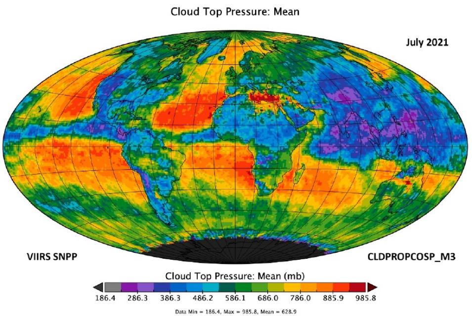
This graphic shows a visualization of mean cloud top pressure data (i.e., observations of  the atmospheric pressure at the top of a cloud) in millibars (mb, a unit of pressure used to describe atmospheric conditions) for July 2021.
Image Caption

Global mean cloud top pressure data (observations of the atmospheric pressure at the top of a cloud) in millibars (mb) for July 2021 from the VIIRS Suomi NPP (SNPP) CLDPROPCOSP Level 3 monthly (M3), 1x1 degree grid data product. Orange and red colors indicate areas of higher pressure; blue and purple colors indicate areas of lower pressure. The data product contains aggregated cloud mask, cloud top, and cloud-optical retrieval data over daily and monthly timeframes using the VIIRS/Suomi NPP Level 2 CLDPROP product as an input. Credit: NASA's LAADS DAAC.

The Product Suite

The CLDPROPCOSP product suite contains six datasets derived from three Level 2 MODIS and VIIRS CLDPROP data streams at daily and monthly timeframes:

The start date for the CLDPROPCOSP product data record varies based on the input satellite platform used. For MODIS/Aqua, the data record begins in 2002 and continues to the present (or until the instrument data become unviable). For VIIRS/Suomi NPP, the data record begins in 2012 and continues to the present. For VIIRS/NOAA-20, the data record begins in 2018 and continues to the present.

Data Access

The new Level-3 COSP cloud product suite is available through NASA's Earthdata Search as well as through LAADS DAAC dataset landing pages. The data are also available in NASA's Earthdata Cloud, which gives users the opportunity to access and process large quantities of data and promotes opportunities for innovation around new services such as sequencing data to aid machine learning and artificial intelligence and supporting NASA's Open-source Project for a Network Data Access Protocol (OPeNDAP).

The Cloud Feedback Model Intercomparison Project (CFMIP)

The CFMIP is a World Climate Research Program-endorsed project that aims to improve the understanding and evaluation of clouds, cloud feedbacks, and their coupling with circulation, precipitation, and climate. The COSP system was developed by the CFMIP to facilitate the use of data from NASA's afternoon constellation of Earth observation satellites (A-Train) in numerical models.

Learning Resources

Details

Last Updated

Published

Data Center/Project

Level 1 and Atmosphere Archive and Distribution System DAAC (LAADS DAAC)