Updates to ICESat-2 Datasets
The Advanced Topographic Laser Altimeter System (ATLAS)/Ice, Cloud, and land Elevation Satellite-2 (ICESat-2) Level 2A Global Geolocated Photon Data (ATL03) Version 6 dataset, the ATLAS/ICESat-2 Level 2A Normalized Relative Backscatter Profiles (ATL04) Version 6 dataset, and the higher-level products derived from the ATL03 and ATL04 data products have been updated. All products for Version 6 are now referenced to ITRF2014. Note: The Land-Ice-Height-derived products (ATL11, ATL14, and ATL15) have a different reprocessing workflow and will be processed at a later time.
Access updated ICESat-2 datasets and more information
VIIRS Snow and Sea Ice Datasets to Cease Forward Processing
VIIRS Version 1 (Collection 1) snow and sea ice datasets will cease forward processing on June 17, 2024. Although Version 1 data will remain available for download for several months, NASA's NSIDC DAAC strongly encourages users to transition to VIIRS Version 2 (Collection 2) prior to June 17, 2024.
More information about the end to VIIRS Version 1 (Collection 1) forward processing
SMAP L4 Data Reprocessed
Level 4 datasets from NASA's Soil Moisture Active Passive (SMAP) mission were reprocessed from November 1, 2023, through the present after an issue was discovered with the Integrated Multi-satellitE Retrievals for GPM (IMERG)-Late precipitation input after the Global Precipitation Measurement (GPM) mission orbit boost on November 7 to 8, 2023. The reprocessed data files have the science version ID (SVID) Vv7031 (the L4 SM products) and Vv7041 (the L4 carbon product) and now use the NOAA Climate Prediction Center "Unified" (CPCU) precipitation inputs instead of IMERG-Late precipitation inputs. Data from the older versions (Vv7030 and Vv7040) from November 1, 2023, through present are considered "bad" and users are strongly encouraged to download the newer files.
More information about the reprocessing of SMAP Level 4 data
Oak Ridge National Laboratory DAAC (ORNL DAAC)
New GEDI Level 4C Dataset
The Global Ecosystem Dynamics Investigation (GEDI) Level 4C Footprint Level Waveform Structural Complexity Index, Version 2 dataset is now available at NASA's ORNL DAAC. This dataset contains GEDI Level 4C Version 2 predictions of the Waveform Structural Complexity Index (WSCI) and estimates of prediction intervals for each footprint estimate at 95% confidence. The data are provided in HDF5 format and the granules are in sub-orbits.
The GEDI instrument is mounted on the International Space Station, and consists of three lasers producing a total of eight beam ground transects that instantaneously sample eight 25 m footprints spaced every 60 m along-track. The footprints are located within the global latitude band observed by the space station, nominally 51.6 degrees N and S and reported for the period April 17, 2019, to March 16, 2023.
For each of the eight beams, additional data are reported with the WSCI estimates, including the associated uncertainty metrics, quality flags, and other information about the GEDI L2A waveform for this selected algorithm setting group. Additional model outputs include WSCI predictions for each of the six GEDI L2A algorithm setting groups and associated prediction intervals. Providing these ancillary data products allows users to evaluate and select alternative algorithm setting groups.
Access the GEDI Level 4C Dataset and more information
Alaska Carbon Dioxide and Methane Fluxes from Waterbodies Dataset Released
NASA's ORNL DAAC released the Carbon Dioxide (CO2) and Methane (CH4) Fluxes from Waterbodies, Yukon-Kuskokwim Delta, Alaska, 2016-2019 dataset. The dataset provides estimates of CO2 and CH4 diffusive fluxes from waterbodies along with watershed landcover data for the central-interior of Alaska's Yukon-Kuskokwim Delta. The data are provided in GeoTIFF and shapefile formats.
Access the CO2 and CH4 Waterbody Fluxes dataset and more information
Physical Oceanography DAAC (PO.DAAC)
SWOT Ancillary Data Products Now Available
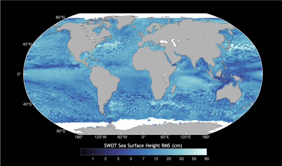
NASA's PO.DAAC released several Surface Water and Ocean Topography (SWOT) ancillary data products. The SWOT mission is a joint endeavor of NASA and CNES (Centre National D'Etudes Spatiales) that aims to provide the most accurate data and information about the global ocean and terrestrial surface water (lakes, rivers, and wetlands). Datasets included in this release are:
- Medium-accuracy Orbit Ephemeris (MOE, SWOT_MOE_1.0): Provides the position and velocity vectors of the satellite center of mass used in forward stream processing; available with latency of < 1.5 days
- Precise Orbit Ephemeris (POE, SWOT_POE_2.0): Provides the position and velocity vectors of the satellite center of mass used in the first SWOT reprocessing; available with latency of < 35 days
- Satellite Attitude Reconstructed (SWOT_ATTD_RECONST_2.0): Uses onboard gyro and star tracker data; available with latency of < 1.5 days
- Satellite Center of Mass Position (SWOT_SAT_COM_1.0): Provides center of mass with respect to the satellite's reference point; available with latency of < 1.5 days (Note: This is a historical product and the most recently available file provides a complete history since launch)
- Tracking Data from Onboard Doppler Orbitography and Radiopositioning Integrated by Satellite (DORIS) and Global Positioning System Payload instruments (SWOT_L1_DORIS_RINEX_1.0 and SWOT_L1_GPSP_RINEX_1.0): Each instrument product available with a latency of < 2 days
Users are encouraged to read the SWOT User Handbook for guidance about data usage and the Product Description Documents (PDDs) for detailed explanations of data product content and format.
Access SWOT ancillary data products and more information
