Forecasting and Understanding Mountain Gap Winds: A Machine Learning Approach

Dr. Emily Foshee advances our ability to understand and predict mountain gap winds that result from the interaction between the larger scale atmospheric flow and terrain.

IMPACT member Dr. Emily Foshee has just concluded research focused on increasing our understanding and prediction of terrain-driven low-level wind jets (known as mountain gap winds or MGW) that result from the interaction between the larger scale atmospheric flow and terrain. While this phenomenon occurs in many locations across the globe, Dr. Foshee focused specifically in the region of the Gulf of Tehuantepec in the eastern Pacific. The resulting MGW here originates from the Chivela Pass in the Sierra Madre mountain range and extends hundreds of kilometers over the gulf. Additionally, it’s one of the few phenomena characterized by such wide-spread and sustained hurricane-force winds.

Asked about the applications of this line of research, Dr. Foshee explained, “Increasing the predictive capability of MGW is important as onset of this phenomena as it flows out and over the ocean can induce strong cold water upwelling and a pretty substantial reduction in sea-surface temperatures of as much as 8 C. This upwelling of colder, more nutrient rich water can affect the distribution of marine life and subsequently fishing; a vital industry within the region.”

Two main aspects addressed by Dr. Foshee’s research are: 1) How to improve the skill of forecasting of MGW over the Gulf of Tehuantepec, and 2) What are the impacts of MGW on tropical cyclone evolution and intensification? The first aspect took two approaches. The first aspect of the research involved utilizing traditional forecast models to understand the governing processes that drive the evolution of the gap winds and determining how to best represent these processes within the model. In the second aspect, Dr. Foshee utilized a non-traditional approach utilizing machine learning techniques to create short-term point predictions of wind speed within the climatological maximum in wind speed in the jet. The second aspect examined the effects of MGW on the evolution and intensification of tropical cyclones (TC) in the eastern Pacific.

The results of this research into the utilization forecast models demonstrate that a very specific Numerical Weather Prediction (NWP) configuration was required to accurately predict the strength of the jet. This configuration required small horizontal grid spacing, appropriate scale interactions, and the inclusion of ocean-atmosphere coupling that best resolved processes such as heat fluxes, vertical mixing, and baroclinicity within the boundary layer. While making these changes within operational forecast models is not feasible, the results did show high-resolution representations of the connections between the structure of the jet and physical processes not previously seen before; helping to further our understanding of gap winds over the Gulf of Tehuantepec.
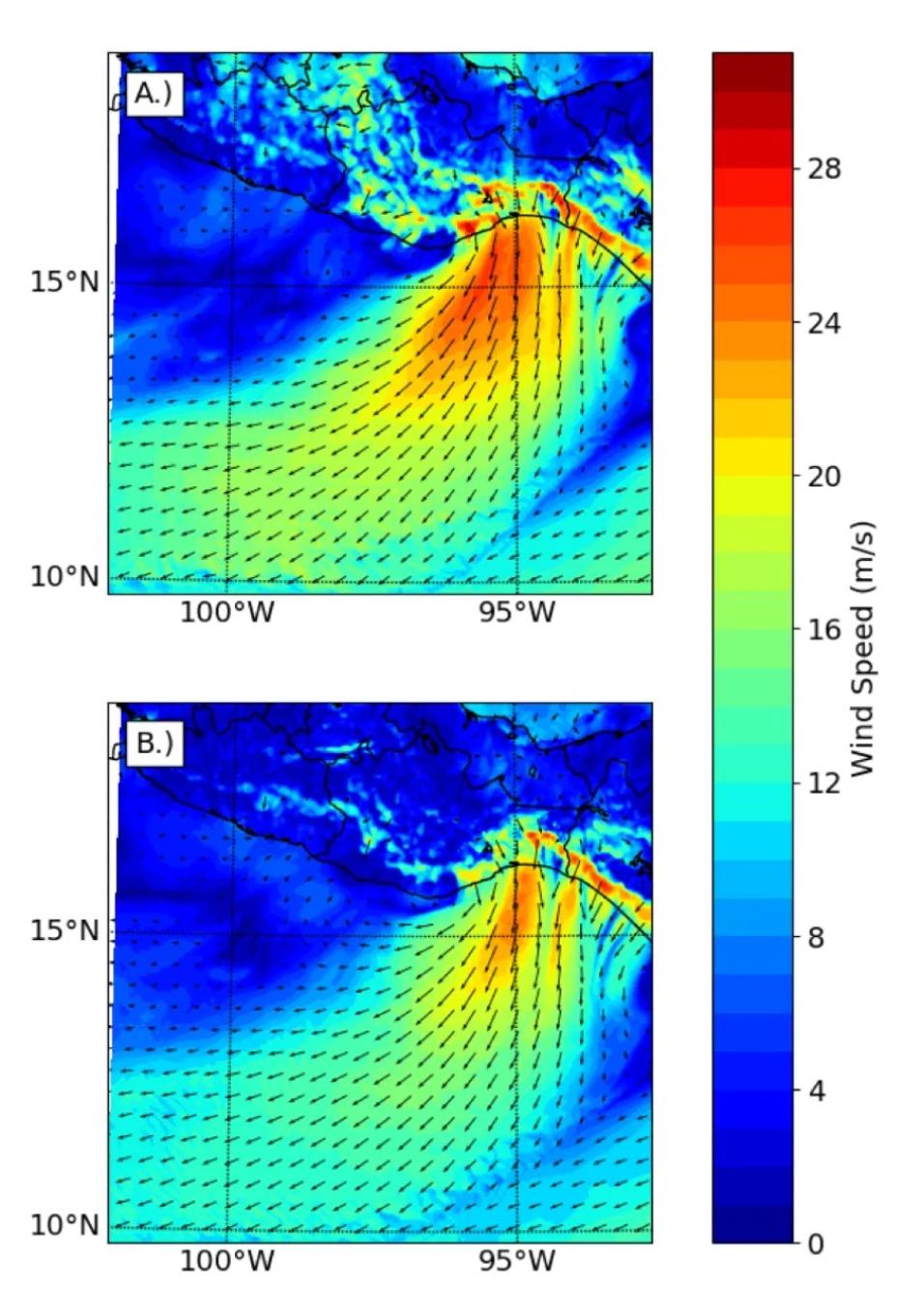
Two Model simulations of a storm-force Mountain Gap Wind event over the Gulf of Tehuantepec.
Image Caption

Model simulations of a storm-force MGW event over the Gulf of Tehuantepec. Top plot represents the spatial distribution of 10-meter winds (in meters per second) if ocean-atmosphere effects are not included in the forecast model, and bottom plot shows simulation results if ocean-atmosphere effects are included in the forecast model. Ocean-atmosphere effects produce more realistic wind speeds by altering boundary layer processes important for MGW prediction.

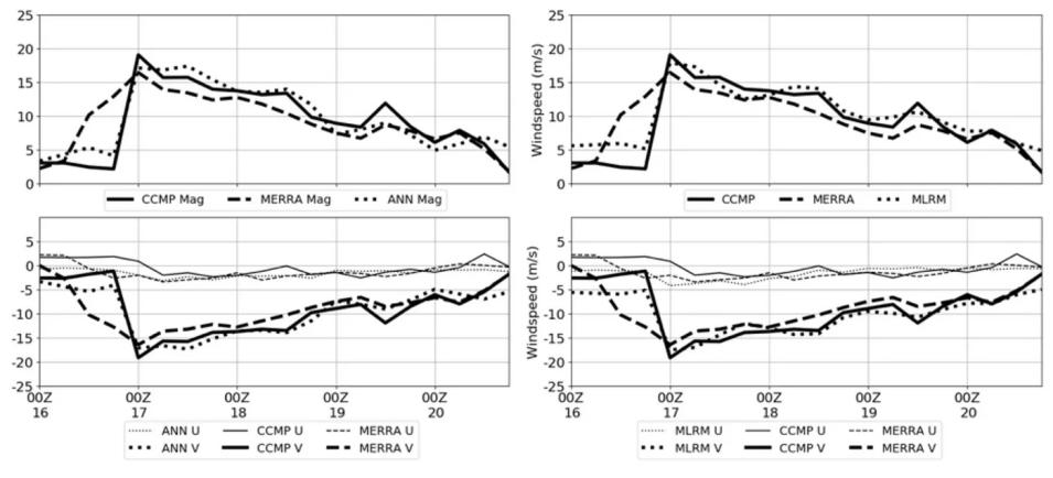
This research also illustrated that in cases where this NWP implementation is not feasible, machine learning (specifically Multiple Linear Regression and Recurrent Neural Networks) can be used to improve upon existing models. While in this case, the MLRM outperformed the RNN, both techniques had errors comparable to previous literature comparing model output to ground observations. Additionally, both techniques were able to capture the abrupt onset as well as the diurnal cycle of the jet. Interestingly, the best predictors for the machine learning models were found to be representations of the same dominant processes noted within the NWP study. Similar NWP results required a very specific configuration, as well as extensive computation time and power. Short term predictions utilizing machine learning and historical data was near-instantaneous for years’ worth of predictions on a single processor. Also, the RNN is able to detect relevant patterns using smaller training datasets and is likely more suited for more non-linear phenomena for future work.

Two graphs showing the results of short-term Mountain Gap Winds point predictions of wind speed (in meters per second) from the multiple linear regression model and the recurrent neural network.
Image Caption

Results of short-term (24 hour) MGW point predictions of wind speed (in meters per second) from the multiple linear regression model (left, dotted line) and the recurrent neural network (right, dotted line). Top plot shows the overall magnitude of the horizontal wind and bottom plot shows the individual u and v components of the horizontal wind. Also plotted are the corresponding “truth” data using satellite-derived wind fields (CCMP, solid line) and NASA MERRA (dashed line) reanalysis data used as predictors for the models. 24-hour times series of MERRA data for the previous day was used to predict CCMP 24-hour time series for the next day.

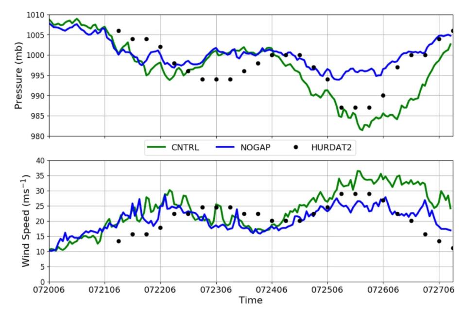
Finally, again utilizing NWP, this research examined effects of removing the influence of gap winds in the eastern Pacific. For the 2008 Hurricane Genevieve, results show a storm with a lower central pressure, higher winds, and a slight difference in track compared to a case without the MGW influence. Associated wind shear lead to the production of cyclonic vorticity that added to the ambient vorticity field of Genevieve. High winds led to increased heat and moisture fluxes into the storm, and frictional convergence associated with the ingestion of higher momentum air aided in providing moisture lift which affected precipitation patterns across the eastern Pacific. However, further investigation into more cases is needed to fully understand how the conceptual model of TC/MGW interaction differs upon varying intensity of TC and MGW.

Two graphs showing the effects of removing the Mountain Gap Winds influence over the Gulf of Tehuantepec on the Category One Hurricane Genevieve
Image Caption

Effects of removing the MGW influence over the Gulf of Tehuantepec on the Category One Hurricane Genevieve in 2008. Green line represents the model simulation where terrain was left unmodified and the jet from the Chivela Pass was allowed to affect the tropical cyclone (CNTRL), blue line represents the results from where terrain was modified to remove the influence of the jet (NOGAP), and black dots represent the corresponding observations recorded from the National Hurricane Center. Top plot shows central pressure in millibars and bottom shows maximum wind speed near the eye wall in meters per second.

Details

Last Updated

Published