NASA FIRMS Helps Fight Wildland Fires in Near Real-Time

NASA’s worldwide Fire Information for Resource Management System (FIRMS) provides vital near real-time tools for managing wildland fires.

Fahrenheit 572 is a critical value for wildland firefighters. This is the temperature at which wood releases hydrocarbon gases that mix with oxygen, combust, and ignite. With a source of fuel and air, along with enough heat to bring this volatile mixture to its ignition temperature, a wildland fire can become an uncontrolled, self-sustaining cataclysm.

Locating these fires rapidly is vital to managing and containing these natural and, in many cases, human-caused events. A key resource for wildland firefighters and managers around the world is NASA’s Fire Information for Resource Management System (FIRMS), which is part of NASA’s Earth Observing System Data and Information System (EOSDIS).

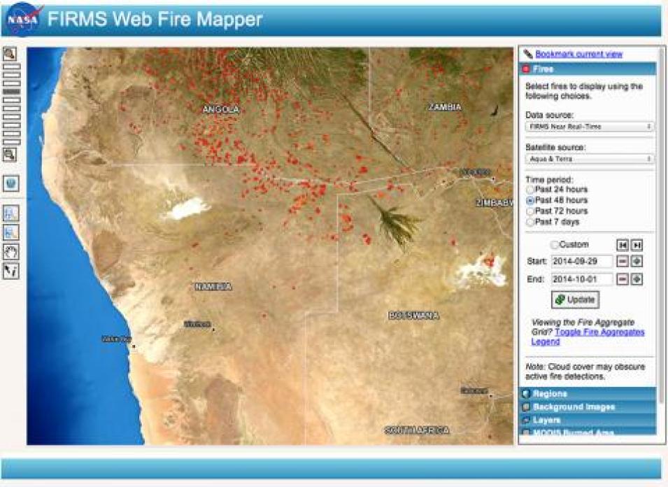
FIRMS Web Fire Mapper showing fires/hotspots in Angola, Namibia and Botswana
Image Caption

Each red or orange dot on the FIRMS Web Fire Mapper image is a hot spot detected by the MODIS instrument. Image courtesy of NASA LANCE.

Through FIRMS, users can interactively view fire data via the Web Fire Mapper; search the entire archive of active fire / hot spot data derived from the Moderate Resolution Imaging Spectroradiometer (MODIS) instrument aboard NASA’s Aqua and Terra satellites; and sign up to receive automated Fire Email Alerts for their geographic areas of interest. More importantly for wildland managers, FIRMS data are available within three hours of a satellite overflight, making these near real-time (NRT) data valuable tools for helping first responders pinpoint the approximate location of a potential wildland fire and track the development of established fires – especially in remote or rugged areas.

Diane Davies is the Operations Manager for NASA’s Land, Atmosphere Near real-time Capability for EOS (LANCE) system, which provides more than 40 NRT data products from instruments aboard NASA’s suite of Earth observing satellites. Davies was part of the team that developed the Web Fire Mapper as an interactive system where users could see where fires were occurring. Davies and her team soon discovered that there was a huge demand for fire data and a need to deliver this information rapidly.

“We realized that there were a lot of users with very poor Internet access or in very remote areas,” Davies says. “So they said, ‘well can you just send me a notification of when there is a fire occurring in my area of interest?’ So we developed the e-mail alert system.”

Davies notes that every day more than 2,000 FIRMS e-mail alerts are sent to users in over 120 countries.

FIRMS was developed by the University of Maryland in 2007 with funds from NASA’s Applied Sciences Program and the United Nations Food and Agriculture Organization (UN FAO). NASA began offering FIRMS data in 2007, and the UN FAO began offering FIRMS data in 2010 through its Global Fire Information Management System (GFIMS).

The data used to generate FIRMS products comes from the MODIS Thermal Anomalies and Fire Product on the Aqua and Terra satellites. Aqua and Terra are two of NASA’s more than 20 orbiting Earth Observing System (EOS) satellites, which provide a steady stream of data about Earth processes as they circle the planet. Both satellites pass over the equator twice each day, providing at least four daily MODIS observations for almost every area on the equator. MODIS provides global coverage every 1-2 days.

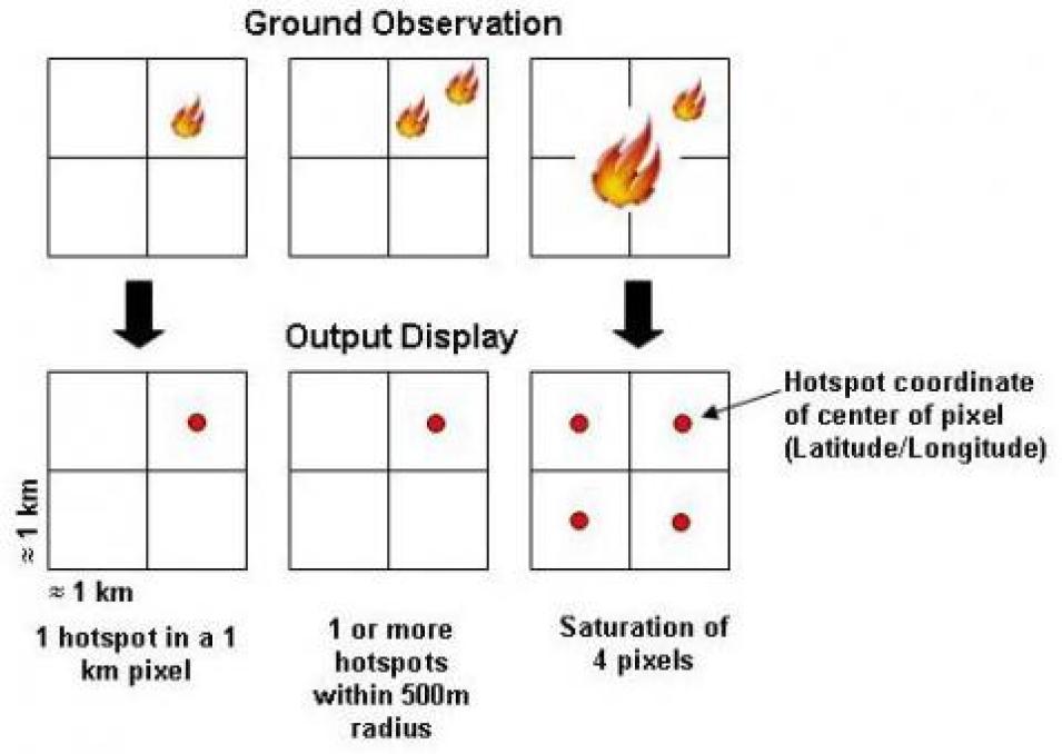
MODIS fire/hotspots represent the center of an approximately 1km pixel
Image Caption

A MODIS indicated hot spot represents the center of an approximately 1 km2 pixel flagged as containing one or more thermal anomalies. The hot spot “location” is the center point of the pixel, which is not necessarily the coordinates of the actual fire. Image courtesy of NASA LANCE.

The sensitivity of the sensors and instruments aboard these satellites allows scientists and researchers to study our planet in minute detail, and, in the case of wildland fires, identify areas that may need a closer look. Using a complex algorithm, hot spots detected by the MODIS instrument are designated as the center of an approximately 1 km2 pixel that may contain one or more fires or other thermal anomalies (such as an erupting volcano). This makes it much easier for fire crews and wildland managers to locate a potential wildland fire. Through NASA’s LANCE system, MODIS data products are available within three hours of a sensor overpass (the average latency of MODIS data is 60-125 minutes).

“We are an additional source for fire information,” Davies says. “Quite often, it might be the first time people have heard about a fire in their area, or they’ve heard about a fire and they didn’t know where it was. So having the approximate coordinates [of the fire] gives them a good idea of where they should be looking.”

Along with MODIS, NRT products are available for the Ozone Monitoring Instrument (OMI), Microwave Limb Sounder (MLS), and Atmospheric Infrared Sounder (AIRS) instruments on NASA’s Aqua, Aura, and Terra satellites. The wealth of NRT data available through LANCE can be viewed as browse imagery using NASA's Worldview, and NRT data can be downloaded after registering at the EOSDIS User Registration System (URS) website. As part of NASA’s Open Data Policy, LANCE data are available to users around the world.

It is important to realize that the trade-off for having NRT data is that the data have minimal processing, and geolocation is based on predictive rather than definitive satellite orbit information. This, in turn, could lead to small differences (generally less than 100 meters [328 feet]) between a data-depicted hot spot and the actual location of the hot spot on the ground. Still, the benefits of having near real-time data, especially for wildland managers, means that decisions also can be made in near real-time.

“Using the MODIS imagery, you can pick out the area that is already burned, which helps because if you know what’s burned and you know where the hot spots are and you have an idea of the wind direction, this helps with your strategic fire planning,” Davies says. “It also helps because they can see the smoke and the thickness of the smoke, which is helpful if they’re trying to fly in or do aerial fire management.”

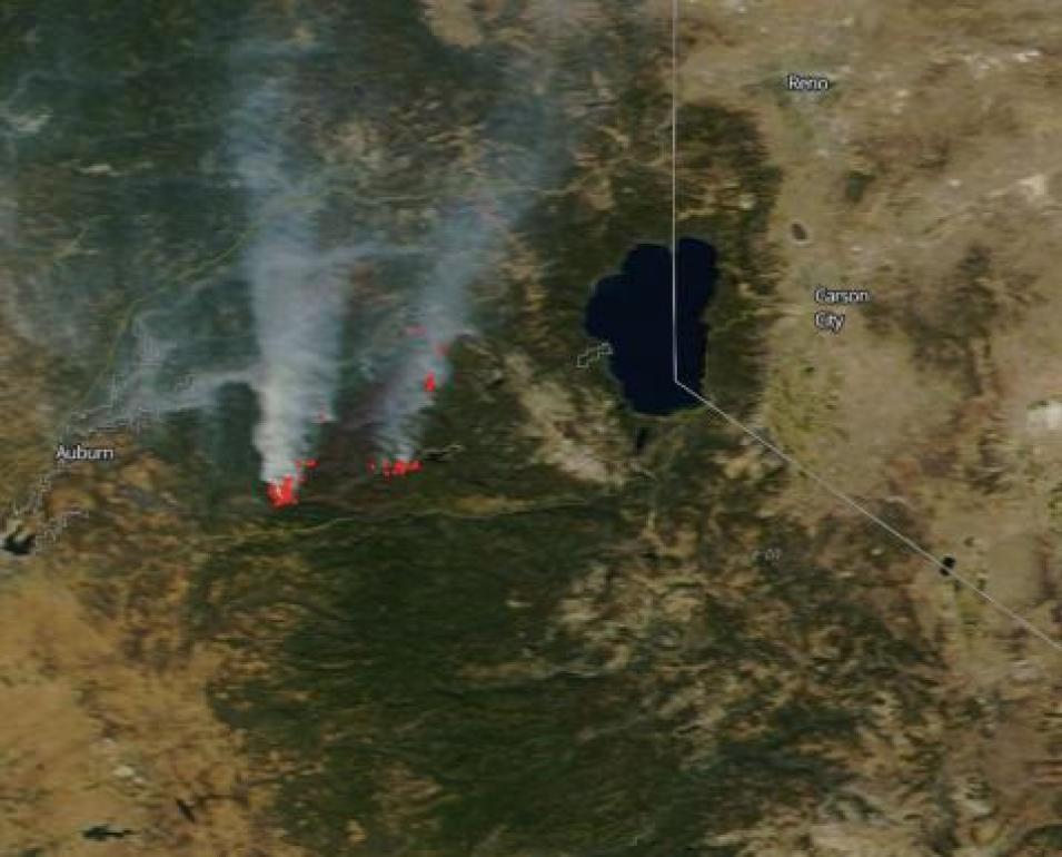
A MODIS image of California's King Fire from September 24, 2014
Image Caption

A MODIS image of California's King Fire from September 24, 2014, visualized using the Worldview tool. Red dots are hot spots detected by MODIS. White areas are smoke. Lake Tahoe is to the right. Image courtesy of NASA Worldview.

Today, MODIS and FIRMS are being used to help manage wildland fires around the world. Along with their use by the UN FAO, the U.S. Forest Service (USFS) uses MODIS fire detection data and maintains public archives of fire data dating back to 2001 through their Remote Sensing Applications Center. LANCE MODIS fire data also are a cornerstone of the Firecast system developed by Conservation International for detecting fires in Peru, Bolivia, Madagascar, and Indonesia. CI uses additional LANCE products as forecasting tools to help predict areas that may be susceptible to wildland fires.

“We have lots of users who broker the FIRMS data – they take the data and add value to it,” Davies says. “For example, in India the Forest Departments in both the Uttar Pradesh and Madhya Pradesh take the data and create their own fire alerts, which they send to mobile phones and distribute via e-mail. In Thailand, the Department of National Parks sends e-mail alerts in Thai to managers at all forest parks. The Vietnam National University recently set up their own version of FIRMS, and the European Union’s Joint Research Centre has created a Web client for fire monitoring in protected areas of Africa using data from FIRMS.”

The first step for using FIRMS data is to visit the FIRMS webpage. From here, you can:

  • Download recent and historic global MODIS fire locations in a variety of file formats
  • Sign up to receive FIRMS Fire Email Alerts
  • Interactively browse daily global MODIS fire locations and monthly burned areas through Web Fire Mapper
  • View and download global 10-day fire maps and monthly composite animations by year

While wildland fires will continue to be an integral component of wildland development and evolution, the near real-time MODIS data provided through LANCE coupled with FIRMS products makes it easier to manage these global events and give those living in fire-prone areas around the world more control over the chaos these events can bring. For Davies, this is the proof that FIRMS is a valuable addition to the global wildland fire management toolbox.

“We couldn’t do what we’ve done if we didn’t have such good data. The demand for the data was there – people need fire information and they need it in real time,” she says.

References

Conservation International. 2014. “Firecast: About.” Conservation International website, http://firecast.conservation.org.

Davies, D., et al. 2009. “Fire Information for Resource Management System: Archiving and distributing MODIS Active Fire Data.” In IEEE Transactions on Geoscience and Remote Sensing 47(1): 72-79. doi: 10.1109/TGRS.2008.2002076.

Gabbert, B. 2011. “At what temperature does a forest fire burn?” Wildfire Today website, http://wildfiretoday.com/2011/02/26/at-what-temperature-does-a-forest-fire-burn.

NASA. Near Real-Time Imagery and Data. Brochure. Washington: National Aeronautics and Space Administration.

Tabor, K. 2014. “Conservation Tools: Satellites Sound Fire Alarm in Tropical Forests.” Conservation International blog, 08/26/2014. http://blog.conservation.org/2014/07/conservation-tools-satellites-sound-fire-alarm-in-tropical-forests.

Vizcarra, N. 2012. “Orbiting watchtowers.” In Sensing Our Planet, pp. 48-51. Washington: National Aeronautics and Space Administration.

Helpful Websites

EOSDIS User Registration Service (URS): https://urs.earthdata.nasa.gov/users/new

FIRMS Near Real-Time Webpage: /firms

LANCE Near Real-Time Webpages: /lance

NASA Common Metadata Repository: /eosdis/science-system-description/eosdis-components/cmr

NASA Worldview: https://worldview.earthdata.nasa.gov

We acknowledge the use of FIRMS data and imagery from the Land, Atmosphere Near real-time Capability for EOS (LANCE) system operated by the NASA/GSFC/Earth Science Data and Information System (ESDIS).
Details

Last Updated

Published