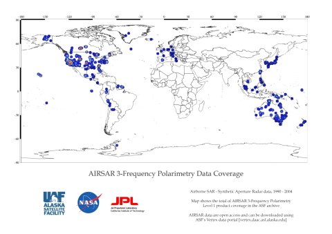
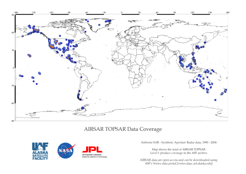
Description
Airborne SAR (AIRSAR) was a prototype JPL earth-observation project equipped with synthetic aperture radar (SAR) — an all-weather imaging tool able to penetrate clouds and collect data at night. Two of the AIRSAR imaging modes used could penetrate into the forest canopy, dry snow cover, and, in extremely dry areas, sand.
AIRSAR was a NASA radar technology testbed to demonstrate new radar technology and acquire data for developing radar processing techniques and applications.
| Dataset Property | P-Band | L-Band | C-Band |
|---|---|---|---|
| Temporal Coverage | 1988-2004 | 1988-2004 | 1988-2004 |
| Spatial Coverage | Worldwide mission-specific sites | Worldwide mission-specific sites | Worldwide mission-specific sites |
| Frequency/Wavelength | 0.45 GHz/67 cm | 1.26 GHz/23 cm | 5.31 GHz/5.7 cm |
| Polarization | Full | Full | Full |
| Range Resolution | 7.5 m | 3.75 m | 1.875 m |
| Swath Width | 10 km | 10 km | 10 km |
| Off-Nadir Angle | 20-60° | 20-60° | 20-60° |
| File Format | AIRSAR (proprietary), JPG | AIRSAR (proprietary), JPG | AIRSAR (proprietary), JPG |
| Date Published | 1988-2004 | 1988-2004 | 1988-2004 |
Read more on the JPL AIRSAR website.
AIRSAR Products
- Airborne SAR — synthetic aperture radar
- 1990-2004
- Primarily covers the United States; other tropical locations included
- Datasets identified by place name
Downloadable Data:
- PolSAR: 3-frequency polarimetry
- TOPSAR: C-, L-, and P-band Compressed Stokes Matrix, C-band TIFF, DEM
- ATI — Along-track interferometry: Interferograms
More detailed product descriptions are available from the AIRSAR website
Find AIRSAR data. No proposals required.
AIRSAR TOPSAR data formats and files
| Format | Product Name | Product Files | Open-source Tools | Can Be Used For |
|---|---|---|---|---|
| AIRSAR | C-band DEM and Compressed Stokes Matrix | c.corgr, c.demi2, c.vvi2 | MapReady, PolSARpro | Polarimetry |
| AIRSAR | L-band Compressed Stokes Matrix | l.datgr | MapReady, PolSARpro | Polarimetry |
| AIRSAR | P-band Compressed Stokes Matrix | p.datgr | PolSARpro | Polarimetry |
AIRSAR PolSAR – AIRSAR ATI (Experimental) data formats and files
| Format | Product Name | Product Files | Processing Level | Open-source Tools | Can Be Used For |
|---|---|---|---|---|---|
| AIRSAR | 3-Frequency Polarimetry | c.dat, l.dat, p.dat | Compressed stokes matrix | MapReady, PolSARpro | Polarimetry |
| JPG | Along-Track Interferometry | *intf*, *uwScc*, *az*, *uwWrp*, *uwWcc*, *uwWrp, *par, *ppp | SLC, MLC | N/A | Ocean current velocity measurement |
Product Summary

Citation
Citation is critically important for dataset documentation and discovery. This dataset is openly shared, without restriction, in accordance with the EOSDIS Data Use Policy.
Copy Citation
Data Center Citation
How to Credit AIRSAR Data and Imagery
| Dataset Product | How to Credit | Format | Example |
|---|---|---|---|
| AIRSAR Data | Credit use of data in publications such as journal papers, articles, presentations, posters, and websites. Please send copies of, or links to, published works citing data, imagery, or tools accessed through ASF to uso@asf.alaska.edu with “New Publication” on subject line. | Dataset: AIRSAR, NASA [year of data acquisition]. Retrieved from ASF DAAC [day month year of data access]. | Dataset: AIRSAR, NASA 2003. Retrieved from ASF DAAC 7 June 2015. |
| AIRSAR Imagery | Include credit with each image shown in publications such as journal papers, articles, presentations, posters, and websites. | NASA [year of data acquisition] | NASA 2003 |
