Planet Labs PBC (Planet) distributes optical to near-infrared data acquired by the following Planet small satellite (SmallSat) constellations: PlanetScope, RapidEye, and SkySat.

The PlanetScope constellation of Dove SmallSats can image Earth’s entire land surface every day with a resolution of 3 m/pixel. Dove constellation instruments have ongoing new generations that have additional band and larger square kilometers per individual image captured.

RapidEye is a retired constellation of five SmallSats operational from 2009 to 2020. The constellation captured more than 660,000 images of Earth’s total landmass. RapidEye image resolution is approximately 5 m/pixel.

SkySat platforms can revisit any location on Earth up to 10 times a day, obtaining 50 cm/pixel high-resolution imagery. CSDA has acquired a limited set of SkySat data.

Planet was one of the companies selected for evaluation in the original NASA Commercial SmallSat Data Acquisition (CSDA) program Pilot.

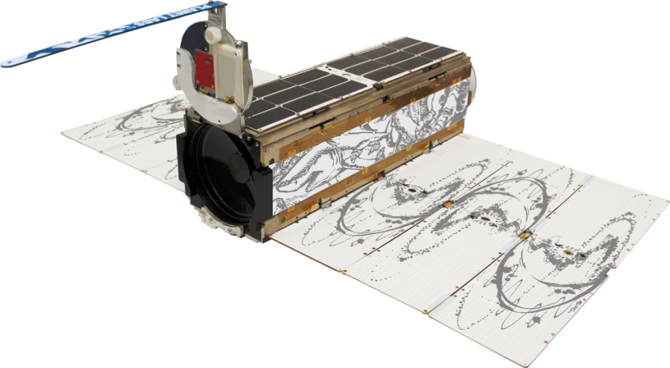
Photo of Planet's Planetscope satellite.
Image Caption

A PlanetScope satellite. Credit: Image courtesy of Planet.

Authorized Data Use and Users

NASA-purchased Planet data are available to U.S. Federal civil agencies (including the National Science Foundation) and their contractors, subcontractors, partners, and grantees supporting entities for scientific use.

Approved scientists can use Planet data for research, experiments, evaluation, and development—including basic and applied research—that may lead to journal publications, licensed user-derived data products, white papers and maps for use by the broader scientific community, or to support logistical planning of future scientific research experiments such as field campaigns.

Planet data may not be used operationally for non-scientific logistical planning, response efforts outside U.S. Government agency applied science missions, management of human resources, remote monitoring (i.e., construction, facility monitoring, etc.), enforcing compliance of regulations, and law enforcement and investigations.

End User License Agreement

Planet Expanded EULA

Obtaining Data

Requesting PlanetScope and RapidEye data:

  • Contact CSDA and provide a name, email address, and other pertinent information (grant number, contract number, etc.) for data access approval
  • CSDA will verify the request, notify Planet, and initiate the creation of a user account
  • Once an account is approved and created, the user will receive notification and may then search and browse imagery using the Planet Explorer data discovery tool and place a data request order
  • A data download URL will be sent to the user via email or the user can download the data directly from the Planet API

Each PlanetScope and RapidEye user will be allocated a 5 million km2 quota. PlanetScope data will only be available 30 days after acquisition by the satellite constellation. However, exceptions to both conditions can be made based on additional justifications.

Accessing SkySat data:

  • Contact CSDA and provide a name, email address, and other pertinent information (grant number, contract number, etc.) for data access approval
  • Search the CSDA SmallSat Data Explorer (SDX; note: An Earthdata Login is required for access)
  • Review discovered data and download direct from the SDX or using the Bulk Download Tool

Approved users have access to all PlanetScope and RapidEye data, and a limited set of SkySat data.

Note that Planet basemap products are not available through the CSDA program.

Copyright

Data products and derivatives must contain the following copyright markings (where YYYY is the year of the image acquisition):

  • For data products: “© Planet Labs PBC YYYY. All rights reserved.”
  • For derivatives: “Includes copyrighted material of Planet Labs PBC. All rights reserved.”
  • A joint copyright notice may be used as appropriate

Authorized users should send Planet a courtesy copy of any publications that include Planet data.

CSDA Acknowledgment

To help CSDA identify your publications, we request that you include the following acknowledgment when publishing work created using these data:

"This work utilized data made available through the NASA Commercial SmallSat Data Acquisition (CSDA) Program."

Evaluation

In addition to the initial evaluation completed during the CSDA Program's Pilot, a geometric evaluation was done and a report and presentation are available.

Planet Commercial Data

PlanetScope/Dove Satellite Constellation and Instrument Characteristics
Mission CharacteristicsInternational Space Station Orbit
Orbit Altitude (reference)400 km (51.6° inclination)
Max/Min Latitude Coverage+/- 52° (depending on season)
Equator Crossing TimeVariable
Sensor TypeThree-band frame Imager or four-band frame Imager with a split-frame NIR filter
Spectral BandsBlue: 455-515 nm Green: 500-590 nm Red: 590-670 nm NIR: 780-860 nm
Ground Sample Distance (nadir)3.0 m (approximate)
Frame Size20 km x 12 km (approximate)
Maximum Image Strip per Orbit8,100 km2
Revisit TimeVariable
Image Capture CapacityVariable
Camera Dynamic Range12-bit
PlanetScope/Dove in Sun-Synchronus Orbit
Mission CharacteristicsDove Classic (PS2)Dove-R (PS2.SD)SuperDove (PSB.SD)
Orbit Altitude (reference)450–580 km
Inclination~98°
Max/Min Latitude Coverage±81.5° (depending on season)
Equator Crossing Time9:30 to 11:30 a.m. (local solar time)
Sensor TypeThree-band frame Imager or four-band frame Imager with a split-frame NIR filterFour-band frame imager with butcher-block filterEight-band frame imager with butcher-block filter
Spectral BandsBlue: 455–515 nm Green: 500–590 nm Red: 590–670 nm NIR: 780–860 nmBlue: 464–517 nm Green: 547–585 nm Red: 650–682 nm NIR: 846–888 nmCoastal Blue: 431–452 nm Blue: 465–515 nm Green I: 513–549 nm Green II: 547–583 nm Yellow: 600–620 nm Red: 650–680 nm Red-Edge: 697–713 nm NIR: 845–885 nm
Ground Sample Distance (nadir)3.7 m (approximate)
Frame Size24 km x 8 km (approximate)24 km x 16 km (approximate)32.5 km x 19.6 km (approximate)
Maximum Image Strip per Orbit20,000 km2
Revisit TimeNear-daily at nadir
Image Capture Capacity~350 million km2/day
Camera Dynamic Range12-bit
RapidEye Satellite Constellation and Instrument Characteristics
Mission CharacteristicsInformation
Number of Satellites1
Orbit Altitude630 km in Sun-Synchronous Orbit
Equator Crossing Time11:00 a.m., local solar time (approximate)
Sensor TypeMultispectral push broom
Spectral BandsBlue: 440–510 nm Green: 520–590 nm Red: 630–685 nm Red Edge: 690–730 nm NIR: 760–850 nm
Ground Sampling Distance (nadir)6.5 m
Swath Width77 km
Maximum Image Strip per OrbitUp to 1,500 km of image data per orbit
Revisit TimeDaily (off-nadir)/5.5 days (at nadir)
Image Capture Capacity> 6 million km2/day
Camera Dynamic Range12-bit
SkySat Satellite Constellation and Instrument Characteristics
AttributeValue
Mass110 kg
Dimensions60 x 60 x 95 cm
Total DeltaV180 m/s
Onboard Storage360 GB + 360 GB cold spare storage
RF CommunicationX-band downlink (payload): variable, up to 580 Mbit/s X-band downlink (telemetry): 64 Kbit/s S-band uplink (command): 32 Kbit/s
Design Life~6 years
Geolocation Knowledge30 m CE90 in a 500 km altitude orbit
Ground Sample Distance[SkySat-1, SkySat-2] Panchromatic: 0.86 m Multispectral: 10 m [SkySat-3 – SkySat-13] Panchromatic: 0.72 m Multispectral: 1.0 m 2.3 targets (6.6 x 10 km) per minute
Revisit (per satellite)4-5 days *Reference altitude 500 km
Equatorial Crossing Time (UTC)10:30: Current C-Gen satellites 13:00: SkySat-1 and SkySat-2 13:00: Block-2 C-Gen satellites
Image ConfigurationsMultispectral Sensor (Blue, Green, Red, NIR) Panchromatic Sensor
Product FramingSkySat Satellites have three cameras per satellite that capture overlapping strips. Each of these strips contains overlapping scenes. One scene is approximately 2560 x 1080 pixels
Sensor TypeCMOS Frame Camera with Panchromatic and Multispectral halves
Spectral BandsBlue: 450–515 nm Green: 515–595 nm Red: 605–695 nm NIR: 740–900 nm Pan: 450–900 nm