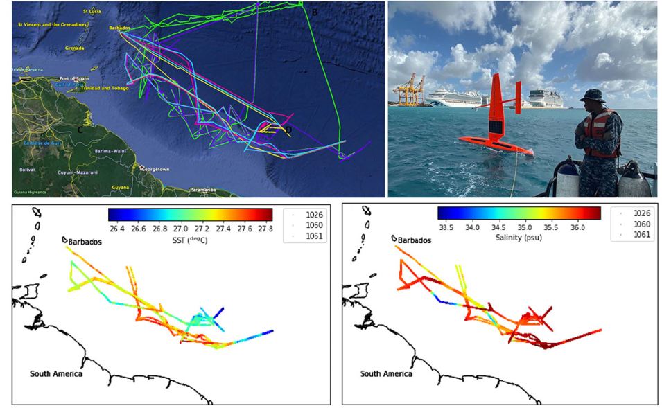
Saildrone is a remotely-controlled platform that can be configured with a variety of instruments to collect data over long distances and relay live data wirelessly to research teams. Between January 17 and March 2, 2020, a fleet of Saildrone unmanned surface vehicles (USVs) plied the Atlantic Ocean waters off the island of Barbados in a joint NASA/NOAA-funded research project. The data collected by these USVs are now available at NASA’s Physical Oceanography Distributed Active Archive Center (PO.DAAC) as part of the Atlantic Tradewind Ocean-Atmosphere Mesoscale Interaction Campaign (ATOMIC).
New Saildrone Dataset at NASA’s PO.DAAC
(Upper Left) Survey tracks of the five Saildrone USVs deployed during the ATOMIC field campaign. (Upper Right) Saildrone leaving Barbados. (Lower Left) Along track surface temperature maps for the three NASA Saildrone USVs. (Lower Right) Along track surface salinity maps for the three NASA Saildrone USVs. Click on image for larger view. Image and text courtesy of NASA’s PO.DAAC.
The Saildrone ATOMIC dataset (doi:10.5067/SDRON-ATOM0) comprises two data files for each of the three NASA-funded Saildrone USVs that were deployed (two additional Saildrones in the deployment were NOAA-funded). One data file contains near-surface observational data (air temperature, sea surface skin and bulk temperatures, salinity, oxygen and chlorophyll-a concentrations, barometric pressure, and wind speed and direction). The second data file has Acoustic Doppler Current Profiler (ADCP) data spanning the entire cruise for each Saildrone.
The objective of ATOMIC was to acquire data to better understand ocean-atmosphere interactions, particularly over mesoscale ocean eddies. As noted by NOAA’s Geophysical Fluid Dynamics Laboratory, mesoscale ocean eddies are common ocean features that are dynamically analogous to atmospheric weather. Their swirling circulation, generally extending about 100 kilometers in diameter or less, is characterized by salinity and temperature differences that enable them to transport properties such as heat, salt, and carbon around the ocean.
Saildrone-acquired data are being used to support NASA satellite calibration/validation and ocean science studies, including the improvement of salinity and sea surface temperature (SST) retrievals at high latitudes and along coasts. Data from four Saildrone field campaigns are available through PO.DAAC, which is responsible for archiving and distributing physical oceanography data in NASA’s Earth Observing System Data and Information System (EOSDIS) collection.
The Saildrone Field Campaign Surface and ADCP Measurements for the ATOMIC Project dataset is accessible via the PO.DAAC data portal. Additional information is available on PO.DAAC’s Saildrone Mission page.
