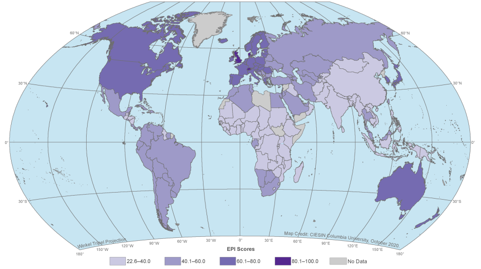
The 2020 release of the Environmental Performance Index (EPI) is now available at NASA’s Socioeconomic Data and Applications Center (SEDAC). Produced every two years since 2006, the 2020 EPI (doi:10.7927/f54c-0r44) ranks 180 countries in environmental health and ecosystem vitality based on 32 performance indicators in 11 issue categories: air quality, sanitation and drinking water, heavy metals, waste management, biodiversity and habitat, ecosystem services, fisheries, climate change, pollution emissions, agriculture, and water resources. The 2020 release includes a report, data sets for download, and a gallery of nearly 100 maps visualizing changes in performance over more than two decades.
New Environmental Performance Index (EPI) Available at NASA’s SEDAC
Summary EPI 2020 global map available through NASA's SEDAC showing aggregate 2020 EPI scores, with darker colors indicating higher EPI scores. Click on image for larger view. Image: YCELP, Yale University, and CIESIN, Columbia University. 2020. 2020 Environmental Performance Index (EPI). Palisades, NY: NASA SEDAC. doi:10.7927/f54c-0r44. Accessed 25 November 2020.
The EPI provides quantitative metrics for evaluating a country’s environmental performance in different policy categories relative to clearly defined targets, and aggregates data on many indicators of sustainability into a single number – the EPI Score, which ranges from 0 to 100. Its proximity-to-target methodology facilitates cross-country comparisons among economic and regional peer groups.
Nations with the top five EPI scores in 2020 are Denmark (82.5), Luxembourg (82.3), Switzerland (81.5), the United Kingdom (81.3), and France (80.0). The United States received an EPI score of 69.3 (mainly due to low scores on Water Resources and Waste Management), ranking it in 24th place behind Malta. The five lowest-scoring nations in 2020 are Côte d’Ivoire (25.8), Sierra Leone (25.7), Afghanistan (25.5), Myanmar (25.1), and Liberia (22.6). For detailed information about the EPI methodology and a full summary of results, please see the 2020 EPI Report.
Developed by the Yale Center for Environmental Law and Policy (YCELP) and Columbia University’s Center for International Earth Science Information Network (CIESIN), the EPI is archived at and distributed by SEDAC. SEDAC is the home for socioeconomic data in NASA’s Earth Observing System Data and Information System (EOSDIS) collection. Hosted at CIESIN, SEDAC synthesizes Earth science and socioeconomic data and information in ways useful to a wide range of decision makers and other applied users, and serves as an “Information Gateway” between the socioeconomic and Earth science data and information domains.
