The state of Arizona is sinking. The removal of groundwater through pumping for agriculture, development, and other uses contributes to the collapse of pore spaces in the subsurface, resulting in a lowering in land elevation. This subsidence causes millions of dollars in damage to Arizona property and infrastructure and can lead to changes in drainage patterns and weaken water retention features such as dams and levees.
Simplifying SAR
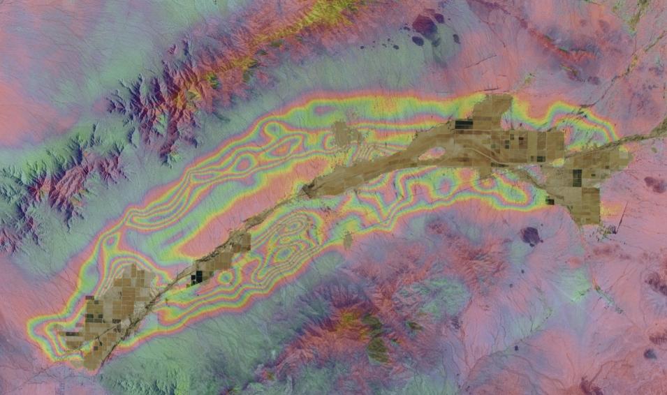
An interferogram of the McMullen Valley groundwater basin in south-central Arizona. Colored fringes indicate changes in elevation between 2010 and 2015. Each complete color sequence fringe in this image, from blue to blue, indicates 2.8 cm (1.1 in) of elevation change. Click on image for larger view. Credit: ADWR.
Monitoring subsidence is one job of the Arizona Department of Water Resources (ADWR), and its monitoring tool of choice is synthetic aperture radar (SAR). SAR uses pulses of radar energy to produce high-resolution images of Earth’s surface, independent of daylight and weather conditions. By comparing images of an identical area captured days, months, or years apart, changes in land surface elevation can be observed and measured to within millimeters. This technique, called interferometry, uses interferometric SAR (InSAR) processing to depict elevation changes as colored fringes on an image called an interferogram.
“Arizona has had well-documented subsidence since the early-1950s,” says Brian Conway, principal hydrologist and supervisor of ADWR’s Geophysics-Surveying Unit. “When SAR technology came around, we applied for a NASA grant in 2002 to start our land subsidence monitoring program. The acceptance and use of [SAR] data in the scientific community has just been phenomenal.”
But SAR does have some drawbacks. The data are very large and take longer to download than other forms of remotely sensed data. This is partly because each pixel of SAR data carries more than one set of information. Along with the image, pixels contain information about the phase (which provides an assessment of distance) and polarization (which provides an understanding of the type of surface the radar signal is hitting).
In addition, processing SAR datasets is computationally intensive and the software tools for working with these datasets are often difficult to use and install. To help mitigate these issues, ADWR SAR and InSAR data were stored on a local server and analyzed using in-house machines. This strategy worked fine; until it didn’t.
The loss of 70 terabytes of SAR data in February 2022 due to a server failure showed the fragility of this system; Conway realized they needed a more efficient way of working with these data. Fortunately, a novel solution was available through OpenSARLab.
OpenSARLab is a service created in 2018 by the Alaska Satellite Facility (ASF) located at the University of Alaska Fairbanks. ASF also is the home of NASA’s ASF Distributed Active Archive Center (ASF DAAC), which archives and distributes NASA’s collection of SAR data. Initially funded through research grants but now hosted and maintained by ASF, OpenSARLab works to enable and accelerate science using SAR data—and to help SAR users like Conway and ADWR.
“OpenSARLab was built to support scientists in taking advantage of this very rich, large dataset and teaching them how to use the dataset,” says Dr. Franz Meyer, ASF chief scientist. “People were clamoring for an environment where they could access large-volume data in place, where they would not have to download gigabytes of data locally, and where they could leverage existing software in an environment that was built exactly for the needs of that software.” In other words, a cloud-based computational environment.
With a fully cloud-based system, Meyer notes that all someone needs to fully exploit and work with SAR data in OpenSARLab is an internet-enabled device that has a web browser—from a laptop to an iPad or even a cell phone. “You can work with thousands of interferograms and analyze years of deformation history easily through a web browser from your couch at home,” he says. “It’s pretty amazing.”
Potential users can request an OpenSARLab account through ASF’s OpenSARLab Access Page. Along with an OpenSARLab account, an Earthdata Login also is required to access data. Numerous data recipes are available through the OpenSARLab GitHub page for working with data, including time series analysis, change detection, and other common SAR data uses. Meyer notes that these recipes are mostly developed for SAR data from the ESA (European Space Agency) Sentinel-1 mission, a currently flying SAR sensor constellation with data available through ASF DAAC.
OpenSARLab runs in the Amazon Web Services (AWS) cloud adjacent to NASA’s Earthdata Cloud, which is the AWS-based architecture for archiving and distributing NASA Earth science data. One long-term ASF goal is to fully transition OpenSARLab into the Earthdata Cloud.
A sister product to OpenSARLab is ASF’s Hybrid Pluggable Processing Pipeline (HyP3, pronounced “hype”) software tool. Hosted in the Earthdata Cloud, HyP3 enables users to quickly and easily turn raw SAR data into analysis ready data (ARD) in the form of interferograms and geocoded image products. “HyP3 allows you to create thousands of interferograms within an hour or two,” says Meyer. “Then OpenSARLab allows you to leverage all of these interferograms directly in place in the cloud, run time series analysis on these products, and then only download your final science result—which is much smaller in volume.”
Another key point Meyer makes is that OpenSARLab is a customizable solution. “For Brian Conway, we customized an OpenSARLab deployment that had exactly the tools he needed,” he says. “We set everything up for him in the cloud and in an environment that he fully controls. With his customized deployment of OpenSARLab, he has a full performance, high-level cloud environment at his fingertips without having to know anything about the cloud, without having to be a cloud engineer, and without needing to be a software developer.”
For Conway and his ADWR colleagues, the results are significant savings in time, computational resources, and money. “The biggest saving is we won’t have to buy any more hardware once we’re completely migrated off our physical server,” he says. “I haven’t received my first bill [for OpenSARLab use], but our estimates are just a couple of hundred dollars a month, which I think is extremely reasonable. And then the time savings is just huge not having to download [the data].”
Conway is working with ASF to enable OpenSARLab to support SAR data beyond the Sentinel-1 collection. Conway is especially eager to use OpenSARLab to work with data from the upcoming NASA/Indian Space Research Organization SAR mission (NISAR; scheduled for launch in 2023). NISAR will provide extremely high volumes of data—around 50 petabytes per year, according to Meyer—and will require cloud-based systems for archiving and working with these data.
For now, OpenSARLab provides the solution Conway was seeking, and enables him to do more with SAR data as he monitors subsidence in Arizona. As Conway notes, this solution is a win-win for both ADWR and ASF. “[ASF] is helping my team get the products we’re used to and what our end-users are used to. In the end, it’s also helping the OpenSARLab team and ASF because they’re learning about processes that might benefit other users,” he says. “ASF and OpenSARLab have definitely stepped up to the plate and exceeded my expectations.”


