Earth Science Data Roundup: April 2025

A summary of datasets, products, and resources released by NASA’s Distributed Active Archive Centers (DAACs) in March 2025.

Atmospheric Science Data Center (ASDC)

Airborne and Satellite Investigation of Asian Air Quality (ASIA-AQ) Dataset Released

NASA’s ASDC released new datasets from the Airborne and Satellite Investigation of Asian Air Quality (ASIA-AQ) campaign. The ASIA-AQ campaign was an international cooperative field study designed to address local air quality challenges. Conducted from January to March 2024, ASIA-AQ deployed multiple aircraft to collect in-situ and remote sensing measurements, along with numerous ground-based observations and modeling assessments. 

Data were  collected over four countries—the Philippines, Taiwan, South Korea, and Thailand—and flights were conducted in full partnership with local scientists and the environmental agencies responsible for air quality monitoring and assessment. One of the primary goals of ASIA-AQ was to enhance the integration of satellite observations with existing air quality ground monitoring and modeling efforts across Asia. Air quality observations from satellites are evolving with new capabilities from South Korea’s Geostationary Environment Monitoring Spectrometer (GEMS), which conducts hourly measurements to provide a new view of air quality conditions from space that complements and depends upon ground-based monitoring efforts of countries in its field-of-view. 

Access data and more information about the ASIA-AQ campaign.

Image
Image Caption

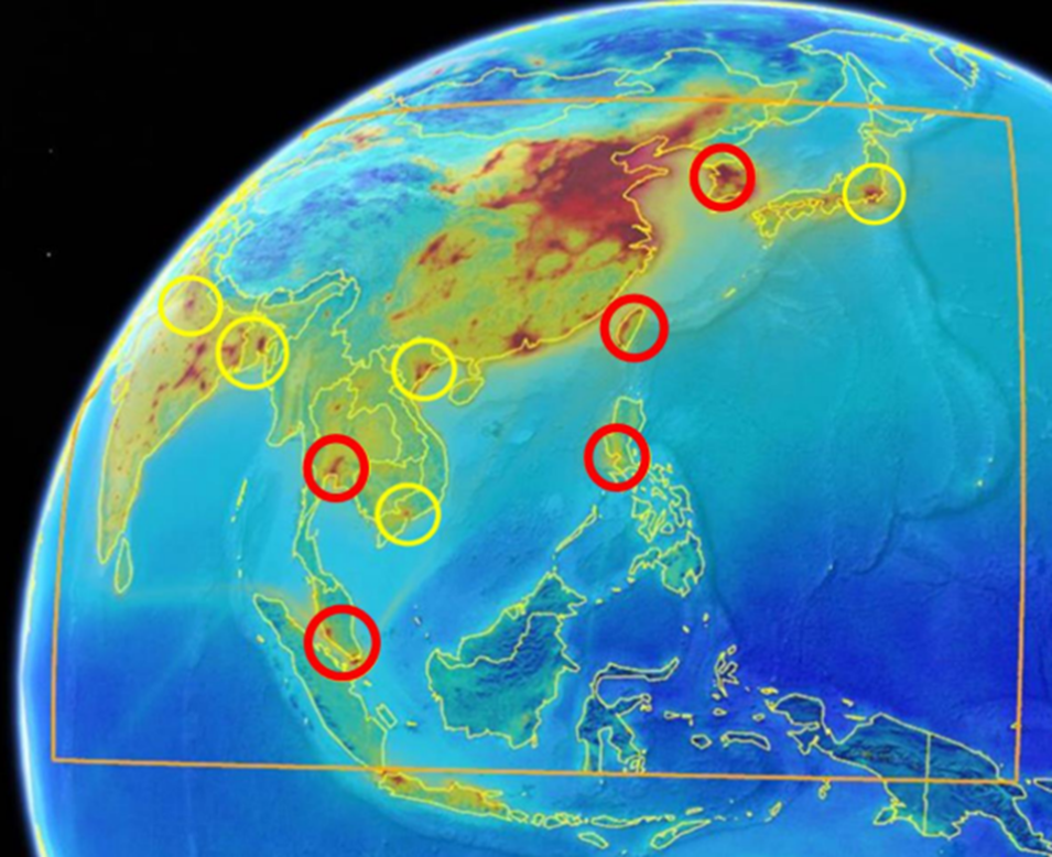
This graphic shows the observing domain for GEMS (orange box) and candidate locations for airborne sampling during ASIA-AQ. Yellow circles indicate the original areas of interest and engagement, while red circles indicate the locations still under negotiation for flight sampling. Candidate locations include Seoul, South Korea; Tokyo, Japan; Taiwan; Manila, Philippines; Hanoi and Ho Chi Minh City, Vietnam; Bangkok, Thailand; Kuala Lumpur, Malaysia; Singapore; Dhaka, Bangladesh; and Kolkata and Delhi, India. Credit: ASIA-AQ

Global Hydrometeorology Resource Center Distributed Active Archive Center (GHRC DAAC)

ALOFT ER-2 Navigation Dataset Released

NASA’s GHRC DAAC released the NASA ER-2 Navigation dataset from the ALOFT—Airborne Lightning Observatory for the Fly’s Eye GLM Simulator (FEGS) and Terrestrial Gamma-Ray Flashes (TGFs)—campaign. The dataset contains information recorded by the onboard navigation and data collection systems of NASA's ER-2 high-altitude research aircraft. In addition to typical navigation data (e.g., date, time, latitude/longitude, and altitude), the dataset also contains outside meteorological parameters such as wind speed, wind direction, and temperature. The ALOFT field campaign aimed to observe TGFs in one of the most TGF-intense regions on the planet, to observe gamma-ray glows in thunderstorms and their relation to TGFs, to perform International Space Station Lightning Imaging Sensor (LIS) and Geostationary Lightning Mapper (GLM) validation using improved suborbital instrumentation, to evaluate new design concepts for next-generation spaceborne lightning mappers, and to make combined microwave and lightning measurements of tropical convection from a suborbital platform. The ALOFT navigation dataset files are available from June 15, 2023, through July 31, 2023, and are in ASCII format.

Access data and more information about the ALOFT campaign.

Image
Image Caption

NASA Armstrong’s ER-2 aircraft deploys for its ALOFT mission. The ER-2 will fly at high altitudes above the Floridian coastline to collect data about the energetic characteristics and behavior of lightning and thunderclouds. A NASA pilot will operate the aircraft while scientists from the University of Bergen, Norway will interpret the data from the ground. Credit: NASA/Carla Thomas

Geostationary Lightning Mapper Events and Flashes Dataset Now Available

The Geostationary Lightning Mapper (GLM) Events and Flashes dataset is now available from NASA’s GHRC DAAC. The data, which were collected from the GLM instrument on NOAA’s GOES-16 and GOES-17 satellites, consist of the number and size of lightning flashes and events. The data are available in netCDF-4 and HDF-5 formats and are available as Level 1b events (raw) and Level 2 flashes (processed). The data cover the period from March 15, 2021, through March 18, 2021. 

Access data and more information about the GLM Events and Flashes Dataset.

Goddard Earth Sciences Data and Information Services Center (GES DISC)

Copernicus Sentinel-5P TROPOMI Level-2 Tropospheric Ozone and Methane Products Released

NASA's GES DISC, in coordination with the European Space Agency (ESA) and the Copernicus Sentinel Project, released the Sentinel-5 Precursor (S5P) TROPOspheric Monitoring Instrument (TROPOMI) Level 2 Methane and Tropospheric Ozone data products.

The Copernicus S5P/TROPOMI methane retrieval is for the non-time-critical (NTC) data stream only, and its main outputs include the column-averaged dry air mixing ratio of methane, the random error, and the bias-corrected dry air methane fraction data based on the retrieved surface albedo.

The main outputs of the Copernicus S5P/TROPOMI tropospheric ozone product include the tropospheric ozone column, upper tropospheric ozone, stratospheric ozone column, corresponding errors, and retrieval quality flags. 

Access data and more information about the Sentinel-5P TROPOMI Tropospheric Ozone and Methane Products.

Image
Image Caption

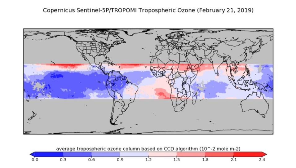
Global image of the Copernicus Sentinel-5P/TROPOMI Tropospheric Ozone product, acquired on February 21, 2019. Red areas on the map indicate the presence of higher ozone concentrations. Blue areas indicate lesser concentrations. Credit: GES DISC 

Copernicus Sentinel-5 Precursor (S5P) Near Real-Time Datasets Now Available

A suite of Sentinel-5 Precursor (S5P) TROPOspheric Monitoring Instrument (TROPOMI) Near Real-Time Level 1B, and Level 2 are now available from GES DISC. Released in coordination with the European Space Agency (ESA) and the Copernicus Sentinel Project and NASA's Land, Atmosphere Near real-time Capability for Earth observation (LANCE), these products are typically available within three hours of measurement and are intended for rapid turnaround assessment. Users should note that because these datasets are intended for rapid assessments, they are only archived for seven days. Users who wish to do a more rigorous assessment should use the standard offline versions of these products.

The data product suite includes:

Learn more about the Sentinel-5 Precursor (S5P) near-real-time datasets.

TROPICS Cubesats 1, 3, 5, 6, 7 D-MINT 183 Data Products Released 

GES DISC released a suite of Deep Multispectral INtensity of Tropical Cyclones (TCs) estimator with 183 GHz brightness temperatures (D-MINT183) datasets from the Time-Resolved Observations of Precipitation structure and storm Intensity with a Constellation of Smallsats (TROPICS) mission.

Comprised of five Level 2B datasets (one for each of the TROPICS Cubesats), each D-MINT183 dataset estimates two primary tropical cyclone variables: Minimum Sea Level Pressure (MSLP) and Maximum Sustained Winds (MSW).

Access data and more information about the D-MINT183 product suite.

Land Processes Distributed Active Archive Center (LP DAAC)

VIIRS BRDF/Albedo Version 2 Products Now Available in AppEEARS

NASA's LP DAAC announced the release of the Application for Extracting and Exploring Analysis Ready Samples (AppEEARS) Version 3.76. This release adds the Visible Infrared Imaging Radiometer Suite (VIIRS) Bidirectional Reflectance Distribution Function (BRDF) Albedo products Version 2 from the Suomi National Polar-orbiting Partnership (Suomi NPP) and NOAA-20 satellites. View a list of VIIRS products added to AppEEARS.

Read more about this release.

VIIRS Version 2 FIre Light Detection Algorithm (FILDA) Modified Combustion Efficiency (MCE) product Suite Released

LP DAAC released the Visible Infrared Imaging Radiometer Suite (VIIRS) Version 2 FIre Light Detection Algorithm (FILDA) Modified Combustion Efficiency (MCE) product suite. The VIIRS Version 2 release includes annual data products from both the Suomi National Polar-orbiting Partnership (Suomi NPP) and NOAA-20 (aka: JPSS1) satellites. Enhanced visible band observation in these datasets can be used to detect smaller and cooler fires. 

The datasets included in the product suite are: 

  • VIIRS/NPP FILDA-2 Fire Modified Combustion Efficiency Product 6-min Level 2 Swath 750-meter dataset (VNP47MOD)
  • VIIRS/NPP FILDA-2 Fire Modified Combustion Efficiency Product 6-min L2 Swath 375m dataset (VNP47IMG)
  • VIIRS/JPSS1 FILDA-2 Fire Modified Combustion Efficiency Product 6-min Level 2 Swath 750m dataset (VJ147MOD)
  • VIIRS/JPSS1 FILDA-2 Fire Modified Combustion Efficiency Product 6-min L2 Swath 375m dataset (VJ147IMG)

Learn more about the FILDA Modified Combustion Efficiency (MCE) product suite.

Image
Image Caption

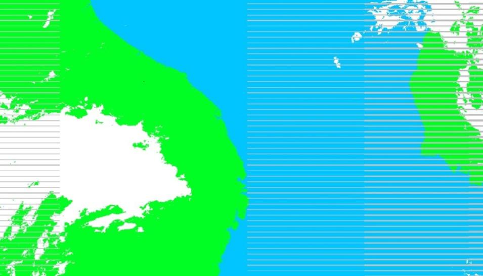
This graphic shows VIIRS FIre Light Detection Algorithm (FILDA-2) fire mask data from the Fire Modified Combustion Efficiency Product over Madagascar on February 12, 2025. Credit: LP DAAC

VIIRS Version 1 Land Surface Reflectance, Leaf Area Index, Fraction of Photosynthetically Active Radiation, Land Surface Temperature, and Active Fires Product Distribution to End in April

LP DAAC announced it will cease distribution of VIIRS Version 1 Land Surface Reflectance (LSR), Leaf Area Index (LAI) and Fraction of Photosynthetically Active Radiation (FPAR), Land Surface Temperature and Active Fires Products on April 8, 2025. These products will no longer be available for search and download from NASA’s Earthdata Search, Data Pool, or AppEEARS. Users are highly encouraged to transition to the VIIRS Version 2 data products which includes data from both the Suomi National Polar-orbiting Partnership (Suomi NPP) and the NOAA-20 satellites.

Learn more about transitioning from VIIRS Version 1 to Version 2.

ASTER Resumes Limited Operations

LP DAAC announced that the Advanced Spaceborne Thermal Emission and Reflection Radiometer (ASTER) aboard NASA’s Terra platform has resumed limited operations. On November 28, 2024, one of Terra's power-transmitting shunt units failed. This resulted in ASTER being put into safe mode. After investigation and monitoring of platform battery status, the Terra Flight Operations Team (FOT) determined there was sufficient power to resume imaging with ASTER’s Visible and Near Infrared (VNIR) instrument. As such, ASTER began collecting VNIR data on January 17, 2025. However, there is a data gap in ASTER acquisitions from November 28, 2024, through January 16, 2025. On March 03, 2025, LP DAAC released ASTER VNIR-only data from January 17, 2025, to the present.

Learn more about ASTER data availability.

National Snow and Ice Data Center Distributed Active Archive Center (NSIDC DAAC)

NSIDC to Add 16 Datasets from the SMAP Related collection to NASA Earthdata Cloud on April 8, 2025

NASA's NSIDC DAAC will add 16 datasets from the Soil Moisture Active Passive (SMAP)-related collection to the Earthdata Cloud on April 8, 2025. After that date, the Earthdata Cloud HTTPS data access URL will be available from each dataset landing page using the HTTPS File System link under Data Access and Tools.

Learn more about the addition of SMAP datasets to the Earthdata Cloud.

Image
Image Caption

These maps of global soil moisture were created using data from the radiometer instrument on NASA's Soil Moisture Active Passive (SMAP) observatory. Each image is a composite of three days of SMAP radiometer data, centered on April 15, 18, and 22, 2015. The images show the volumetric water content in the top 2 inches (5 centimeters) of soil. Wetter areas are blue and drier areas are yellow. White areas indicate snow, ice or frozen ground. Credit: NASA/JPL-Caltech/GSFC

NSIDC to Add SMMR and SSM/I-SSMIS collection to NASA Earthdata Cloud on April 8, 2025

NSIDC DAAC announced it will add 26 datasets from Nimbus-7's Scanning Multichannel Microwave Radiometer (SMMR) and the Defense Meteorological Satellite Program's Special Sensor Microwave/Imager (SSM/I)-Special Sensor Microwave Imager/Sounder (SSMIS) collection to NASA's Earthdata Cloud on April 8, 2025. After that date, the Earthdata Cloud HTTPS data access URL will be available from each dataset landing page using the HTTPS File System link under Data Access and Tools.

Learn more about the addition of these datasets to the Earthdata Cloud.

New Version 1.1 of Near Real-Time MODIS/Terra Level 3 Global Daily 500m SIN Grid Snow Cover, Grain Size, and Dust Radiative Forcing Dataset Available

A new version of the near real-time Moderate Resolution Imaging Spectroradiometer (MODIS)/Terra Level 3 Global Daily 500m SIN Grid Snow Cover, Grain Size, and Dust Radiative Forcing dataset—Version 1.1—is available from NASA’s NSIDC DAAC. This dataset contains the following parameters: snow fraction, snow grain size, vegetation fraction, rock fraction, ice fraction, shade fraction, deltavis, radiative forcing, and optical snow grain size. Version 1.1 data are forward processing and will be updated once a day. NSIDC DAAC is working to backfill data from November 1, 2023, through the present, so users will see missing data filled in over the next few weeks. These data are provided in netCDF format.

Access data and more information about version 1.1.

NSIDC Retires VIIRS Version 1 (Collection 1)

NSIDC DAAC announced it will retire the Visible Infrared Imaging Radiometer Suite (VIIRS) Version 1 (Collection 1) datasets on April 8, 2025. Once retired, the data will no longer be accessible, but all related documentation will remain available on the dataset web page for future reference. Users are advised to use VIIRS Version 2 (Collection 2), which includes 13 new Level 2 and Level 3 datasets from both the NASA/NOAA Suomi National Polar-orbiting Partnership satellite and NOAA-20 satellites.

Learn more about the retirement of the VIIRS Version 1 (Collection 1).

NSIDC Added MODIS Version 6.1 Collections to the Earthdata Cloud on March 18, 2025

NSIDC DAAC added 22 datasets from the MODIS Version 6.1 collections to NASA’s Earthdata Cloud on March 18, 2025. Although these datasets will continue to be available via their current URLs and workflows, these legacy access methods will be retired soon. Therefore, users are encouraged to update their direct download workflows, including any data download scripts, to use the new Earthdata Cloud HTTPS location after March 18, 2025. After that date, the Earthdata Cloud HTTPS data access URL will be available from each dataset landing page using the HTTPS File System link under Data Access and Tools.

Learn more about the addition of these data to the Earthdata Cloud.

DMSP SSM/I-SSMIS Daily Polar Gridded Brightness Temperatures, Version 6 Dataset Updated

NSIDC DAAC updated the Defense Meteorological Satellite Program (DMSP) Special Sensor Microwave/Imager (SSM/I)-Special Sensor Microwave Imager/Sounder (SSMIS) Daily Polar Gridded Brightness Temperatures, Version 6 dataset through January 5, 2025. This dataset provides daily gridded brightness temperatures derived from passive microwave sensors and distributed in a polar stereographic projection. NSIDC DAAC produces daily gridded brightness temperatures from orbital swath data generated by the SSM/I aboard the DMSP F8, F11, and F13 satellites and the SSMIS aboard the DMSP F17 and F18 satellites.

Access data and more information about the dataset update.
Image
Image Caption

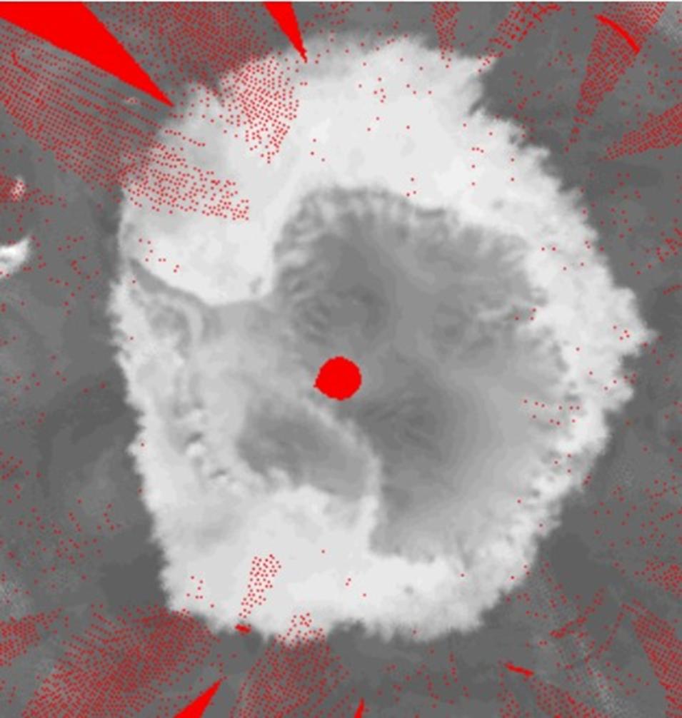
A sample brightness temperature image from the 19GHz-horizontally polarized channel of the Defense Meteorological Satellite Program (DMSP) F08 satellite on October 10, 1988, in Antarctica, where missing data are shown in red and brightness temperature data in grayscale. Credit: NSIDC DAAC

Oak Ridge National Laboratory Distributed Active Archive Center (ORNL DAAC)

ABoVE: Soil Moisture and ALT Field Collection Protocols and Probe Calibration Dataset Released

NASA’s ORNL DAAC released the Arctic-Boreal Vulnerability Experiment (ABoVE) Soil Moisture and ALT Field Collection Protocols and Probe Calibration dataset, which contains soil moisture sampling protocols and calibration algorithms for Campbell Scientific Hydrosense-I and II units used at burned and unburned sites in the ABoVE project domain. The soil moisture sampling protocols document provides guidance for sampling in-situ soil moisture to relate to synthetic aperture radar (SAR) data collections. Two additional documents describe algorithms for calibrating handheld Hydrosense units used to measure volumetric water content in soils. One calibration document applies to organic soils in fire-affected sites of the Northwest Territories and Alaska. A second document provides calibrations for samples collected in non-burned tundra, boreal bog, fen, upland deciduous, and conifer sites located in Alberta and tundra sites in Alaska.

Access data files and more information about the ABoVE dataset.

Western Diversity Time Series: AVIRIS-Classic Level 2B Corrected and Georectified Surface Reflectance, 2013-2018 Dataset Now Available

The Western Diversity Time Series: AVIRIS-Classic Level 2B Corrected and Georectified Surface Reflectance, 2013-2018 dataset is now available from ORNL DAAC. This dataset includes Level 2 surface reflectance imagery from the AVIRIS-Classic instrument collected for NASA's Western Diversity Time Series (WDTS) Project over California and Nevada in 2013 to 2018. AVIRIS-Classic imagery was collected on the NASA ER-2 from altitude of 19,800 meters, yielding imagery with 15-20-meter ground sample distance. The imagery data are provided in ENVI format. Ground control points used in georectification along the BRDF and topographic correction coefficients are provided in JSON files.

Access data and more information about the AVIRIS dataset.

Image
Image Caption

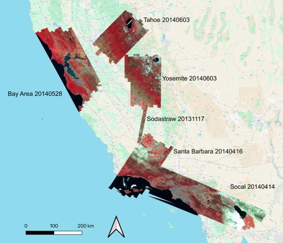
This graphic shows surface reflectance imagery from the AVIRIS-Classic instrument, which was collected for NASA's Western Diversity Time Series (WDTS) Project over California and Nevada from 2013 to 2018. Credit: ORNL DAAC

ABoVE: Alaska Lake and Pond Occurrence Dataset Now Available

The Alaska Lake and Pond Occurrence Dataset (ALPOD) from ABoVE is now available from ORNL DAAC. The dataset provides a spatially explicit map of lakes and ponds across Alaska and their seasonal fluctuations. The core product is an open water occurrence raster that: (a) separates lakes and ponds from other components of the landscape (e.g., rivers and wetlands); (b) is built from Sentinel-2 imagery and has 10-meter resolution; and (c) records the percentages of time that each pixel was open water and attached to a lake or pond during the 2016-2021 ice-free seasons at near-daily temporal resolution. 

The ALPOD dataset, which also includes a vector product defined using a 25 percent occurrence threshold, is suitable for investigations of individual water bodies as well as lake and pond patterns across Alaska. The data are provided in GeoTIFF and shapefile formats.

Access data and information about the Alaska Lake and Pond Occurrence Dataset.

ABoVE: AVIRIS-3 Imaging Spectroscopy for Alaska and Canada, 2023 Dataset Released

ORNL DAAC released the ABoVE AVIRIS-3 Imaging Spectroscopy for Alaska and Canada, 2023 dataset. The dataset includes Level 1B radiance and Level 2A surface reflectance imagery acquired by the Airborne Visible/Infrared Imaging Spectrometer-3 (AVIRIS-3) instrument over portions of Alaska and northwestern Canada in 2023. The imagery data are provided in ENVI format along with a GeoJSON showing imagery boundaries.

Access data and more information about this ABoVE dataset.

Potential Areas of Gas Seepage Detected by SAR in Lakes near Fairbanks, Alaska Dataset Now Available

The Potential Areas of Gas Seepage Detected by SAR in Lakes near Fairbanks, Alaska dataset is now available from ORNL DAAC. This dataset includes maps and locations of potential gas seepage in lakes within the immediate and surrounding area around Fairbanks, Alaska, a region underlain by discontinuous permafrost and characterized by thermokarst lake formation. (Note: The term thermokarst refers to a type of terrain formed by the thawing of ice-rich permafrost.) 

This dataset is based on a new remote sensing method that was used for detecting potential gas seepage, defined as areas of suspected perennial ebullition, by using a previously ground-truthed seep that appeared as a high-backscatter perennial feature in winter L-band Synthetic Aperture Radar (SAR) data from 2006 to 2011. Based on threshold values determined by the sigma-naught backscatter of this training seep, 1,690 areas of potential seepage were detected in 459 lakes out of 658 lakes analyzed. Results were validated through a different ground-truthed seep. The data are provided in shapefile format.

Access data and more information about this SAR dataset.

Image
Image Caption

This graphic shows examples of SAR-detected areas of potential perennial ebullition (orange) in several lakes (black) within the Goldstream Valley area of Fairbanks, Alaska. The areas of potential ebullition indicate possible locations of methane-rich gas (background: 60-meter NED Hillshade, USGS, 2018). Credit: ORNL DAAC

Delta-X: Soil Accretion Rates from Cs-137 Activity and NUMAR Validation, Mississippi River Delta, Louisiana Dataset Released

ORNL DAAC released the Delta-X: Soil Accretion Rates from Cs-137 Activity and NUMAR Validation, Mississippi River Delta, Louisiana dataset, which offers measurements of Cesium-137 (137Cs) activity sampled from sites in the Atchafalaya and Terrebonne Basins along the southern coast of Louisiana. The data are provided in comma separated values (CSV) format.

The Delta-X mission is a 5-year NASA Earth Venture Suborbital-3 mission to study the Mississippi River Delta in the United States, which is growing and sinking in different areas. River deltas and their wetlands are drowning as a result of sea level rise and reduced sediment inputs. The Delta-X mission will determine which parts will survive and continue to grow, and which parts will be lost. Delta-X begins with airborne and in situ data acquisition and carries through data analysis, model integration, and validation to predict the extent and spatial patterns of future deltaic land loss or gain.

Access data and more information about this Delta-X dataset.

Wetland Salinity Maps of Select Estuary Sites in the United States, 2020 Dataset Released

ORNL DAAC released the Wetland Salinity Maps of Select Estuary Sites in the United States, 2020 dataset, which provides gridded average annual wetland salinity concentrations in practical salinity units at 30-meter resolution within 24 coastal estuary sites in the United States predicted for 2020. Salinity in estuaries can serve as a proxy for sulfate concentration, which can inhibit methanogenesis. Data were derived from a hybrid approach to mapping salinity as a continuous variable using a combination of physical watershed and stream characteristics, optical remote sensing based on vegetation characteristics, and climate variables. Data are provided in cloud-optimized GeoTIFF format covering 33 Hydrologic Unit Code 8-digit (HUC8) watersheds to the extent of palustrine and estuarine wetlands as defined by NOAA's 2016 Coastal Change Analysis Program (C-CAP) Coastal Land Cover layer. Additionally, model outputs are provided in comma separated values (CSV) files, and code scripts are provided in a compressed (*.zip) file.

Access data and more information about the Wetland Salinity Maps of Select Estuary Sites in the United States, 2020 dataset.

Image
Image Caption

This data visualization shows salinity modeled in practical salinity units in the Sapelo Island National Estuarine Research Reserve watershed in coastal Georgia. The brighter the color, the higher the salinity. Credit: ORNL DAAC

Physical Oceanography Distributed Active Archive Center (PO.DAAC)

NASA-SSH Sea Surface Height from Standardized Reference Missions Only Version 1 Datasets Released

NASA's PO.DAAC released the NASA Sea Surface Height (SSH) from Standardized Reference Missions Only Version 1 datasets. Two distinct datasets are available: Along-Track Sea Surface Height and Simple Gridded Sea Surface Height. The Along-Track Sea Surface Height dataset provides along-track observations of sea surface height, collected approximately once per second (1 Hz), and parsed into daily files. The Simple Gridded Sea Surface Height dataset provides 2D maps of sea surface height anomaly once every 7 days. These grids are produced on a 0.5-degree latitude and longitude grid, and consist of 10 days’ worth of observations, which cover approximately 1 complete repeat cycle of observations from the reference missions. Both datasets cover the global ocean up to the most poleward extent of the reference mission orbits. The data begin in October 1992 and continue through the present, and their files are distributed in netCDF4 format.

Access data and more information about the SSH datasets.

Details

Last Updated

Published