Canadian Wildfires and Recent PyroCb Events

Pyrocumulonimbus (pyroCb) events (fire thunderstorms) caused by wildfires in western Canada were detected by the Ozone Mapping and Profiler Suite (OMPS) instrument July 19-24, 2024.

As spring turned to summer, fires in western Canada continued to increase in intensity. A series of pyrocumulonimbus (pyroCb) events in western Canada that occurred July 19-24, 2024, contributed to a vast amount of smoke that is affecting much of Canada and a large part of the Midwestern United States.

PyroCbs are thunderstorms that are created or enhanced by wildfires. They can lift large plumes of smoke high into the air, often reaching the stratosphere. These smoke plumes can travel long distances, affecting air quality thousands of kilometers from their sources. The location and movement of these plumes can be monitored from space using measurements acquired by instruments such as the Ozone Mapping and Profiler Suite (OMPS) aboard the NASA/NOAA Suomi National Polar-orbiting Partnership (Soumi NPP), NOAA-20, and NOAA-21 satellites.

While OMPS was primarily designed to measure atmospheric ozone, it also can be used to detect atmospheric aerosols such as volcanic ash, dust, and smoke. One particular OMPS product, the Aerosol Index (AI), is extremely useful for monitoring and tracking the movement of such aerosols because it can detect them over any type of land surface (including ice) and in clouds.

In the series of images below spanning July 19 (upper left image) to July 24 (lower right image), NOAA-21 OMPS AI measurements are shown with true-color imagery from the NOAA-21 Visible Infrared Imaging Radiometer Suite (VIIRS) instrument. Higher AI values are indicated in yellow/dark yellow and represent higher density (and altitude) smoke.
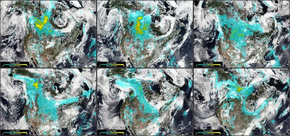
NOAA-21 six panel Ozone Mapping and Profiler Suite (OMPS) Aerosol Index July 19-24, 2024.
Image Caption

NOAA-21 OMPS AI values (representing smoke) overlain on true-color NOAA-21 VIIRS imagery for July 19-24, 2024. Smoke from the wildfires burning in western Canada can be seen over large areas of Canada and the northern U.S. Credit: Dr. Colin Seftor, NASA OMPS science team.

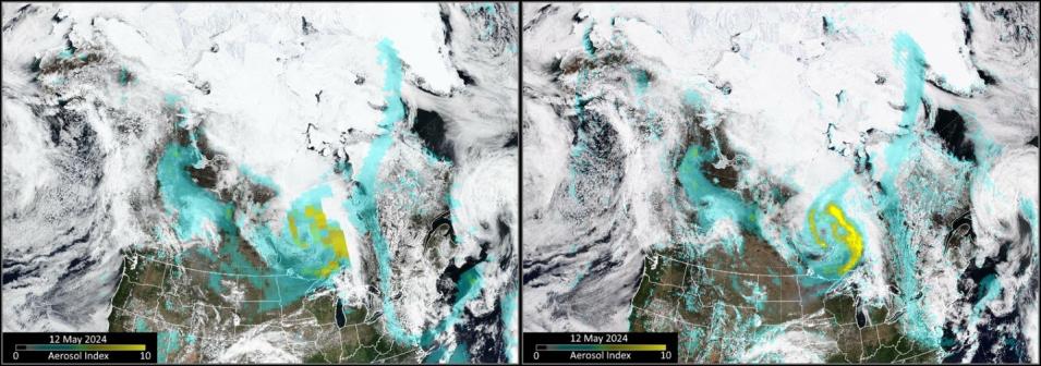
The NOAA-20 and NOAA-21 OMPS AI products have a higher spatial resolution than the Suomi NPP OMPS AI product. The figure below shows the difference between the Suomi NPP OMPS AI product (left image) and the higher level of detail provided by the NOAA-21 OMPS AI product (right image) in an image acquired on May 12, 2024.

Comparison of Suomi-NPP OMPS and NOAA-21 OMPS Aerosol Index observations for May 12.
Image Caption

Comparison of AI measurements from the Suomi NPP (left) and NOAA-21 (right) OMPS instruments. The NOAA-21 observations have a higher spatial resolution and provide a greater level of detail of the smoke plumes. Credit: Dr. Colin Seftor, NASA OMPS science team.

OMPS near real-time AI data are produced by NASA's Land, Atmosphere Near real-time Capability for Earth observations (LANCE), which provides low-latency data to support users interested in monitoring a wide range of natural and human-created phenomena.

Details

Last Updated

Published