Urban Pollution and Heat: Houston, We Have a Problem

While particulate pollution decreased overall across the greater Houston metropolitan area, social vulnerability from pollution and heat is increasing in more urban areas.

This post highlights a peer-reviewed journal article discussing the synergy of urban heat, pollution, and social vulnerability in Houston, TX. The article is an outgrowth of a data story, Aerosols and Their Impacts on Houston, TX, published on the NASA Visualization, Exploration, and Data Analysis (VEDA) dashboard. VEDA uses Earth science data for storytelling through visual exploration of data that are transformed into cloud-native formats. Two of the VEDA dashboard thematic areas are environmental justice and air pollution. 

Andrew Blackford, a graduate student in the Department of Atmospheric and Earth Science at the University of Alabama in Huntsville, used NASA Earth science data products to visually explore the relationship between heat, air pollution, and social vulnerability in the Houston metropolitan area over the first two decades of the 21st century. After the publication of the story on VEDA, he and his co-authors conducted an in-depth analysis that led to the peer-reviewed journal publication.

Urban Heat Islands and Pollution

Houston, one of the largest metropolitan areas in the United States, has experienced remarkable urban growth over the past two decades. This expansion has seen the addition of approximately 1,345 square kilometers of developed land—an area nearly twice the size of New York City—to the Houston metropolitan area (HMA). However, with this rapid growth comes a set of environmental challenges that are becoming increasingly difficult to ignore.

As Houston has grown, so too has the urban heat island (UHI) effect—a phenomenon where urban areas are significantly warmer than their rural surroundings. An analysis by Blackford and his co-authors found that as the city expanded, the UHI effect also spread, even affecting areas that were already developed prior to 2000. This has resulted in higher maximum and minimum air temperatures across the city.

Alongside the UHI effect, urban pollution islands (UPI) also have become a concern. While overall particulate pollution in the HMA has decreased over time, urban areas have seen less significant reductions compared to rural regions. In particular, changes in air quality in urban areas have shown greater variability, with more uniform and sharp reductions during the latter part of the study period.

Although the Clean Air Act Amendment of 1990 contributed to reductions in particulate pollution, the increase in vehicle traffic and other urban growth-related factors seems to have offset some of these gains. This aligns with similar studies that have identified local air pollution pockets in the HMA, which are not always detected by existing air quality monitoring networks.
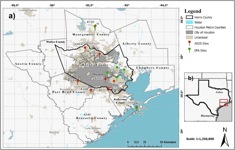
Map showing the counties comprising the Houston metropolitan area; colored dots indicate the location of air quality sensors
Image Caption

Image from Blackford, et al., showing the spatial extent of the study area. The study area includes the city of Houston (gray area in the center of the image covering much of Harris County) and the surrounding counties, which comprise the Houston metropolitan area (HMA). Red and green dots indicate the locations of automated surface observing stations (ASOS; red dots) and Environmental Protection Agency (EPA) monitoring stations (green dots). Credit: Blackford, et al., 2024.

The Human Impact: Social Vulnerability and Environmental Inequality

The spread of UHIs and UPIs has not occurred in a vacuum. The research by Blackford and his colleagues highlights that these environmental issues exacerbate social vulnerability, particularly in the context of climate change. Population growth in the HMA has been accompanied by higher levels of social vulnerability, with disadvantaged communities facing greater exposure to both heat stress and pollution.

This is especially concerning when considering the potential health impacts. For instance, a recent study linked approximately 700 annual deaths to heat stress across the United States. As heatwaves become more frequent and intense—potentially increasing heatwave intensity by an additional 0.55 ºC in the HMA—the risk of heat stress-related deaths could rise significantly.

Moreover, the Houston study suggests that the combined exposure to heat stress and particulate pollution could increase the risk of mortality by as much as 250%. The compounded effects of UHI, UPI, and social vulnerability create a troubling scenario, particularly for populations that are already at higher risk.

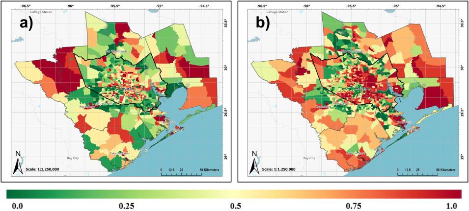
Side by side maps showing the Houston metro area in 2000 (left map) and 2020 (right map) for U.S. census tracts; colors in the maps indicate Social Vulnerability Index values.
Image Caption

Image from Blackford, et al., showing Social Vulnerability Index (SVI) values for census tracts in the HMA for 2000 (a) and 2020 (b). The SVI ranges from 0.0 (shown in green) to 1.0 (shown in red). Census tracts were categorized based on SVI percentile rankings: 0.0–0.25 (least socially vulnerable), 0.25–0.50, 0.50–0.75, and 0.75–1.0 (most socially vulnerable). The spatial distribution of the SVI revealed a significant increase in social vulnerability within more urban regions of the HMA between 2000 and 2020. Credit: Blackford, et al., 2024.

Looking Ahead: The Future of Urban Growth

The United Nations projects that by 2050, 87% of Americans and 68% of the global population will live in urban areas. In the HMA, urban land cover is expected to continue expanding in the coming decades, according to the EPA's Integrated Climate and Land Use Scenarios (ICLUS) dataset. If no action is taken to mitigate the effects of UHIs and UPIs, these impacts are likely to worsen, further deepening environmental inequalities.

The study by Blackford and his co-authors underscores the need for strategies to address these challenges, such as increasing green spaces that can help reduce the UHI effect. Additionally, the combination of satellite data and high-resolution mapping techniques can be instrumental in identifying environmental inequalities and related health risks. This approach not only informs the development of mitigation policies but can also be applied to other cities experiencing similar urban growth patterns.

As cities like Houston continue to grow, it is imperative to address the environmental and social impacts that come with urban expansion. By doing so, we can help create healthier, more equitable urban environments for all.

Related Datasets

Details

Last Updated

Published

Data Center/Project

Socioeconomic Data and Applications Center (SEDAC)