Explore New Aerosol Layers in NASA Worldview

NASA Worldview added four layers from the Aerosol Robotic Network (AERONET) program to provide ground-based measurements of aerosol optical depth (AOD) and Angstrom parameter.

NASA Worldview has expanded its suite of satellite-based remote sensing measurements of aerosol optical depth (AOD) and Angstrom parameter to include four new layers of ground-based measurements from the global Aerosol Robotic Network (AERONET) program. Users can now quickly and easily compare ground based measurements to satellite based measurements in NASA Worldview to validate their findings.

AERONET is a federated network of ground-based remote sensing aerosol sensors established by NASA and the PHOtométrie pour le Traitement Opérationnel de Normalisation Satellitaire (PHOTONS) in 1993. The federation includes collaborators from a global network of national agencies, institutes, universities, individual scientists, and partners. AERONET provides a long-term, public domain database of aerosol optical, microphysical, and radiative properties.

Atmospheric Aerosols and their Measurement

Aerosols are suspended liquid or solid particles that are small enough to be easily transported by air currents. Water vapor, smoke, dust, sea salt, and industrial pollutants are all examples of aerosols. It is important to monitor atmospheric aerosols as these particles can compromise human health when inhaled, particularly in individuals with asthma or other respiratory illnesses. Aerosols also impact weather and climate by cooling or warming Earth by helping or preventing clouds from forming.

Each AERONET ground-based remote sensing aerosol network site consists of a Sun photometer and a satellite transmission system. Sun photometer measurements of solar radiation provide information to calculate columnar AOD. AOD can be used to compute columnar water vapor (precipitable water) and to estimate the aerosol particle size using the Angstrom parameter relationship.
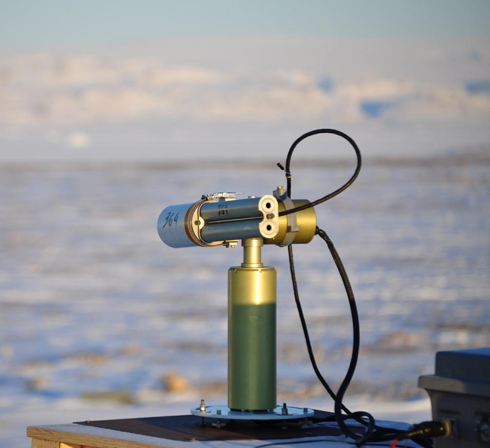
Photograph of a sun photometer for the AERONET program at Thule Air Base
Image Caption

Sun photometer at Thule Air Base (now known as Pituffik Space Base), Greenland. Credit: AERONET.

AOD is a dimensionless number ranging from <0.0 to 5.0 that indicates the level at which aerosols prevent light from traveling through the atmosphere. From an observer on the ground, an AOD of less than 0.1 is characteristic of clear blue sky, bright Sun, and maximum visibility. As AOD increases to 0.5, 1.0, and greater than 3.0, aerosols become so dense that the Sun is obscured.

The Angstrom parameter provides additional information related to the aerosol particle size. Values range from <0.0 to >=2.5, with larger values indicating smaller particle sizes. Angstrom parameter values < 1 suggest a dominance of coarse particles (e.g., dust, ash, sea spray); values > 1 suggest a dominance of fine particles (e.g., smoke, industrial pollution).

AERONET Layers in NASA Worldview

Four AERONET data layers (two near real-time and two daily) are available in Worldview:

Selecting the Layers

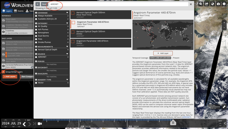
To load the AERONET layers, simply click on the orange "Add Layers" button (circled in red), and type in "AERONET" in the search bar. Selecting any of the four AERONET layers loads it into the Layer List.

Screenshot of Worldview showing how to add the AERONET layers to the map
Image Caption

Working with the Layers in Worldview

The AERONET near real-time data layers display site readings from the past hour, with inactive sites denoted by gray circles on the map.

Daily data layers display daily average values based on the Universal Coordinated Time (UTC) solar day. Both AOD and Angstrom parameter daily data are from the Level 1.5 data quality level for AERONET ground-based remote sensing aerosol network sites. AERONET Level 1.5 data are automatically cloud cleared but may not have final calibration applied. As a result, daily AERONET data are not quality assured.

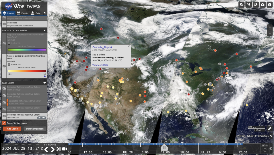
Screenshot of Worldview displaying AERONET sites in the USA and corresponding Aerosol Optical Depth values.
Image Caption

The example above shows high aerosol optical depth values due to wildfires and smoke in the U.S. Pacific Northwest. Colored circles indicate AOD values; gray circles indicate inactive sites. Credit: NASA Worldview.

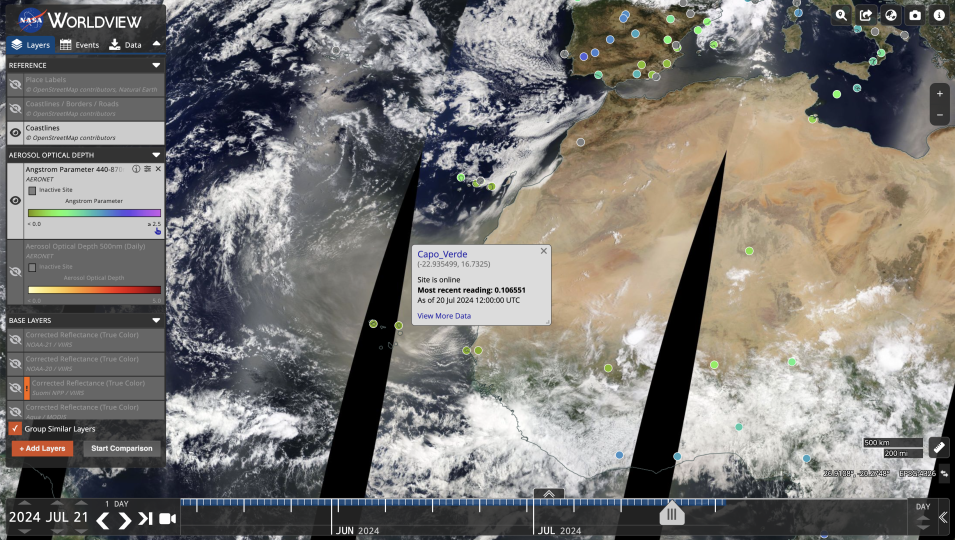
Screenshot of AERONET sites in northern Africa and corresponding Angstrom parameter values.
Image Caption

The example above shows dust blowing off the coast of northwestern Africa from the Sahara Desert over the island of Capo Verde. Colored circles indicate Angstrom parameter values; gray circles indicate inactive sites. The Angstrom parameter site reading at Capo Verde is below 1 (dark green), which indicates fine particles. Credit: NASA Worldview.

Details

Last Updated

Published