Mobile Menu
Skip to main content
  • About
  • Data
  • Collaborate
  • Learn

Earthquakes and Volcanoes

  1. Learn
  2. Data Toolkits
  3. Disasters Data Toolkit
  4. Earthquakes and Volcanoes
Share on Twitter Share on Facebook Share on Pinterest

Geological forces below the surface of the Earth have created some of our most inspiring landscapes—the Cascade Range, the Himalayas, Yellowstone, the Hawaiian Islands, the Galapagos Islands, and many more—but these same forces often also threaten our way of life and devastate communities.

NASA Earth observations help geologists and decision makers understand the movement of the Earth, monitor risk and vulnerability of populations, and

Discover Data

Aura Ozone Monitoring Instrument (OMI) Sulfur Dioxide Daily Total Column

Aura Ozone Monitoring Instrument (OMI) Sulfur Dioxide Daily Total Column in Earthdata Search. Earthdata Search is a data discovery and data access application that enables access to NASA Earth Observing System Data and Information System (EOSDIS) Earth science data distributed by EOSDIS Distributed Active Archive Centers (DAACs).

Discover Earthquake and Volcano Data

Gridded Population of the World,Version 4(GPWv4): Population Density consists of estimates of human population density based on counts consistent with national censuses and population registers for the years 2000, 2005, 2010, 2015, and 2020. Credit Socioeconomic Data and Applications Center

Socioeconomic Impacts from Hazards

Socioeconomic data help assess the exposure and vulnerability of a community to a disaster. Exposure is the presence of people, ecosystems, and infrastructure in places that could be adversely affected by a disaster. Vulnerability is the propensity to be adversely affected by a disaster.

Earthquake Hazards

  • Discover Earthquake-related Data in Earthdata Search
  • Earthquake Data at NASA's Socioeconomic Data and Applications Center (SEDAC)
  • Hazards Mapper at SEDAC

Volcano Hazards

  • Discover Volcano-related Data in Earthdata Search
  • Visualize Volcano Hazard Data in NASA Worldview
  • Volcano Hazard Data at SEDAC

Population

  • Discover Population Data in Earthdata Search
  • Visualize Population Data in NASA Worldview
  • Estimate Population in User-Defined Area
  • Population Data at SEDAC
  • POPGRID Mapping Tool
  • Hazards and Population Mapper App at SEDAC

Webinars

  • Gridded Population and Settlement Data: An An Introduction to the POPGRID Data
  • GNSS Radio Occultation Science and Applications
  • Mapping Global Urbanization from Landsat Data and High-Resolution Reference Data

Data Tutorials/Recipes

  • How to use SEDAC's Mapping Tool to Visualize Data

Volcanic aerosols from Sinabung Volcano, Indonesia

Volcanic Aerosols

The dispersal of aerosols such as sulfur dioxide preceding and during a volcanic event can have not only an immediate but also a long-term effect on the atmosphere. Sulfur Dioxide (SO2) can create pollutants that aggravate respiratory conditions in humans. Depending on the scale of the event, It can also change global temperatures for a period of time.

Sulfur Dioxide

  • Discover SO2 Data at Earthdata Search
  • Visualize SO2 Data in NASA Worldview
  • SO2 Data at NASA's Goddard Earth Sciences Data and Information Services Center (GES DISC)
  • SO2 Data in Giovanni
  • SO2 Data at NASA's Atmospheric Science Data Center (ASDC) [search for SO2]

Webinars

  • Subset NASA Ozone Monitoring Instrument (OMI) Data with the GES DISC Level 2 Data Subsetter

Data Tutorials/Recipes

  • How to Subset Level 2 OMI SO2 Data
  • Using the GES DISC Level 3/4 Regridder and Subsetter for OMI Products

assess impacts when an event does happen. This toolkit is designed to support research into earthquake and volcano-related disasters by providing easy access to relevant data and other resources.

Socioeconomic Impacts | Volcanic Aerosols | Ground Displacement | Disaster Response

Visualize Data

Visualization of the NASA/NOAA Joint Polar Satellite System (JPSS) NOAA-20 Visible Infrared Imaging Radiometer Suite (VIIRS) Imagery in Worldview. The EOSDIS Worldview mapping application provides the capability to interactively browse global, full-resolution satellite imagery layers.

Visualization of the NASA/NOAA Joint Polar Satellite System (JPSS) NOAA-20 Visible Infrared Imaging Radiometer Suite (VIIRS) Imagery in Worldview. NASA’s EOSDIS Worldview data visualization application provides the capability to interactively browse global, full-resolution satellite imagery layers.

On November 12th, 2017 a magnitude 7.3 earthquake struck near the Iran and Iraq border. Just 5 days later, the Sentinel-1B satellite imaged the area affected. Using this data in combination with similar data taken on November 11th by its sister satellite Sentinel-1A, this interferogram was created by the Alaska Satellite Facility. the colorized image shows the crustal change resulting from the quake, with the epicenter at middle of the concentric deformation rings. Credit: Copernicus Sentinel data 2017, processed by ESA

Ground Displacement

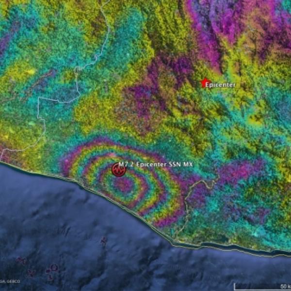
There are several ways to measure movement of the ground due to an earthquake. The Global Navigation Satellite Systems (GNSS) is a network of satellites providing positioning and timing to ground receivers, which provide a fairly precise measure of any movement. Additionally, Interferometric synthetic aperture radar (InSAR) combines images from two different dates, one before the event and one after the event, to assess the amount of deformation from ground movement, whether from a fault rupture or a volcanic bulge, collapse, or lava flow.

Global Navigation Satellite Systems (GNSS)

  • Discover GNSS Data in Earthdata Search
  • GNSS Data at NASA's Crustal Dynamics Data Information System (CDDIS)

Synthetic Aperture Radar (SAR)

  • Discover SAR Data with Earthdata Search
  • SAR Data at NASA's Alaska Satellite Facility DAAC (ASF DAAC)
  • Sentinel-1 InSAR Data at ASF DAAC
  • Uninhabited Aerial Vehicle SAR (UAVSAR) InSAR Data at ASF DAAC
  • UAVSAR KMZ Files at ASF DAAC

Webinars

  • Introduction to SAR
  • Applications of SAR Data in Geographic Information Systems (GIS) Environments

Data Tutorials/Recipes

  • What is SAR?
  • How to Find SAR Data
  • How to View SAR Data
  • How to use SAR Data (Recipes)

Emergency management personnel searching through rubble of earthquake-destroyed buildingDisaster Response

Many different types of NASA Earth observations can be used to provide disaster management personnel and first responders with relevant up-to-date data, often near real-time, to help in the management of recovery efforts.

Land Surface Reflectance

  • Discover Land Surface Reflectance Data in Earthdata Search
  • Visualize Land Surface Reflectance in NASA Worldview
  • Surface Reflectance Data at NASA's Land Processes DAAC (LP DAAC)

Land Surface Temperature

  • Discover Land Surface Temperature in Earthdata Search
  • Land Surface Temperature at LP DAAC

Active Fires and Thermal Anomalies

  • Discover Active Fire and Thermal Anomalies in Earthdata Search
  • Visualize Active Fire and Thermal Anomalies in NASA Worldview
  • Visualize Active Fire and Thermal Anomalies in the Fire Information for Resource Management System (FIRMS)
  • Active Fire and Thermal Anomalies at LP DAAC

Power Outages using Visible Infrared Imager Radiometer Suite (VIIRS) Day/Night Band

  • Discover VIIRS Day/Night Band in Earthdata Search
  • Visualize VIIRS Nighttime imagery in NASA Worldview
  • Black Marble at NASA's Level-1 and Atmosphere Archive and Distribution System DAAC (LAADS DAAC)
  • Black Marble Imagery in NASA Worldview

Webinars

  • Discover FIRMS
  • Introduction to Geospatial Analysis in R

Data Tutorials/Recipes

  • Getting Started with Moderate Resolution Imaging Spectroradiometer (MODIS) Thermal Anomalies and Fire Data: All About Accessing Data
  • Getting Started with MODIS Thermal Anomalies and Fire Data: Interpreting Quality Information
  • Getting Started with MODIS Thermal Anomalies and Fire Data: Using the Data
  • Learn about Satellite Detections of Fire in Worldview
  • Tutorials/Recipes for LP DAAC Data
  • Data Prep Scripts in R and Python at LP DAAC
  • Monitoring Volcanoes Using ASTER Satellite Imagery
  • 18 Years of Volcanic Eruptions: Mount Nyiragongo, Democratic Republic of the Congo

Getting Started

About the Data

NASA provides data from a variety of sources including satellites, airborne campaigns, field campaigns, in situ instruments and model outputs. NASA's Earth Observing System Data and Information System (EOSDIS) offers a wide variety of freely and openly available data that can be used to evaluate disaster-related events. 

Data User Profiles

Dr. Piyush Agram develops new techniques for using and interpreting SAR and Interferometric SAR (InSAR) imagery.

Brian Conway uses SAR data to monitor land subsidence and the impacts of this on Arizona's water resources.

Dr. Kristine Larsen researches plate tectonics and geodesy, with work developing new ways of using the Global Positioning System (GPS) to study Earth and the water cycle.

Dr. Rowena Lohman studies earthquake physics, satellite remote sensing, finite element modeling, ground displacements from a variety of anthropogenic and natural causes.
Dr. Mike Ramsey
 uses Earth science data to developing new ways to study active volcanoes and to provide data to support emergency response. 

Dr. Paul Siqueira works to improve SAR and other microwave sensors along with the Earth observing data they collect. 

Data Chats

Dr. Franz Meyer, Chief Scientist, Alaska Satellite Facility (ASF), talks about Synthetic Aperture Radar (SAR) 

Data Pathfinders

Earthquakes and Volcanoes Data Pathfinder
Disasters Data Pathfinder 

Feature Articles

Read about how researchers are using NASA satellite, field campaign, and model data to study natural disasters, the impacts of these disasters, and ways to mitigate risk and exposure. 

Other Resources

  • SAR Data from SARViews
    Earthquake-related Data from GeoGateway
    NASA Applied Sciences Earthquakes
    Volcano Data from the ASTER Volcano Archive
    Volcano Data in Action from LP DAAC
    Volcanological Applications of ECOSTRESS Data
    Volcano Data Stories at GES DISC
    NASA Applied Sciences Volcanoes


Updated January 11, 2021

Links

  • Screenshot of Earthdata Search showing western US and precipitation data.
    Discover and Access NASA's Earth Science Data with Earthdata Search

  • Screenshot of Worldview showing daily accumulated precipitation from Integrated Multi-satellitE Retrievals for GPM (IMERG).
    Getting Started with NASA Worldview

  • High Aerosol Optical Depth over Northern India - feature grid
    Discover Earth Science Data Learning Resources at NASA Earthdata

Page Last Updated: Feb 9, 2021 at 9:29 AM EST

Related Articles

  • Getting Ready for NISAR - and for Managing Big Data using the Commercial Cloud
  • Not so big, not so hot: Yellowstone is a kind of tutorial for volcano monitoring
  • When the Earth moved Kashmir
  • Sensing Remote Volcanoes

Discover Data and Services

  • Earthdata Search
  • Dataset Directory GCMD
  • Data Tools

@NASAEarthdata

Loading Tweets by NASAEarthdata...

We're sorry. Our Twitter feed cannot load right now.

In the meantime, visit us below!

@NASAEarthdata

ABOUT

DATA

COLLABORATE

LEARN

USER RESOURCES

SUPPORT

NASA Links

  • NASA Official: Stephen Berrick
  • Web Privacy Policy
  • Data and Information Policy
  • Communications Policy
  • Freedom of Information Act
  • USA.gov
  • Sitemap