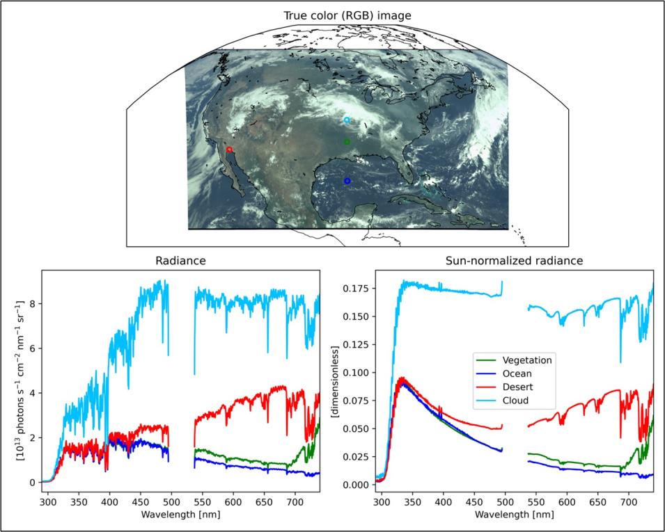
NASA's Atmospheric Science Data Center (ASDC) released a suite of beta Level 1 data products from the Tropospheric Emissions: Monitoring of POllution (TEMPO) mission.
Built by Ball Aerospace and launched into space aboard the Maxar Technologies Intelsat 40e satellite on April 7, 2023, the TEMPO instrument is an ultraviolet and visible spectrometer designed to observe the chemical components of the atmosphere over North America with more detail, precision, and timeliness than ever before. From its geostationary position 22,000 miles above Earth's equator, TEMPO provides hourly measurements of ozone, nitrogen dioxide, and other key elements of air pollution over its entire Field of Regard (or field of view)—from the Atlantic to the Pacific, and from the Yucatan Peninsula to the Canadian oil sands.
Among the products included in this release are:
- TEMPO Level 1B (Beta) Geolocated Earth Radiance (TEMPO_RAD_L1 V02): These Level 1 radiance files provide radiance information at TEMPO's native spatial resolution (~10 km2 at the center of the instrument's field of view) for individual granules; each granule covers the entire North-South TEMPO field of view, but only a portion of its East-West field of view.
- TEMPO Level 1B (Beta) Solar Irradiance (TEMPO_IRR_L1 V02), Available February 29, 2024: These Level 1 irradiance files provide solar irradiance measured using the working solar diffuser; each file includes the measured solar irradiance for all the North-South cross-track pixels
- TEMPO Level 1B (Beta) Solar Irradiance (TEMPO_IRRR_L1 V02), Available ~March 2024: These Level 1 reference irradiance files provide solar irradiance measured using the reference solar diffuser; each file includes the measured solar irradiance for all the North-South cross-track pixels
- TEMPO Level 1A (Beta) Dark Exposure (TEMPO_DRK_L1 V02): These Level 1 dark files provide the processed dark currents, corresponding to either solar irradiance measurements or radiance measurements; each file includes the measured dark currents for all the North-South cross-track pixels
All four data products are provided in netCDF4 format and are designated at a beta maturity level, which means the products are minimally validated and may contain errors. Users should refrain from making conclusive public statements regarding science and applications of these data products until a product is designated at the provisional validation status.
The Level 1 Geolocated Earth Radiance/Solar Irradiance products contain information on radiometrically and wavelength calibrated Earth radiance/solar irradiance for the ultraviolet (UV) and visible bands, corresponding noise, parameterized wavelength grid, viewing geometry, quality flags, and other ancillary information. The Level 1A Dark Exposure product contains information on dark current rates of all frames and their average for the UV and visible bands, pixel quality flags, and other ancillary information.
According to ASDC Science Lead Dr. Hazem Mahmoud, these Level 1 data—NASA's highest temporal resolution data collected from geostationary orbit—are a valuable resource for researchers around the globe and hold paramount significance for a variety of remote sensing applications.
“These Level 1 data are used in sophisticated algorithms and processing steps to convert geolocated TEMPO Level 1 data into meaningful geophysical parameters,” Mahmoud said. “These retrievals, also known as Level 2 data, are crucial for understanding our dynamically changing planet. The Level 2 data will contribute to environmental studies, climate research, disaster monitoring, and various applications requiring a deeper understanding of specific geophysical properties.”
