FIRMS Adds Ultra Real-Time Data from MODIS and VIIRS

Scientists develop routine service for wildfire detection in the continental United States with a latency of less than 60 seconds.
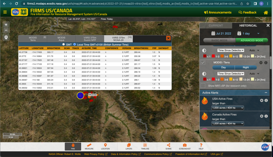
Screen capture of the Moose Fire in FIRMS showing URT data
Image Caption

This FIRMS US/Canada Fire Map image of the Moose fire in Idaho was acquired on July 21, 2022, at 5:40 a.m., EDT. With “Time Based” color coding of the fires, real-time (RT) and ultra real-time (URT) active fire data are indicated by dark red dots. Users can distinguish between URT and near real-time (NRT) data by clicking on an individual fire to view the attributes. Note: RT and URT data roll off the system after six hours as NRT data become available. Credit: FIRMS.

When it comes to monitoring and fighting wildfires, accurate and timely data about a fire’s location, extent, intensity, and impact are critical. That’s why NASA funded the Fire Information for Resource Management System (FIRMS) in 2007 and, more recently, partnered with the U.S. Forest Service to develop FIRMS US/Canada, a new instance of FIRMS that optimizes the Forest Service's distribution of active fire information by leveraging LANCE's web-based active fire mapping tools and capabilities for disseminating data, products, and services.

Now, FIRMS has announced the release of ultra real-time (URT) data, which provide active fire data in seconds and make FIRMS’s value to the wildland fire community even greater.

“[This] is the first routine service for detecting wildfires over the continental United States from NASA and NOAA low-Earth orbit satellites with a latency of less than 60 seconds from Earth observation to wildfire detection,” said Liam Gumley, a scientist with the Cooperative Institute for Meteorological Satellite Studies at the University of Wisconsin-Madison’s Space Science and Engineering Center (SSEC).

URT data are made possible by an SSEC-developed system that receives, decodes, and processes data from the Moderate Resolution Imaging Spectroradiometer (MODIS) aboard NASA’s Terra and Aqua satellites and the Visible Infrared Imaging Radiometer Suite (VIIRS) instrument aboard the joint NASA/NOAA Suomi National Polar-orbiting Partnership and NOAA-20 satellites to produce active fire data for the continental United States (CONUS) within 60 seconds using direct broadcast.

The system capitalizes on SSEC’s access to direct broadcast antennas throughout the continental United States, as well as Puerto Rico and Hawaii. Software systems enable the SSEC to stream the direct broadcast data in real-time from each antenna to a central collection point at the University of Wisconsin–Madison, which then ingests, merges, and de-duplicates the data in real-time. The software is set up to process micro-granules from Level 0 through Level 1 to active fire Level 2 products using the same version of the thermal anomalies/fire code (i.e., the contextual fire algorithm code) that LANCE uses. The active fire data are then converted to Comma Separated Values (CSV) format and provided to FIRMS via a web-based application programming interface (API). The result is MODIS wildfire detections with a latency of approximately 25 seconds and VIIRS wildfire detections with a latency of approximately 50 seconds (relative to time of observation on the spacecraft).
A direct broadcast antenna on the roof of Honolulu Community College in Honolulu, Hawaii.
Image Caption

The direct broadcast antenna on the roof of Honolulu Community College in Honolulu, Hawaii. This ground station is capable of receiving data from Earth observation satellites running on X and L band frequencies. Installed in 2012, this ground station acquires data from multiple satellites each day. Credit: SSEC.

According to Brad Quayle, a remote sensing and GIS specialist with the Forest Service's Geospatial Technology and Applications Center (GTAC), the fire data in FIRMS are being identified as URT so users can distinguish them from the near real-time MODIS and VIIRS data in FIRMS that are provided by the LANCE data stream.

NASA and the Forest Service have been planning for the implementation of real-time MODIS and VIIRS data into FIRMS applications, and both were impressed with the system the SSEC developed, so NASA began coordinating with the SSEC to incorporate the URT data into FIRMS. The initial funding for integrating the URT active fire data into FIRMS is from the NASA Applied Sciences Program Wildland Fires program area and the agency-wide FireSense initiative.

“The system significantly reduces the amount of time to process and access direct readout data compared to traditional processing workflow methods,” Quayle said. “The data are processed and available in seconds, as the satellite overpass is occurring, versus being available 15-20 minutes after the overpass has occurred.”

The ability to access such low-latency data is of immense value to the wildfire community.

“The more timely the data, the higher their value when assessing the location, extent, and intensity of newly detected fire activity,” said Quayle. “This timeliness also increases their potential for use as a tool to detect new fire starts. Having these data in FIRMS within a minute of a satellite overpass will help us identify where new starts may be occurring, particularly in remote, less populated areas.”

There are, however, some limitations with URT data, including the possibility of technical issues associated with the use of direct readout antennas.

“Terra’s direct broadcast signal uses the same frequency as the NASA Deep Space Network (DSN), so when the DSN is active out of Goldstone, California, the direct broadcast from Terra is temporarily halted for very short periods of time (typically less than a minute),” he said. “During those periods, no Terra MODIS direct readout data are received and there is a gap in the data for that very short period.”

There may also be occasional issues with particular ground stations that may happen to be temporarily offline due to technical issues, but such instances are “relatively rare,” said Quayle. Fortunately, ground station coverage typically overlaps, which helps minimize any potential data gaps. Further, any data gaps that might occur will be filled with NRT MODIS and VIIRS data from LANCE, albeit with a longer latency.

Quayle and Gumley also acknowledged that, although the MODIS and VIIRS instruments aboard Terra, Aqua, Suomi NPP, and NOAA-20 are well suited for detecting fires from low-Earth orbit, they may miss some ignitions given the infrequency of their observations. Active fire data from geostationary satellites could help fill that gap.

“There are tradeoffs between low-Earth orbit satellite observations versus geostationary observations,” said Gumley. “The low-Earth orbit sensors, such as VIIRS and MODIS, can detect smaller fires, but each satellite only flies over the CONUS 2 to 3 times in daylight and 2 to 3 times at night. Geostationary satellites provide CONUS data at 10-, 5-, or 1-minute intervals, so they can detect more wildfires. However, their ability to detect small wildfires is not as good as the sensors on the satellites in low-Earth orbit.”

Quayle concurs. “Geostationary satellite sensors, such as the Advanced Baseline Imager aboard NOAA’s GOES-16 satellite, can potentially provide more frequent updates on changes in fire spread and between low-Earth orbit observations, but at a coarser resolution and with other technical considerations,” he said.

NASA is already planning to add active fire data from geostationary satellites to FIRMS in the coming weeks.

As these continued improvements to FIRMS suggest, NASA and the Forest Service endeavor to establish a single, authoritative source of near real-time fire mapping, visualization, and geospatial data products for the United States and Canada. This enhanced cooperation will not only increase the fire community’s use of near real-time fire geospatial data products, it will expand NASA’s opportunity, under the auspices of LANCE, to evaluate and integrate additional sources of NASA, NOAA, and international space agency satellite data of value to the user community.

Notes:

For instruction on how to access URT data in FIRMS, see "Wildfire Detection in the US and Canada within a Minute of Satellite Observation."

In addition to URT MODIS and VIIRS data, the global and US/Canada instances of FIRMS recently added a Harmonized Landsat Sentinel-2 (HLS) short-wave infrared false color composite layer, which enables users to see surface features like active fire fronts and post-fire impacts. Learn more in the Earthdata article, “New HLS False Color Composite Layer Added to FIRMS.”

Details

Last Updated

Published