Principal Investigator (PI): Vardis Tsontos: NASA's Jet Propulsion Laboratory (JPL) Co-Investigators (Co-PI): Nga Quach, Charles Thompson, Flynn Platt, Joe Roberts, and Lewis McGibbney: JPL; Chi Hin Lam: Large Pelagics Research Center/University of Massachusetts, Boston; Sean Arms: Unidata/University Corporation for Atmospheric Research (UCAR)

Satellite Earth observations provide a wealth of information about our planet. While the data itself provides valuable information about the oceans, atmosphere and land, we can get an even better understanding of the Earth system and also improve the quality of the satellite data themselves when remote sensing data is combined with in-situ data field observations. These can range from physical and chemical observations to biological ones, such as species distribution data or crop records. However, the many types of in-situ data are collected and recorded in a variety of ways. As a result, in-situ data are characteristically heterogenous and complicated to handle since there is no standard metadata, file format, resolution or data type. This makes the integration of in-situ and satellite data particularly challenging.

The Oceanographic In-situ data Interoperability Project (OIIP) is a collaboration among JPL, UCAR/Unidata, and the Large Pelagics Research Center (LPRC) at the University of Massachusetts, Boston. The goal of the project is to address interoperability and data challenges associated with the integration of oceanographic in-situ datasets and satellite Earth observations using field campaign measurements and marine animal electronic tagging data as test cases.
OIIP interoperability in situ SST
Image Caption

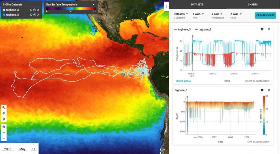
The integrated and interactive display of satellite Sea Surface Temperature (SST) and fish electronic tagging data via the OIIP web-based visualization tool. The track and plots shows the movement patterns and diving behavior of a Bigeye Tuna in the Eastern Tropical Pacific over a 4-year period in relation to a dynamic and spatially complex environment.

Project components include open source software tools for transforming in-situ data into netCDF files, as well as tools that allow for simultaneous visualization and processing of in-situ and satellite data.

  • OIIP Web-based Data Visualization Tool—This web-based tool allows for the integrated visualization of satellite and in-situ oceanographic data using JPL’s Common Mapping Client (CMC). CMC is a software framework and reusable set of components for efficiently developing and deploying Web-based mapping applications for the exposure of Earth science data. CMC capabilities were extended to access, integrate, and display in-situ and satellite-derived datasets, providing synchronized horizontal and vertical profile views of data and their evolution over time. Watch a video further explaining OIIP.
  • ROSETTA—The ROSETTA tool provides web-based capability for the conversion of in-situ data (unstructured columnar ASCII data) to Climate and Forecast (CF)/Attribute Convention for Dataset Discovery (ACDD) standards-compliant netCDF files. The GUI wizard guides the conversion and augmentation of file metadata by the user. Watch a video about ROSETTA.
  • THREDDS—Thematic Real-time Environmental Distributed Data Service (THREDDS) Web server technology provides metadata and data access for scientific datasets. Extensions added as part of OIIP will include support for point, profile, and trajectory spatial data types.
  • Tagbase – Tagbase is a relational database system designed to assist research teams manage their in-situ data collections by providing a comprehensive data model and multi-instrument manufacturer support. Watch a video on Tagbase.
  • CMC updates—JPL's CMC is a software framework and reusable set of components for efficiently developing and deploying Web-based mapping applications for the exposure of Earth science data. CMC capabilities were extended to access, integrate, and display in-situ and satellite-derived datasets, providing synchronized horizontal and vertical profile views of data and their evolution over time.
  • DMAS Enhancements and OIIP Integrated Workflow—The Data management and Archive System (DMAS) is an integrated set of software components that comprise NASA Physical Oceanography Distributed Active Archive Center’s (PO.DAAC) data archival and distribution architecture. OIIP extensions were added to DMAS to enable end-to-end workflow of all OIIP components. See a video of an end-to-end workflow of OIIP software components.

Overall, OIIP will improve PO.DAAC’s capacity to support NASA field campaign data via the integration of these technology components within system workflows with a view to operational DAAC infusion.

Read more about OIIP.

Publications:

Tsontos, V., Quach, N., Thompson, C., Platt, F., Roberts, J., Lam, C., and Arms, S. (2017). The oceanographic in situ data interoperability project (OIIP) - A year in review. In Oceans 2017 , Anchorage, AK, September 18-21.

Platt, F., Thompson, C. K., Roberts, J. T., Tsontos, V. M., Hin Lam, C., Arms, S. C., and Quach, N. (2017). Integrated Visualization of Multi-sensor Ocean Data across the Web. Abstract IN24A-05 presented at 2017 AGU Fall Meeting, New Orleans, LA, 11-15 Dec.