The ESA (European Space Agency) European Remote-Sensing Satellite (ERS) program was composed of two missions: ERS-1 and ERS-2. ERS was the first ESA Earth observation program to provide microwave spectrum-based environmental monitoring. Both satellites carried multiple instruments, including a synthetic aperture radar (SAR), designed to monitor the land, ocean, and atmosphere. At their time of launch the two ERS platforms were the most sophisticated Earth observation spacecraft ever developed and launched by Europe. 

Both ERS platforms were built with a core payload of two specialized radars and an infrared imaging sensor. The two were designed as identical twins with one important difference: ERS-2 included an extra instrument to monitor ozone levels in the atmosphere.

The ERS-1 mission ended in March 2000; ERS-2 was taken out of service in September 2011.

Type

SAR

Data Center

ASF DAAC

Launch

July 17, 1991

Objective

Multi-instrument observations of Earth's land and sea
ESA (European Space Agency)
NASA’s provision of the ESA (European Space Agency’s) European Remote Sensing satellites (ERS-1 and ERS–2) Synthetic Aperture Radar (SAR) data archive via NASA's Alaska Satellite Facility Distributed Active Archive Center (ASF DAAC) is free and open by agreement between NASA and ESA.

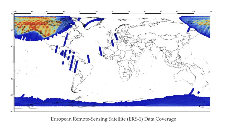
ERS-1 primarily collected high resolution imagery within the Alaska Satellate Facility (ASF) and the McMurdo, Antarctica, station masks. The datapool contains ASF standard beam odd frames, as well as the first and last frame of each imaged swath. ERS-1 flew in tandem with ERS-2 for 9 months in 1995/1996. Both sets of data are suitable for interferometry.

ERS-1 Dataset Summary

Dataset PropertyValue
Temporal Coverage1991 – 2000
Repeat Cycle35 days
Spatial CoveragePrimarily imagery within the ASF and the McMurdo, Antarctica, station masks
Center Frequency5.3 GHz/C-band 5.6 cm
PolarizationSingle Polarization (VV)
Spatial Resolution26 m in range (across track)
Between 6 m and 30 m in azimuth (along track)
Swath Width100 km
Off-Nadir Angle21°
Download infoData Discovery
File formatCEOS
ProviderESA
Date published:1991
Read more:Click to read more on the ESA website

Downloadable Products ERS-1:

Level 0 (unprocessed/raw data)

Level 1 (amplitude — processed images)

Global image with blue/yellow/red colors indicating swaths of ERS-1 data.
Image Caption

ERS-1 Level 1 data products are available over the regions colored in blue, green, yellow, and red.

ERS-1 carried the following instrumentation:

  • Synthetic aperture radar (SAR)
  • Wind scaterrometer
  • Radar altimeter
  • Along-track scanning radiometer
  • Microwave sounder
  • Precise Range and Range-Rate Equipment (PRARE)
  • Retroreflector array

The ERS-1/ERS-2 SAR operated in parallel with the Wind Scatterometer (WS) instrument. Together the SAR/WS configuration was called the Active Microwave Instrument (AMI). AMI had three modes of operation, which allowed the instruments to acquire images of land during day or night or through clouds. All products are provided in Envisat product format generated by the ESA ERS PF-SAR processor.

ERS-1/2 SAR Raw Image Product Level 0

Product characteristics:

  • Scene area: 100 km (range - across track) x full segment length (azimuth - along track)
  • Scene size: 5616 samples (range) x full segment length (azimuth)
  • Pixel depth: 10 bits signed integer (5 bits I, 5 bits Q)
  • Projection: Slant range

ESA ERS-1 End User License Agreement

Data provided by the ERS-1 and ERS-2 missions are available in an open and non-discriminatory way, and distribution of the data shall be consistent with United Nations Resolution A/RES/41/65 dated 3 December 1986 on Principles Relating to Remote Sensing of the Earth from Space.

ESA does not guarantee the suitability of ERS-1 or ERS-2 data for the purpose of a project and shall not be held liable for any damage derived from the use of such data by the user.

The acceptance of these Terms and Conditions will authorize full access using the ASF DAAC Vertex search portal to the ERS-1 and ERS-2 datasets at ASF DAAC.

I acknowledge and agree to respect the full title and ownership by ESA of all ERS-1 and ERS-2 data.

I agree to clearly mark all ERS-1 and ERS-2 data, irrespective of the form in which it is reproduced, in such a way that the data credit or image copyright are clear to see.

Data: Dataset: ERS-2[1], ESA [year of data acquisition]. Downloaded from ASF DAAC [day/month/year of data access].

Images: © ESA [year of data acquisition]

How to Cite ERS-1 Data

Dataset ProductHow to CiteFormatExample
ERS 1 DataCite data in publications such as journal papers, articles, presentations, posters, and websites. Please send copies of, or links to, published works citing data, imagery, or tools accessed through NASA's ASF DAAC to uso@asf.alaska.edu with “New Publication” on subject line.Dataset: ERS-2, ESA [year of data acquisition]. Retrieved from NASA's ASF DAAC [day month year of data access].Dataset: ERS-2, ESA 1993. Retrieved from NASA's ASF DAAC December 7, 2014.
ERS 1 ImageryInclude credit with each image shown in publications such as journal papers, articles, presentations, posters, and websites.© ESA [year of data acquisition]© ESA 1993

Related Platforms

Frequently Asked Questions

Earthdata Forum

Our online forum provides a space for users to browse thousands of FAQs about research needs, data, and data applications. You can also submit new questions for our experts to answer.

Submit Questions to Earthdata Forumand View Expert Responses

Earthdata
Forum