Description
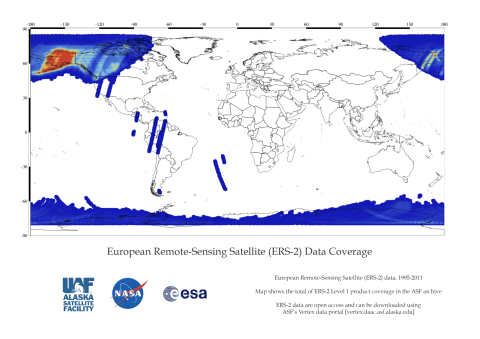
NASA’s provision of the European Space Agency’s (ESA) European Remote Sensing satellites (ERS-1 and ERS–2) Synthetic Aperture Radar (SAR) data archive via the ASF DAAC is free and open by agreement between NASA and ESA. As part of the Earth Observation Heritage Data Program (LTDP+), the ERS-1 and -2 missions provide scientists with historically accurate and easily accessible information to help further understand the dynamics of our planet.
ASF holds a subset of all ERS data.
Overview
ERS-1 and ERS-2 primarily collected high-resolution imagery within the ASF and the McMurdo, Antarctica, station masks. The datapool contains ASF standard beam odd frames, as well as the first and last frames of each imaged swath. ERS 2 flew in tandem with ERS-1 for 9 months in 1995/1996. Both sets of data are suitable for interferometry.
ERS-2 Dataset Summary
| Dataset Property | Value |
|---|---|
| Temporal Coverage | 1995 - 2011 |
| Repeat Cycle | 35 days |
| Spatial Coverage | Primarily imagery within the ASF and the McMurdo, Antarctica station masks |
| Center Frequency | 5.3 GHz/C-band 5.6 cm |
| Polarization | Single Polarization (VV) |
| Spatial Resolution | 26 m in range (across track) Between 6 m and 30 m in azimuth (along track) |
| Swath Width | 100 km |
| Off-Nadir Angle | 21° |
| File format | CEOS |
| Provider | ESA |
| Date published: | 1995 |
ERS-2 Mission phases
ERS-2 had one multi-disciplinary phase planned, but in early 2011, ESA changed the satellite orbit so SAR images of the Antarctic could be recorded with the same viewing angle every three days rather than every 35 days. For more information on the phase, see the Delft University of Technology website, which retrieved the information originally from ESA/ESRIN:
- ERS-2, 29-April-96 to 5-Sept-2011
Product Summary

Citation
Citation is critically important for dataset documentation and discovery. This dataset is openly shared, without restriction, in accordance with the EOSDIS Data Use Policy.
Maps
