Description
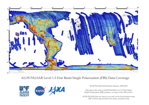
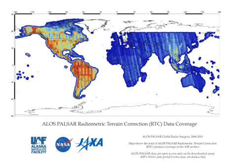
From 2006 to 2011, PALSAR’s L-band synthetic aperture radar (SAR) yielded detailed, all-weather, day-and-night observation, as well as repeat-pass interferometry. PALSAR data are from multiple observation modes with variable polarization, resolution, swath width, and off-nadir angle. PALSAR was one of three instruments on the Advanced Land Observing Satellite (ALOS), also known as DAICHI, developed to contribute to the fields of mapping, precise regional land-coverage observation, disaster monitoring, and resource surveying. ALOS was a mission of the Japan Aerospace Exploration Agency (JAXA).
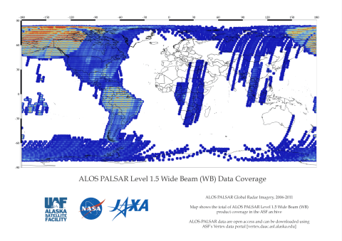
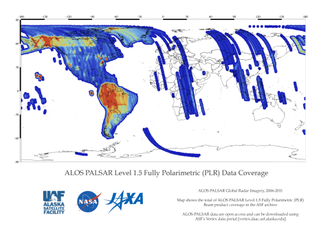
(PLR). ScanSAR wide beam (WB1, WB2) operates with a considerable loss of resolution. See table below.
Dataset Property | Fine Resolution | Fine Resolution, additional | ScanSAR | Polarimetric |
|---|---|---|---|---|
| Temporal Coverage | 2006-2011 | 2006-2011 | 2006-2011 | 2006-2011 |
| Repeat Cycle | 46 days | 46 days | 46 days | 46 days |
| Spatial Coverage | North, Central, and South America – Complete Outside the Americas – Partial | North, Central, and South America – Complete Outside the Americas – Partial | North, Central, and South America – Complete Outside the Americas – Partial | North, Central, and South America – Complete Outside the Americas – Partial |
| Beam Mode | FBS, DSN | FBD | WB1, WB2 | PLR |
| Center Frequency | L-Band (1.27 GHz) | L-Band (1.27 GHz) | L-Band (1.27 GHz) | L-Band (1.27 GHz) |
| Polarization | HH or VV | HH+HV or VV+VH | HH or VV | HH+HV or VV+VH |
| Spatial Resolution | 10 m | 20 m | 100 m | 30 m |
| Swath Width | 70 km | 70 km | 250-350 km | 30 km |
| Off-Nadir Angle | 34.3° (default) | 34.3° (default) | 27.1°(default) | 21.5° (default) |
| License | See License and Data Citation tab | See License and Data Citation tab | See License and Data Citation tab | See License and Data Citation tab |
| Download info | Data Discovery | Data Discovery | Data Discovery | Data Discovery |
| File format | L1.0,L1.1,L1.5,L2.2, RTC_LOW_RES, RTC_HI_RES,KMZ | L1.0,L1.1,L1.5,L2.2, RTC_LOW_RES, RTC_HI_RES,KMZ | L1.0,L1.1,L1.5,L2.2, RTC_LOW_RES, RTC_HI_RES,KMZ | L1.0,L1.1,L1.5,L2.2, RTC_LOW_RES, RTC_HI_RES,KMZ |
| Provider | Japan Aerospace Exploration Agency (JAXA). | Japan Aerospace Exploration Agency (JAXA). | Japan Aerospace Exploration Agency (JAXA). | Japan Aerospace Exploration Agency (JAXA). |
| Date published: | 2006-2011 | 2006-2011 | 2006-2011 | 2006-2011 |
| Read more: | ALOS-PALSAR on the JAXA Website |
PALSAR cannot observe the areas beyond 87.8 degrees north latitude and 75.9 degrees south latitude when the off-nadir angle is 41.5 degrees. Read more on the JAXA website.
Product Summary
Citation
Citation is critically important for dataset documentation and discovery. This dataset is openly shared, without restriction, in accordance with the EOSDIS Data Use Policy.
Data Center Citation
ALOS PALSAR - Crediting Data or Imagery
Credit use of data in publications such as journal papers, articles, presentations, posters, and websites. Include the DOI when available (each RTC ALOS PALSAR dataset processed by ASF has an assigned DOI).
| Data Type | Format | Example |
|---|---|---|
| ALOS PALSAR L1.0 or L1.5 | Dataset: ©JAXA/METI ALOS PALSAR [dataset name] [year of data acquisition]. Accessed through ASF DAAC, [link to website or insert comma and spell out in print: https://asf.alaska.edu] [day/month/year of data access] | Dataset: ©JAXA/METI ALOS PALSAR L1.0 2007. Accessed through ASF DAAC 11 June 2015. |
ALOS PALSAR – Crediting Imagery
Include appropriate credit with each image used in publications such as journal papers, articles, presentations, posters, and websites.
| Data Type | Format | Example |
|---|---|---|
| Primary or Derived Imagery | ©JAXA/METI [year of data acquisition] | ©JAXA/METI 2007. |
| Value Added Imagery | [creator credit, year created]; Includes Material – ©JAXA/METI [year of data acquisition] | ASF DAAC 2014; Includes Material ©JAXA/METI 2007. |
Maps


