Delivery of Suomi National Polar-orbiting Partnership (Suomi NPP) satellite data products will cease on November 1, 2026. Data users should transition now to alternative products from NOAA-21 and NOAA-20.
Suomi NPP data announcement
Telegraph and Mescal Fires, Arizona
Image captured on 5 June 2021, by the VIIRS instrument, aboard the joint NASA/NOAA Suomi NPP satellite.
Image
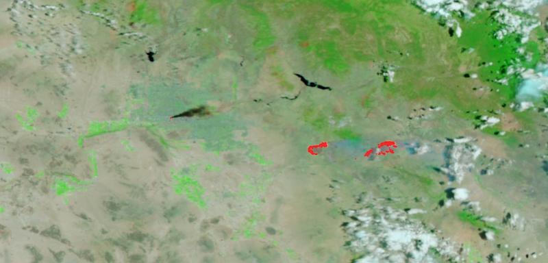
False-color (Bands M11-I2-I1) image of the Telegraph and Mescal Fires in Arizona. This image was acquired by the Visible Infrared Imaging Radiometer Suite (VIIRS), aboard the joint NASA/NOAA Suomi National Polar orbiting Partnership (Suomi NPP) satellite. Fires are shown as red points overlaid on the image.
The wildfires are burning in Arizona's south-central hill country, to the east of Phoenix. Telegraph Fire is in the center of the image, and the Mescal Fire is to the right of it. Also visible in the imagery, to the left of the Telegraph Fire, is black smoke emanating from a fire in a recycling yard in Phoenix. This fire burned 20-foot stacks of compacted cardboard and paper bails as well as spreading to a tire shop and lumber yard.
Visit Worldview to visualize near real-time imagery from NASA's EOSDIS, and check out more Worldview weekly images in our archive.
Details
Last Updated
Published on
June 14, 2021