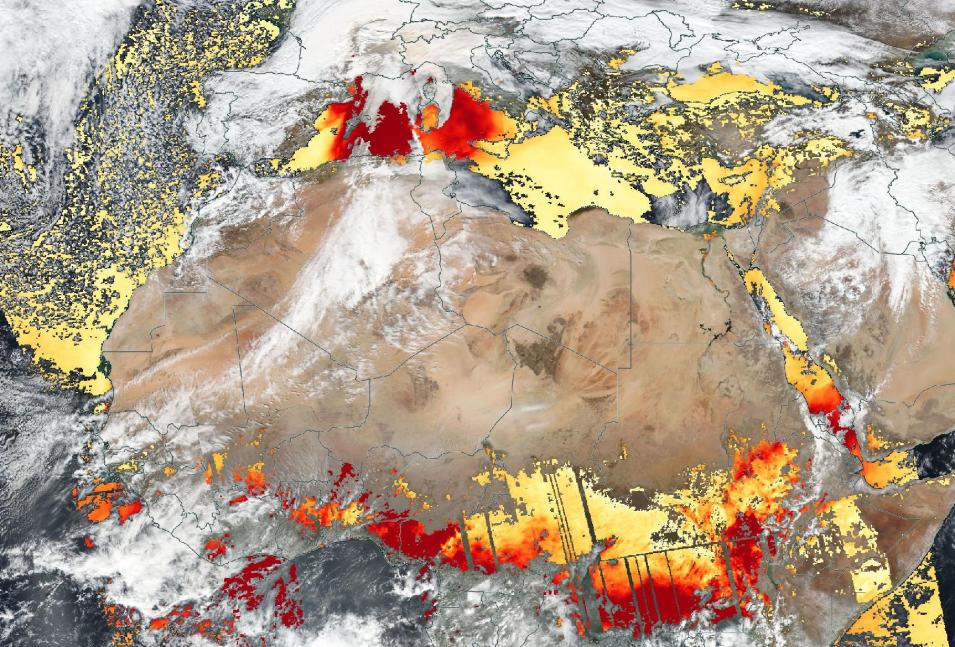
Given that radiometers, such as the Moderate Resolution Imaging Spectroradiometer (MODIS) aboard NASA’s Aqua and Terra satellites, and the Visible Infrared Imaging Radiometer Suite (VIIRS) aboard the joint NASA/NOAA Suomi National Polar-orbiting Partnership (Suomi NPP) and NOAA-20 satellites, can measure the light aerosols dispersed within a column of air, their data are a key source of information used in the data products that provide measurements of AOD.
Now, a new VIIRS Level-2 Dark Target Aerosol Optical Depth Near Real-Time (NRT) product (AERDT_L2_VIIRS_SNPP_NRT) has been made available from NASA’s Land, Atmosphere Near real-time Capability for EOS (LANCE). This product provides satellite-derived measurements of AOD and aerosol properties over land and ocean and is generally available within three hours of observation. It also includes measurements of AOD at other visible and near-IR wavelengths and derived parameters such as the Ångström exponent, which provides additional information related to the aerosol particle size over the ocean. With this parameter, the larger the exponent, the smaller the particle size. Therefore, values greater than 1 suggest optical dominance of coarse particles (e.g., dust), whereas values less than 1 suggest optical dominance of fine particles (e.g., smoke). The VIIRS Dark Target aerosol product is based on the same Dark Target algorithm developed for similar AOD products from MODIS and will ensure the long-term continuation of the climate data records.
The words “dark target” in the product’s title refer to the Dark Target algorithm that helps satellite data analysts detect bright aerosols over dark surfaces. In fact, there are two Dark Target algorithms in use, one of which is used over land and the other over the ocean. This dual approach results from the inherent difficulty of separating atmospheric aerosol and surface signals. The surfaces of dark-colored landscapes vary, due to vegetation, soil type, and topography and this can make it challenging to distinguish aerosols from the land beneath them. Over the ocean, where the surface is less diverse, this separation is much easier, allowing analysts to derive more information about aerosol properties.
The VIIRS Level-2 Dark Target Aerosol Optical Depth Near Real-Time (NRT) product is distinct from the VIIRS Deep Blue aerosol product, which uses the Deep Blue (DB) algorithm over land and the Satellite Ocean Aerosol Retrieval (SOAR) algorithm over water to determine aerosol loading for daytime cloud-free snow-free scenes. In addition, the new NRT Dark Target VIIRS product also differs slightly from the standard Dark Target VIIRS product in that it uses different sources of supplemental weather data. The near real-time version of the product uses ancillary data from the 12-hour Global Forecast System numerical weather model for surface windspeed, which is used to estimate the reflectance over the ocean surface, and for ozone and water vapor, which is used to isolate the aerosol signal from that of gases in the atmosphere. In the standard product these weather parameters come from the Global Ocean Data Assimilation System reanalysis.
The new Dark Target Aerosol Optical Depth product was developed by the Dark Target team at NASA’s Goddard Space Flight Center in association with NASA’s VIIRS Atmosphere Science Investigator-led Processing System (Atmosphere SIPS), located at the Space Science and Engineering Center (SSEC) at the University of Wisconsin-Madison. The VIIRS Atmosphere SIPS is responsible for processing, reprocessing, and general assessments of Suomi NPP VIIRS Atmosphere products.
LANCE is part of NASA’s Earth Observing System Data and Information System (EOSDIS), and distributes NRT data products from almost a dozen satellite-borne instruments. EOSDIS provides end-to-end capabilities for managing NASA’s Earth science data. These data represent some of the most complex and diverse Earth science data sets on the planet from satellites, aircraft, field measurements, and numerous other EOSDIS programs. The primary services provided by EOSDIS are data archive, management, and distribution; information management; product generation; and user support services. These services are managed by NASA’s Earth Science Data and Information System (ESDIS) Project.
For More Information
To download the VIIRS Level-2 Dark Target Aerosol Optical Depth Near Real-Time (NRT) data, or to discover and access other NASA NRT data, visit the EOSDIS LANCE website.
View the VIIRS Level-2 Dark Target Aerosol Optical Depth NRT product and the VIIRS Dark Target Aerosol Angstrom Exponent as layers in Worldview.
Learn more about VIIRS Deep Blue Aerosol and Dark Target Aerosol products at NASA's Level-1 and Atmosphere Archive and Distribution System Distributed Active Archive Center (LAADS DAAC).
Additional Reading
Sawyer V, Levy RC, Mattoo S, Cureton G, Shi Y, Remer LA. Continuing the MODIS Dark Target Aerosol Time Series with VIIRS. Remote Sensing. 2020; 12(2):308. doi:10.3390/rs12020308
