NASA will undertake six activities to meet the Earth observation satellite needs of U.S. Federal civilian agencies. These needs were identified through the 2022 Satellite Needs Working Group (SNWG) biennial survey of Federal agencies and represent high-profile needs for satellite Earth observation data. The SNWG is an initiative of the U.S. Group on Earth Observations (USGEO), which helps coordinate U.S. civilian satellite Earth observations. The SNWG Management Office (SNWG MO) at NASA's Interagency Implementation and Advanced Concepts Team (IMPACT) will oversee these activities.
NASA Identifies Activities to Address U.S. Satellite Observation Needs
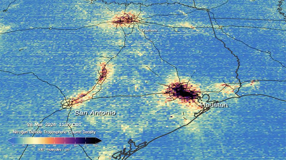
One identified Earth observation satellite need is for better assessment of atmospheric trace gases. This image from NASA's Tropospheric Emissions: Monitoring of Pollution (TEMPO) mission shows elevated nitrogen dioxide levels along major traffic corridors in Texas, with darker colors indicating higher concentrations. Following the 2022 SNWG Assessment, NASA is producing additional TEMPO-derived products to enable real-time monitoring of volcanic plumes and support air quality forecasting, modeling, and regulation. Credit: Trent Schindler/NASA's Scientific Visualization Studio.
Activities Identified in the 2022 SNWG Assessment
- Land surface elevation changes across the U.S. cause billions of dollars in damage every year associated with landslides, coastal subsidence, fluid extraction/injection, climate change, and other geohazards. Identifying and tracking land surface elevation change is needed nationally for separating coastal subsidence and sea level rise impacts, hazard mitigation, and infrastructure stability/fragility assessment and modernization.
NASA will generate a suite of products that track the magnitude of vertical land surface motions from the Sentinel-1 and joint NASA/ISRO (Indian Space Research Organisation) Synthetic Aperture Radar (NISAR; scheduled for launch in 2025) satellites.
- An outcome of NASA's 2016 SNWG Assessment was the production of a global Harmonized Landsat and Sentinel-2 (HLS) surface reflectance product, which is currently operational and is widely used among Federal agencies and the scientific community. The 2022 SNWG Assessment identified that a low-latency version of HLS, available publicly within six hours of data acquisition, will enhance the ability of agencies to respond to wildfires, earthquakes, droughts, oil spills, and other natural hazards.
- The launch of NASA's Tropospheric Emissions: Monitoring of Pollution (TEMPO) satellite in 2023 provides key measurements of trace gas constituents over North America from a geostationary orbit. In response to agency needs from the 2020 SNWG Assessment, NASA is currently developing a suite of trace gas products derived from TEMPO that will be available in real-time.
Following the 2022 SNWG Assessment, NASA will produce additional TEMPO-derived products that will enable real-time monitoring of volcanic plumes as well as science-quality aerosol and trace gas products to support air quality forecasting, modeling, and regulation.
- As a result of agency needs evaluated during the 2022 SNWG Assessment, NASA will provide targeted training to agency data users in the use of satellite data to inform their decision-making process.
- Observations of ocean surface winds are vital for facilitating marine navigation, predicting hurricanes and other oceanic storms, and modeling the ocean-atmosphere interface, and are of increasing importance for offshore wind energy applications.
NASA will combine wind retrievals from a variety of satellite sensors to provide observations of near-surface winds over the data-sparse global ocean at roughly six-hour intervals, providing key inputs to atmospheric and oceanic general circulation models.
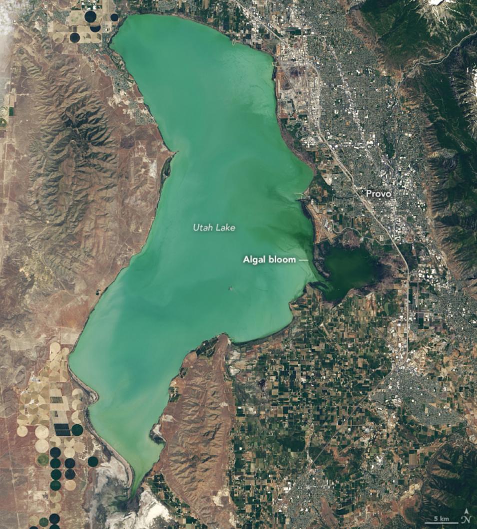
- Harmful algal blooms (HABs) are a direct threat to environmental and public health. Mitigation and avoidance of HABs require information on the location and extent of these blooms at high temporal resolution. This monitoring is possible due to the unique spectral signatures of algal blooms, which can be measured remotely by instruments aboard satellites.
NASA will implement an automated product to show the presence of HABs in global regions that are vulnerable to such blooms. This activity will build on the current Cyanobacteria Assessment Network (CyAN), which monitors algal blooms in lakes across the continental U.S. and Alaska. CyAN is led by the U.S. Environmental Protection Agency and includes NASA, NOAA, and the USGS.
An image of Utah Lake near Provo, UT, captured by the Operational Land Imager (OLI) instrument aboard the joint NASA/USGS Landsat 8 satellite on June 20, 2017. The darker green area on the right near the city of Provo shows where a large algal bloom is concentrated. Credits: NASA Earth Observatory image by Lauren Dauphin using Landsat data from the USGS and data courtesy of Blake Schaeffer/EPA.
Next Steps
To drive toward greater societal impact, SNWG agencies will be invited to co-design these solutions with NASA to help ensure that they are usable, accessible, and actionable upon completion. This process will be coordinated through the Stakeholder Engagement Program of the SNWG MO, which brings together capabilities from across NASA and other partner organizations to assist with SNWG solution co-development/implementation, training, and outreach.
The 2022 Assessment also identified several activities relating to commercial data access that would enable agencies to better carry out their high-priority objectives. NASA's Commercial SmallSat Data Acquisition program (CSDA) is currently evaluating these recommendations.
For more information and updates on past activities undertaken by NASA to meet SNWG agency needs, visit the Earthdata SNWG solutions page.

