Trapping Tapirs

An endangered species emerges from the shadows.

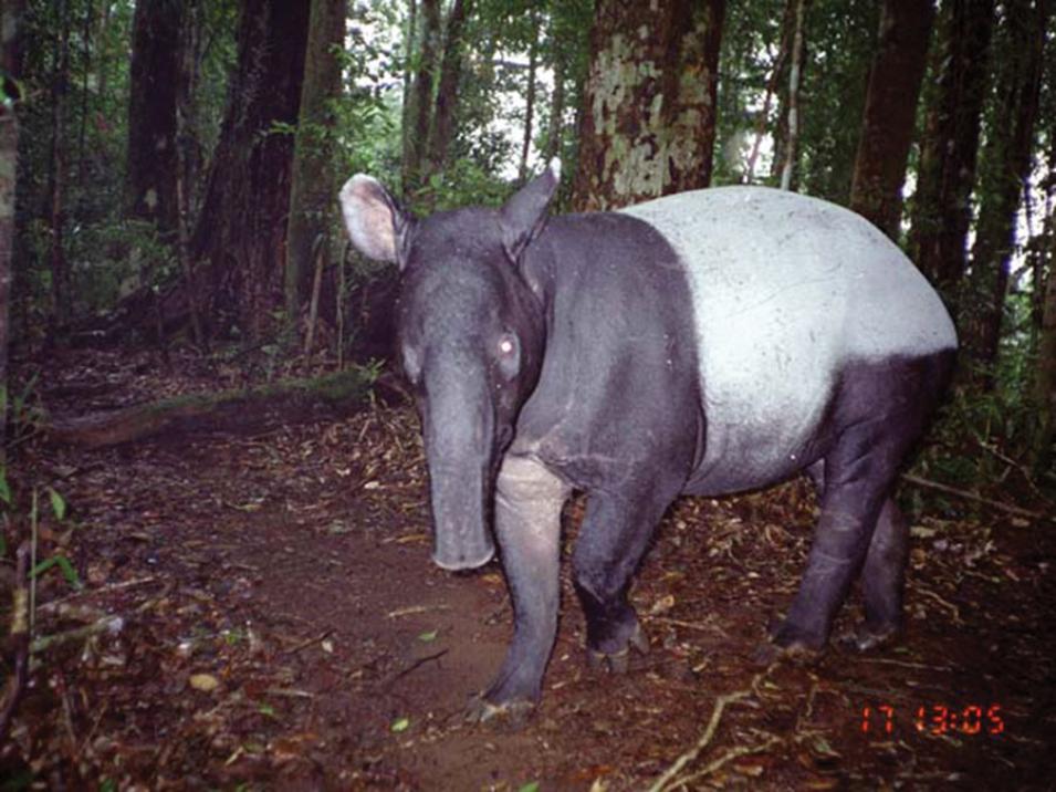
Tiger conservationist Matthew Linkie recalls the first and only time he’s seen a wild Malayan tapir. He and his field crew were packing up camp one morning when a guide started shouting. “There was this huge tapir, maybe twenty or thirty meters in front of us,” Linkie said. “You’re in this rainforest and the sun’s coming up and all these brilliant greens are coming through the forest. Then there’s this big black and white blob the size of a small car crossing the river. Absolutely incredible.” Linkie’s daylight sighting was rare: Malayan tapirs are reclusive, nocturnal creatures that prefer traversing the thick rainforest understory in darkness.

Their nocturnal roaming helps promote plant diversity because tapirs spread seeds as they eat, perpetuating a cycle that helps distribute plants and regenerate forests. But Malayan tapirs are endangered. And they have been very difficult for conservationists to monitor—that is, until Linkie noticed tapirs showing up in camera trap data. Motion-triggered cameras, strung throughout the rainforests of Southeast Asia, are designed to capture snapshots of any warm-bodied animal moving through the forest. Because tapirs shy away from human contact, Linkie wondered if these traps could help monitor them. Likewise, could he learn whether human activities disturb the tapir’s already dwindling habitat?

image
Image Caption

Malayan tapirs are primarily nocturnal, so camera traps usually catch them at night. Their unique black-and-white coloring helps camouflage them in darkness. (Courtesy M. Linkie, Fauna & Flora International)

Of tigers, traps, and tapirs

Related to the horse and rhinoceros, tapirs look like neither. Instead, they are somewhat pig-shaped and sport a long, flexible snout. “It’s a funny-looking animal but it’s a beautiful animal, as well,” said Linkie. Of the four tapir species, Malayan tapirs are the largest. What really sets them apart is their bold, panda-like coloring: black head and legs contrasted by a moon-white body and rump.

image
Image Caption

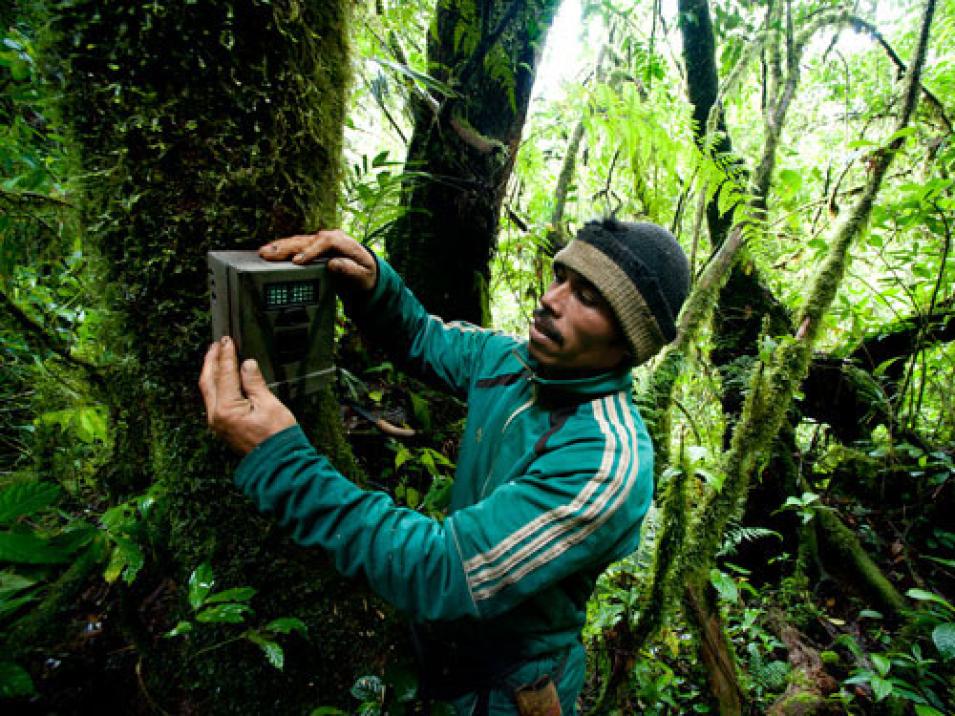
Researchers relied on 1,128 camera traps like these to gather photos of animals in the forests. Although most of the traps were set to catch tigers, they also caught tapirs and other animals that used the same trails. (Copyright J. Holden/ Fauna & Flora International)

Initially, Linkie used camera traps to study tigers, since traps have proven efficient in thick jungle foliage. “The rainforest is really, really dense, so when you go walking through you can’t really deviate off the main trails,” Linkie said. “So a lot of these rainforest mammals, the large-bodied ones, tend to stick to the same trails.” Installing camera traps along these established trails enables researchers to remotely monitor a variety of species in ways that were not previously possible.

While scanning for tigers in trap photographs, Linkie realized traps could also track the somewhat neglected Malayan tapir. “In Latin America, tapirs are one of the best studied mammal species,” he said. In Asia, however, tapirs tend to be disregarded in favor of more charismatic animals such as rhinoceroses or elephants. “The Malayan tapir needs champions,” Linkie said.

In spite of their elusive nature, the tapir’s role in forest ecology is important. “They are very effective seed dispersers,” said Patrícia Medici, chair of the Tapir Specialist Group of the International Union for Conservation of Nature (IUCN). Malayan tapirs eat about 115 different species of fruits and plants. As they roam throughout their territory, they deposit the undigested seeds in their dung. “We know that the absence of tapirs has a huge impact on the diversity and structure of the forest,” Medici said.

Tracking tapir occupancy

Researchers have been using camera traps to track everything from tigers to poachers, so thousands of them are installed across Southeast Asia. Linkie and his thirty-six colleagues needed to narrow down the most likely sites. Since Malayan tapirs prefer the dense jungle understory, the researchers analyzed data from NASA's Space Shuttle Radar Topography (SSRT) Mission, revealing elevation and slope of the land. Other data were used to indicate forest and river edges. They also looked at forest fire data from the Moderate Resolution Imaging Spectroradiometer (MODIS) instrument that could serve as a proxy for deforestation to decide whether certain trap sites might hold tapirs.

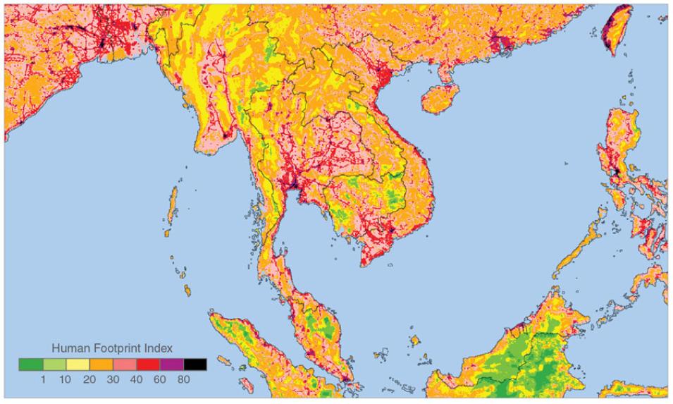
To map human activity, Linkie used the Human Footprint Index. Linkie had never used the index before, but it is well known within conservation circles, he said. Archived at NASA's Socioeconomic Data and Applications Center (SEDAC), the index features human population densities and elevations, land use, travel routes, villages, and coasts. The higher the index, the more human disturbance there is. “When you look at patterns of change around these landscapes,” Linkie said, “they all tend to emanate out of these areas with higher index, meaning areas that might be at lower elevation, might be closer to roads, or might be closer to villages.”

After choosing nineteen sites containing a total of 1,128 camera traps, Linkie looked for tapirs in photographs taken between 1997 and 2011. The sites spanned protected conservation parks and unprotected areas in Myanmar, Thailand, Malaysia, and the Indonesian island of Sumatra. It was impossible to tell whether the traps captured snapshots of different tapirs each time or the same tapir over and over. But what the photographs could show was overall tapir “occupancy,” revealing which areas tapirs occupied, and which they did not.
image
Image Caption

The Global Human Footprint index maps anthropogenic impacts on the environment on a scale of 0 to 100, with 0 representing the least influenced and 100 indicating the most influenced. Factors include population density, land use and infrastructure, nighttime lights, and access routes such as coastlines, roads, railroads, and rivers. Scientists often use these data for wildlife conservation planning and natural resource management. (Courtesy NASA Socioeconomic Data and Applications Center)

A new layer of data

Linkie found tapirs at 295 camera traps, which yielded a probability of occurrence of 0.43, meaning tapirs existed at 43 percent of the range-wide study area. He also discovered a relationship between occupancy and human impacts. Overall, tapirs were less likely to exist in areas with more human disturbance. In Myanmar, occupancy rates tended to be lower, because much of the land contains open mines or is illegally logged. Trap sites in Malaysia, Thailand, and Sumatra, however, revealed less human encroachment and more robust tapir populations.

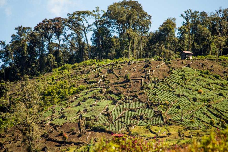
Yet even in some of the protected areas, logging and road building have destroyed or fragmented forests, isolating already small tapir populations. The skyrocketing demand for palm oil is devouring land in Malaysia and Sumatra. Oil palm plantations are replacing huge swaths of native vegetation, which further fragments forests. Malayan tapirs have few natural predators, so this fragmentation may be their biggest threat. Medici said, “They need the landscape between forest fragments to be permeable, so they can cross the landscape between forest fragments. Otherwise, these very, very small populations just don’t survive.” Roads, clear cuts, and plantations tend to create non-permeable landscapes that tapirs tend to avoid crossing, but permeable landscapes contain vegetation that tapirs are comfortable moving through, effectively bridging fragments.

For the first time, researchers have solid data about where the Malayan tapir currently exists and where human encroachment has already done the most damage. “Before the study, we had just a series of polygons on the map showing where people or experts saw tapirs, where tapirs occurred,” Linkie said. “Now we actually have another layer of data on a threatened species that you can take to government partners.” This information can help conservation groups identify priority areas for tapirs and guide decisions about where to focus future efforts.

image
Image Caption

Kerinci Seblat National Park in Sumatra, Indonesia, was one of the researcher’s tapir study areas. Even though it is protected, it is not immune to illegal logging. Forest fragmentation caused by logging threatens Malayan tapirs, shy animals that prefer the deep cover of forests. (Courtesy L. Mackin)

A conservation bright spot

The tapir’s very ordinariness is part of its saving grace. “Tapirs are not valued in traditional medicine, so that affords them an extra level of protection,” Linkie said. And unlike tapirs in Latin America, Malayan tapirs are rarely hunted for their meat. “Hunters in Sumatra or Malaysia say the meat tastes really bad,” he said. In addition, most of Sumatra’s population follows Islam, which prohibits eating pig. “When it comes to tapir, many people are not quite sure what a tapir is, whether it’s a pig or a horse,” Linkie said. “So people generally tend to leave it alone because of that.”

Linkie’s research emphasized how and where the Malayan tapir may be most threatened right now, but also revealed a bright spot for its future. Given the land use changes across Southeast Asia over the past few decades, especially with the surging appetite for palm oil, Linkie did not expect to find tapirs in so many places. “Yet tapir occupancy is still quite high in a lot of these areas. That was the encouraging message from our study.” By combining human activity with terrain to locate suitable camera trap sites, Linkie demonstrated that researchers can now keep tabs on what used to be an elusive animal.

References

García, M. J., E. P. Medici, E. J. Naranjo, W. Novarina, and R. S. Leonardo. 2012. Distribution, habitat and adaptability of the genus Tapirus. Integrative Zoology 7(4): 346–355, doi:10.1111/j.1749-4877.2012.00317.x.

Linkie, M., G. Guillera-Arroita, J. Smith, et al. 2013. Cryptic mammals caught on camera: Assessing the utility of range wide camera trap data for conserving the endangered Asian tapir. Biological Conservation 162: 107–115, doi:10.1016/j.biocon.2013.03.028.

NASA Land Processes Distributed Active Archive Center (LP DAAC). Burned Area Monthly L3 Global 500m. USGS/Earth Resources Observation and Science (EROS) Center, Sioux Falls, SD, doi:10.5067/MODIS/MCD45A1.006.

NASA Land Processes Distributed Active Archive Center (LP DAAC). NASA SRTM Products. USGS/Earth Resources Observation and Science (EROS) Center, Sioux Falls, SD.

Sanderson, E. W., M. Jaiteh, M. A. Levy, K. H. Redford, A. V. Wannebo, and G. Woolmer. 2002. The human footprint and the last of the wild. Bioscience 52(10): 891–904, doi:10.1641/0006-3568(2002)052[0891:THFATL]2.0.CO;2.

Wildlife Conservation Society - WCS, and Center for International Earth Science Information Network (CIESIN) - Columbia University. 2005. Last of the Wild Project, Version 2, 2005 (LWP-2): Global Human Footprint Dataset (Geographic). Palisades, NY: NASA Socioeconomic Data and Applications Center (SEDAC). http://dx.doi.org/10.7927/H4M61H5F. http://sedac.ciesin.columbia.edu/data/set/wildareas-v2-human-footprint-geographic.

For more information

NASA Land Processes Distributed Active Archive Center (LP DAAC)

NASA Socioeconomic Data and Applications Center (SEDAC)

About the remote sensing data
Satellites Terra and Aqua
Sensors Shuttle Radar Topography Mission (SRTM) Moderate Resolution Imaging Spectroradiometer (MODIS)
Data sets Global Human Footprint (Geographic). v2 (1995-2004)

SRTM Global 1 arc second

SRTM Global 3 arc seconds

Burned Area Monthly L3 Global 500m (MCD45A1)
Resolution 1 kilometer 1 and 3 arc seconds 500 meter
Parameters Human population, land cover, land use Elevation Fire and thermal anomalies
DAACs NASA Socioeconomic Data and Applications Center (SEDAC) NASA Land Processes Distributed Active Archive Center (LP DAAC) NASA LP DAAC

Details

Last Updated

Published

Data Center/Project

Land Processes DAAC (LP DAAC)
Socioeconomic Data and Applications Center (SEDAC)