Rubble Trouble

Laser tracking hones in on dangerous space debris.

Checking the weather, sending a text, or updating Facebook requires bouncing a signal between Earth and satellites. The remains of these communication satellites, along with sixty years of space activity, have littered outer space. An orchestra of objects swirls in various orbits: decommissioned satellites, burnt-out rocket stages, lost tools, and fragmented particles from explosions and collisions. When tiny flecks of paint travel with enough force to cut cables, damage space shuttle windows, or kill astronauts, accurately tracking debris matters.

About 500 miles above Earth’s atmosphere spins the defunct European Space Agency Environmental Satellite (Envisat). Weighing eight tons and large as a Greyhound bus, it is at high risk for collision. The Space Surveillance Network (SSN) operated by the U.S. Air Force routinely tracks debris in space, but Harald Wirnsberger and a team of researchers from the Austrian Academy of Sciences want to offer an alternative to monitoring space debris that is available to any nation. Their recent study, using multiple lasers to track Envisat, offers public alternatives to what is now mainly military-controlled information.

image
Image Caption

In this artist’s rendition, an in-orbit explosion occurs when residual fuel within a rocket stage or satellite tank self-ignites. These discarded objects can deteriorate over time in the extreme temperatures and harsh environment of space. Leaks mixing with fuel components trigger such explosions, scattering debris in many directions and at varying speeds. (Courtesy European Space Agency)

Soundless booms

More than 20,000 pieces of debris, softball sized and larger, orbit the Earth. About half a million pieces are marble sized. But millions of pieces are too small to track. “All these pieces are moving with high velocity in the range of 8 kilometers per second,” said Georg Kirchner, a member of Wirnsberger’s team. That is equivalent to 17,500 miles per hour, or ten times faster than a bullet.

“All these objects are in different orbits, mainly where they were launched,” Kirchner said. When objects in different orbits intersect, their collision, crashing at thousands of miles per hour, may lead to a domino effect referred to as the Kessler syndrome. Each collision increases the likelihood of future collisions. A 30 percent rise in space debris resulted from a Chinese anti-satellite test in 2007, and from the accidental collision of a defunct Russian satellite with a functioning U.S. commercial satellite in 2009. The two collisions added more than 5,000 pieces of traceable debris.

Most debris cycles in low-Earth orbit, between 100 to 1,250 miles above the planet. The SSN detects, tracks, and catalogs objects orbiting Earth. They predict when and where objects de-orbit, or re-enter the Earth’s atmosphere. They also distinguish between objects and missiles because radar by itself cannot. And they inform NASA of potential collisions with satellites or the International Space Station (ISS). From 1998 to 2012, the ISS performed fifteen evasive maneuvers. When space debris is identified too late for a maneuver, the station crew must evacuate, which has occurred three times since 2009.

image
Image Caption

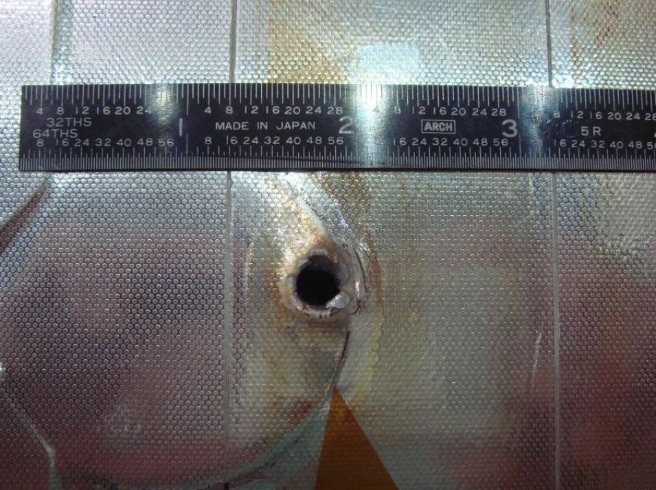
Orbiting debris hit Space Shuttle Endeavour’s radiator during one of its missions. The entry hole is about 6 millimeters (0.25 inches) across, and the exit hole is twice as large. (Courtesy NASA)

Currently, the SSN uses optical telescopes and ground-based radars that send microwaves into space. These methods, however, have an accuracy ranging from several hundreds of meters to a few kilometers. Satellite Laser Ranging (SLR) has proven to be an alternative to improve debris surveillance in the low-Earth orbit, shrinking accuracy to a few meters and even tenths of meters.

A ground network of fifty-two SLR stations around the world shoots short pulses of light at satellite reflectors to measure the time of round-trip flight. This provides instantaneous range measurements, precisely tracking satellite locations within millimeters. SLR has also supported research in geodesy, geophysics, lunar science, and fundamental constants. “Tracking debris without reflectors is a new field for laser ranging,” Wirnsberger said. “The intention is not to catalog space debris, but to refine predictions.” But arbitrarily pointing a laser into space is not efficient. First of all, if photons come back, it is not clear what they hit. To initially track a debris target, the team used orbital information provided by a coordination system called Two-Line Elements (TLE), created by the United States Air Force. Over 70,000 objects have been cataloged.

Cat eyes

“We had a target up there,” Kirchner added. Envisat was launched in 2002, carrying nine instruments to gather observations of Earth. It was meant to last five years, but outlived its projection by another five.

“The advantage of Two-Line Elements is that they are simple to use and available for most targets,” Kirchner said. They are accessible from the Internet. It allows researchers to pre-calculate where to expect an object. “But these publicly available predictions have an uncertainty in the range of kilometers,” Wirnsberger said.

image
Image Caption

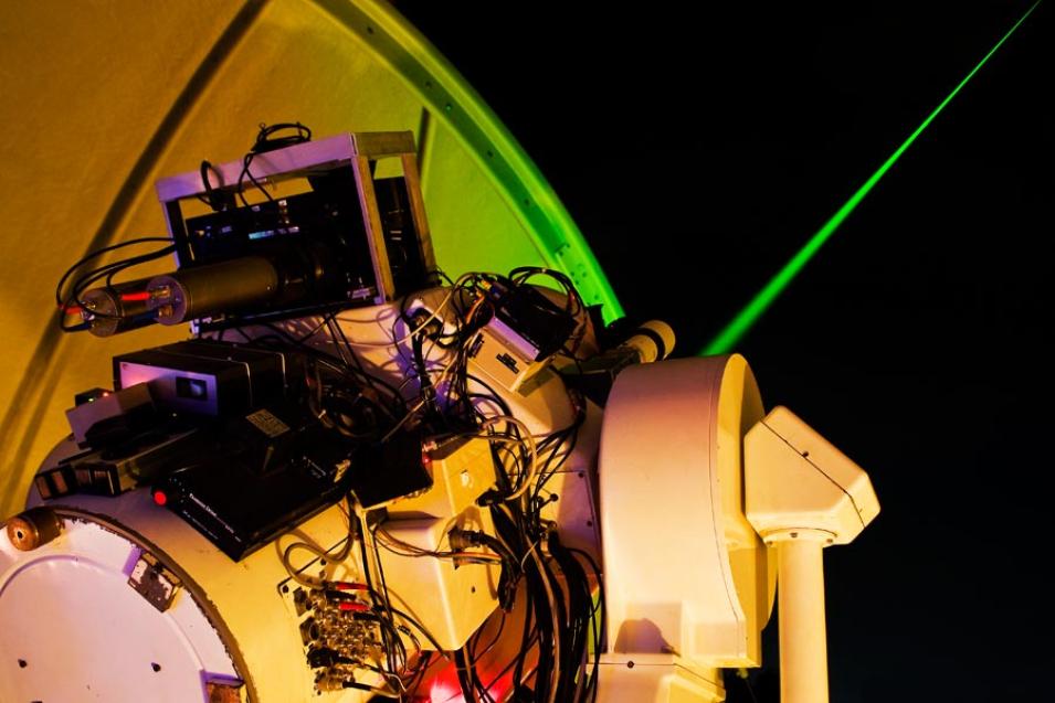
A Satellite Laser Ranging (SLR) Station at Graz observatory in Austria beams a laser into space, tracking the Environmental Satellite (Envisat). This SLR station acts as the active station, sending off photons, while nearby stations act as passive stations, receiving the Graz photons. (Courtesy H. Wirnsberger)

Two classes of objects orbit Earth: cooperative and uncooperative. Cooperative objects are equipped with retroreflectors, attached to satellites with the intention of being tracked. “Retroreflectors are similar to what we call cat eyes in German,” Kirchner said, “those things on the side of the street, reflecting light back in the same direction where light was coming.” Objects from collisions or lost items released by astronauts have no reflectors. They are uncooperative objects. To date, these have been the most difficult to track.

Envisat is equipped with retroreflectors, but the satellite has started spinning since it lost contact with Earth. It behaves like an uncooperative target. “An active satellite can correct its spin, but if it is no longer active then it often starts oscillating,” Kirchner said. Collisions will oscillate satellites. So will explosions. When fuel tanks deteriorate in the extreme temperatures of space, the residual fuel within may ignite and increase torque.

Most SLR stations are incapable of tracking objects without reflectors. When a laser beam hits an uncooperative object, photons reflect diffusely. Rather than a round trip shot, the photons spread out against the surface of the target, like marbles bouncing off of a toy school bus. Some of the photons will make their way back to give an estimate of distance based on time traveled. “But only three stations demonstrated this is possible,” Wirnsberger said. To extend the sparse network of SLR stations, the team increased the number of stations receiving photons, calling them passive stations.

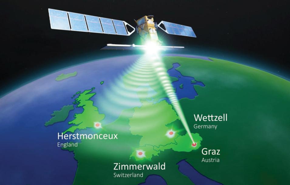
Knowing where to shoot, the active Graz station pointed up. Nearby stations in England, Switzerland, and Germany acted as passive stations, waiting for the return travel of the Graz photons. Time bias could throw everything off, however. So synchronization between participating stations was key.

Then, the researchers compared firing only the Graz laser and processing the single station round trip time of flight, and firing Graz but also incorporating multiple passive stations. “So with one shot we had two or more measurements,” Kirchner said. More measurements from different locations provided better orbit prediction. Using one passive station improved orbit predictions by a factor of ten. “Simple geometry helps with accuracy,” Kirchner said.

Laser ranging activities are organized under the International Laser Ranging Service (ILRS), which provides global satellite and lunar laser ranging data. The teams’ derived data are archived at NASA's Crustal Dynamics Data Information System (CDDIS), a NASA Distributed Active Archive Center (DAAC) and one of two data centers that support ILRS.

image
Image Caption

This illustration shows where diffuse photons were picked up by three other passive stations: Zimmerwald, Switzerland; Herstmonceux, England; and Wettzell, Germany. The Satellite Laser Ranging station at Graz, Austria, sent out the initial pulse, rendering it the active station. (Courtesy P. Ruzek, Astronomy Institute University Bern, Switzerland)

To move or not to move

Laser ranging works for debris at least 1 square meter (11 square feet) and no higher than 3,000 kilometers (1,900 miles) above Earth. So the most polluted orbits are within reach. “It is quite impressive to send photons out where there are no reflectors, only diffuse reflection, and detect it at a distant passive station. These data can be used to provide orbit predictions in a short period of time,” Wirnsberger said. “The concept is new and great.”

image
Image Caption

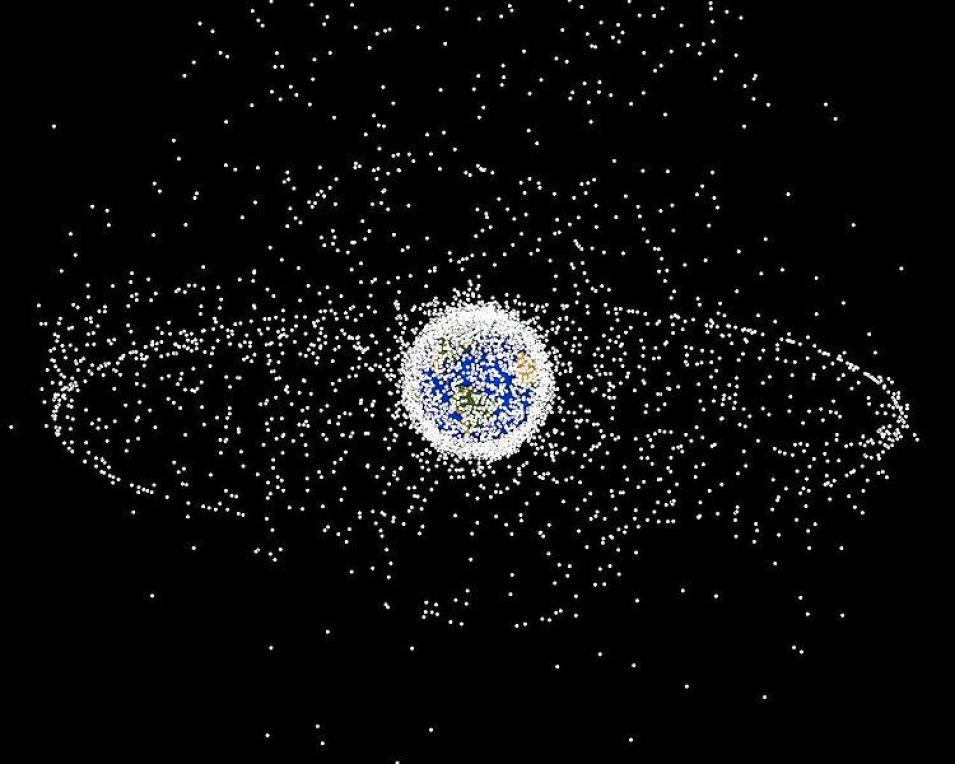
This illustration depicts space debris in low Earth orbit, the condensed region of white closest to Earth, and in geostationary orbit, farthest away at 35,786 kilometers (22,236 miles) above the Earth's equator. Communication and weather satellites extend to these outer reaches. Though the satellites in geostationary orbit are more stable than in low Earth orbit, they are also more permanent debris, only able to enter Earth’s orbit after millions of years. (Courtesy NASA)

The better the accuracy of orbit prediction, the better the decisions of how to function in space. Evasive maneuvers take energy. “Fuel is a main limitation for satellite lifespan,” Kirchner said. So if a satellite is predicted to come within 300 meters, give or take 500 meters, of a discarded rocket stage in five days, there is no certainty in the prediction. But with improved accuracy—a give or take of 100 meters—satellite operators may have confidence to avoid a maneuver.

With the growth in clutter, space exploration will be more costly and dangerous. Future generations will need to penetrate a layer of debris with more accuracy, planning for more fuel for evasive maneuvers and for more shields critical against small debris. Low-Earth orbit may even become impassable.

Given Envisat’s orbit and size, it will take about 150 years to gradually fall into Earth’s atmosphere. So it is a good candidate for removal from orbit. But how feasible is that? “The most progressive answer,” Kirchner said, “would be not yet. And the most hesitating answer would be never.” Spin is a big part of the challenge. To remove a satellite, something needs to be sent to attach to the target, and then together they would need to return. “You have to know how fast satellites are spinning if you want to remove them,” Wirnsberger said. The team is working on refining predictions to determine spin rate. Satellite Laser Ranging is proving to have more capabilities than initially anticipated. And with time, through cooperative knowledge, debris clean up may become more of a reality.

References

Kirchner, G., F. Koidl, F. Friederich, I. Buske, U. Völker, and W. Riede. 2013. Laser measurements to space debris from Graz SLR station. Advances in Space Research 51: 21–24, doi:10.1016/j.asr.2012.08.009.

NASA Crustal Dynamics Data Information System (CDDIS). Satellite Orbit Predictions. Greenbelt, MD, USA. http://cddis.gsfc.nasa.gov/Data_and_Derived_Products/SLR/Orbit_predictions.html.

Wirnsberger, H., O. Bauer, and G. Kirchner. 2015. Space debris orbit prediction errors using bi-static laser observations. Case study: ENVISAT. Advances in Space Research 55: 2,607–2,615, doi:10.1016/j.asr.2015.02.018.

For more information

NASA Crustal Dynamics Data Information System (CDDIS)

International Laser Ranging Service (ILRS)

Orbital debris information

Space debris information

About the remote sensing data
Sensor Satellite Laser Ranging stations
Data set Satellite Orbit Predictions
Spatial extent Bounding Rectangle: (90.0 degree, -180.0 degree, -90.0 degree, 180.0 degree)
Temporal resolution 1 day
Parameter Orbit predictions
DAAC NASA Crustal Dynamics Data Information System (CDDIS)

Details

Last Updated

Published

Data Center/Project

Crustal Dynamics Data Information System (CDDIS)