ORNL DAAC Releases New Version of Its Popular Daymet Meteorological Dataset

Daymet Version 4's improved algorithm and reduced timing and sensor biases result in more accurate and precise data.

If the sun bakes a remote plain and there’s no thermometer-wielding meteorologist or weather station there to record the surface temperature, will anyone ever know what it was? If that plain was in Hawaii, Puerto Rico, or anywhere between the northernmost reaches of the Arctic to the southernmost point in Mexico, then the answer is yes, for that data point will be collected in Daymet.

The Daymet dataset, available at NASA’s Oak Ridge National Laboratory Distributed Active Archive Center (ORNL DAAC), provides daily gridded estimates of seven weather parameters—daily minimum and maximum temperature, precipitation, vapor pressure, shortwave radiation, snow water equivalent, and day length—produced on a 1 km x 1 km gridded surface over continental North America and Hawaii from 1980 through the end of 2019. (Data for Puerto Rico runs from 1950 through the end of 2019.)

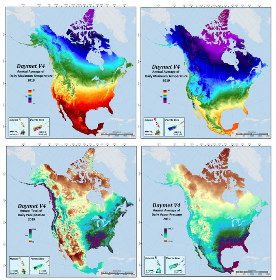
This image features four panels showing Dayment annual climatology data pertaining to temperature and precipitation.
Image Caption

The panels in this image show Daymet Version 4 annual climatologies for maximum and minimum temperature, precipitation, and vapor pressure for 2019.

Originally, Daymet was created to provide near-surface meteorological information for remote areas, or for areas with limited instrumentation, to be used as inputs for driving terrestrial ecosystem models. Since then, applications for its data have expanded significantly.

Access to daily high-resolution gridded surface weather data based on direct observations over long periods is essential for studies and applications pertaining to vegetation (forest, rangeland, crops, agricultural), wildlife (species of interest, biodiversity), soil health, hydrological modelling, remote sensing validation, and as driver data in earth system models. Given this wide variety of applications for Daymet’s data, it’s not difficult to understand why Daymet is among the ORNL DAAC’s most popular data collections.

“People need this type of data. It has a lot of applications in wildlife, in hydrology, many types of vegetation modelling. Large agencies like the USDA Forest Service and USGS have made use of it and we’ve even had veterinarians use it to see how climate affects the spread of pathogens,” said ORNL DAAC Daymet Lead Michele Thornton. “It’s fairly fine resolution at one kilometer and the ORNL DAAC provides a lot of tools and services and a variety of ways for people to get the data that suits their needs.”

The Daymet dataset is distributed by ORNL DAAC, a partnership between NASA and the U.S. Department of Energy (DOE), which released a new and improved version of the dataset—Daymet Version 4—on December 15, 2020.

According to Thornton and her ORNL DAAC colleagues, Daymet Version 4 is an improvement to earlier versions because it provides effective solutions to known issues with sensor and time of observation biases while taking advantage of the latest station observation datasets. For example, algorithm improvements address issues associated with bounded limits to the range of regression estimates in both temperature and precipitation, resulting in better estimations in all variables of the gridded data products. In addition, potential station input biases based on available time of observation were also evaluated for both temperature and precipitation. Cross validation analyses were used to quantify and correct biases related to temperature sensor replacement at high elevation stations. Taken together, these enhancements have resulted in data that is both more accurate and more precise.

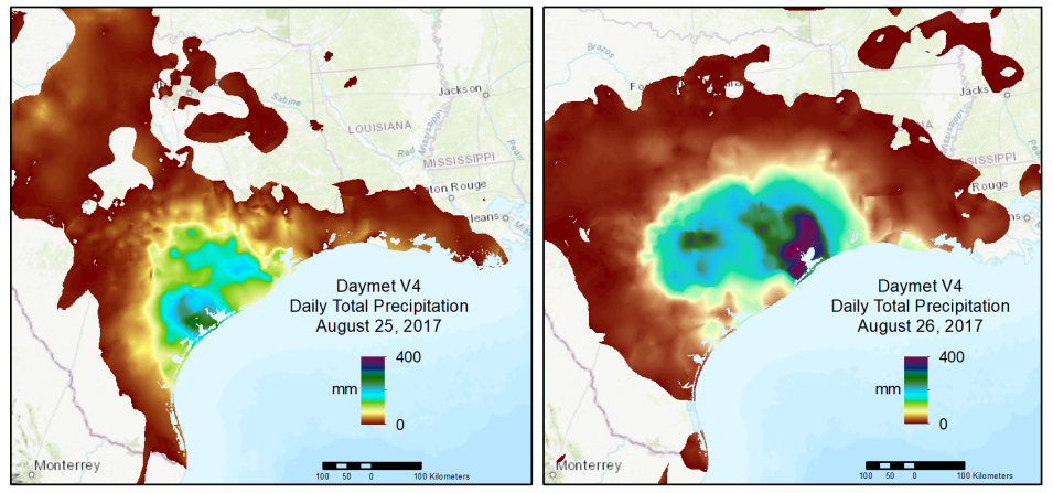
This graphic shows Daymet data pertaining to daily precipitation amounts in southeast Texas during Hurricane Harvey in on August 25 and 26, 2017.2017
Image Caption

This graphic offers a regional view of Daymet Version 4 daily total precipitation over two days as Hurricane Harvey made landfall on Texas and Louisiana in August of 2017.

“I’m excited to have Daymet Version 4 released,” said Thornton. “With this release we are able to provide the user community a continuation of the data project that they expect while addresses some known legacy issues and station-level input bias adjustments. Continuing to implement improvements and provide updates is important to staying relevant.”

Thornton’s assessment of the dataset’s importance is supported by Daymet’s usage statistics. According to metrics from NASA’s Earth Science Data and Information System (ESDIS) Project, more than 80 terabytes of Daymet data were distributed during the 2020 Fiscal Year (October 1, 2019 through September 30, 2020).

Thornton added that, in early January, there were “hundreds of thousands of downloads” from Daymet’s Single Pixel Extraction Tool, which enables users to acquire daily data from the nearest 1 km x 1 km Daymet grid cell for a single geographic point by latitude and longitude in decimal degrees.

The dataset’s utility is also evident in the nearly 400 peer-reviewed papers that have used some aspect of Daymet data since 2012. Some recent uses of Daymet data include peer-reviewed research into the benefits of artificial drainage on soybean yield in the north central United States, the growth and expansion of birch shrubs in continental Canada, hot weather and risk of drowning in children, Avian responses to extreme weather, and heat wave severity and coverage across the United States. The popularity of Daymet also has led to the creation of community-developed open-source scientific command-line software such as daymetr (an R package) and daymetpy (a Python package), both of which are available through ORNL DAAC's Daymet Resources Learning page.

Yet, Daymet’s impressive use metrics and popularity within the scientific community haven’t stopped Thornton and her ORNL DAAC colleagues from working to make Daymet even better. Among the items on their to-do list are incorporating the meteorological data for 2020, which Thornton said is coming soon, and increasing the frequency of data updates.

“There is a community that wants [the data] to be lower latency,” Thornton said. “We are working toward providing data on a monthly basis this summer.”

Daymet began as a research project created to provide daily weather driver data for terrestrial biogeochemical modelling applications. Improvements to this early model and its algorithm led to the development of Daymet Version 1, a Conterminous US (CONUS) data product, in 1999. Daymet Version 2, which included data from a greater number of weather stations and additional updates, was made available through ORNL DAAC in 2013. At the time, data was only available for CONUS, Hawaii, Puerto Rico, Mexico, and southern Canada up to 52 degrees North. The inclusion of data from additional weather stations and further algorithm enhancement led to the development of Daymet Version 3, which was released in 2016, offered spatial coverage of all of North America.

Improvements to Daymet’s core algorithm and bias assessments were supported by the Office of Biological and Environmental Research within the DOE's Office of Science. The standardization, curation and distribution following FAIR data standards of Daymet V4 are supported by funding from NASA through ESDIS and the Terrestrial Ecology Program. ORNL DAAC is responsible for managing, archiving, and distributing data in NASA’s Earth Observing System Data and Information System (EOSDIS) collection pertaining to biogeochemical dynamics, ecology, and environmental processes.

To learn more about the ORNL DAAC data, services, and tools, visit the ORNL DAAC website.

To learn how to use Daymet and its data analysis tools, visit the Learning page on the Daymet website.

To discover and access ORNL data by scientific theme or NASA project, or to see a complete list of available datasets, visit the website’s Get Data page.
Details

Last Updated

Published

Data Center/Project

Oak Ridge National Laboratory DAAC (ORNL DAAC)