Hidden Carbon

Satellites measure the give and take between trees and temperatures.

At the Flathead Lake Biological Station near Missoula, Montana, blossoming cherry orchards announce the arrival of spring. In the surrounding hills, deciduous larch trees don a new coat of green fir, while the evergreens burst with the lush growth of soft young needle clusters.

Flathead Lake researchers Matt Jones and John Kimball watch the colorful march of seasons with interest. But when the two scientists, who specialize in remote sensing, look at the spring landscape, they see more than just bursting buds and unfurling leaves. They also see the blooming trees and plants for their critical role in cleansing the atmosphere of carbon dioxide.

Climate scientists around the world are working to hone their predictions of how much future carbon dioxide will contribute to climate warming. Humans release about eight gigatons of carbon per year, but only about half of that carbon ends up in the atmosphere. The rest presumably disappears into the oceans, land, and forests of the world, and scientists can only account for a fraction of that missing carbon. So Jones and Kimball are among those trying to figure out just how much carbon the world’s plants are absorbing, and when.

Photograph of a deciduous forest changing color during autumn
Image Caption

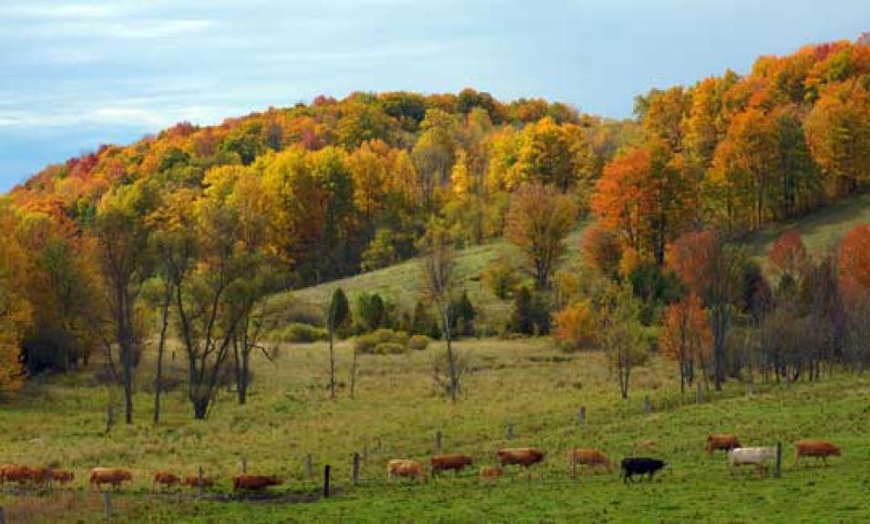
In the fall, trees in this deciduous forest in Northumberland County, Ontario, Canada start to change colors and lose their leaves. As the seasons change from summer to winter, forests slow down their growth and absorb much less carbon from the atmosphere. (Courtesy D. Cronin)

Plants and the climate

Carbon levels in the atmosphere rise and fall with the changing of the seasons. As trees and grasses awaken from their winter slumber, they take a deep breath, sucking in carbon dioxide and exhaling oxygen. Through photosynthesis, plants convert carbon from the atmosphere and water from the soil into the starches, sugars, and cellulose that make up their branches and leaves. Then in the fall, many trees lose their leaves, photosynthesis slows or stops, and plants stop taking up carbon.

As climate warms, plants in many regions are adapting to warmer temperatures by starting growth earlier in the spring, and dropping their leaves later in the fall. That longer growing season allows trees and other plants to absorb more carbon than they used to, sequestering it in their trunks and branches.

Jones said, “You can think of it like a faucet. The timing of when that faucet turns on or off makes a huge amount of difference in how much water runs out of the tap.” Changing the timing of when plants turn on or off, said Jones, can make a big difference in carbon uptake on a global scale. He said, “If the timing of when you turn that faucet off is off by four days, well, four days of carbon uptake on a global scale is a huge amount of carbon.”

Will longer growing seasons increase carbon uptake and help mitigate climate change? Or will other factors like increased drought and fires eventually cut down on the amount of carbon the world’s plants can absorb? Kimball said, “The issue is, which one is winning? What’s the status of the carbon sink?”

A global view

One way to measure when plants turn on in the spring or off in the fall is to look at satellite images that show the color of the land surface, a method that researchers have been using for years. As forests grow new leaves in the spring, images from satellite sensors like NASA's Moderate Resolution Imaging Spectroradiometer (MODIS) show large swaths of the landscape turning from brown to green in the space of a few weeks. Optical sensors such as MODIS measure changes in visible and near-infrared wavelengths. These data, combined with field measurements, have shown that growing seasons are starting earlier and lasting longer in some places, as temperatures get warmer.

Photograph of clouds obscuring the Amazon rainforest
Image Caption

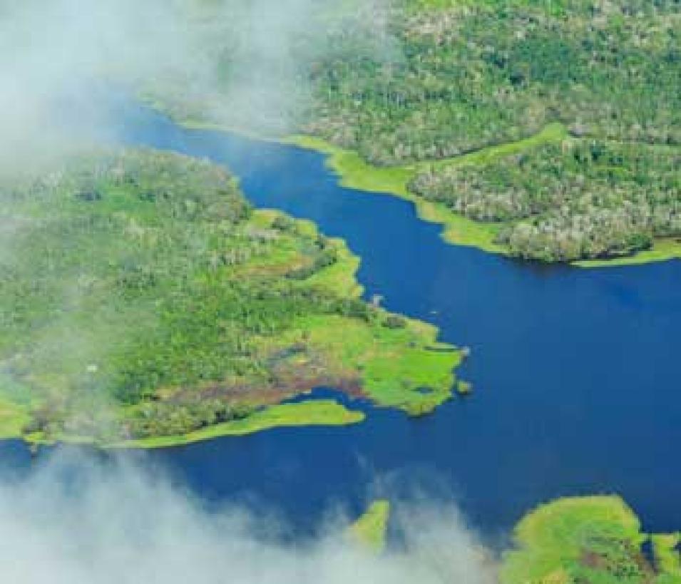
Clouds obscure an aerial view of the Amazon rainforest, near Manaus, Brazil. Although it is one of the world’s fastest-growing rainforests, the Amazon forest is hidden from satellite eyes for months at a time because of thick clouds. (Courtesy N. Palmer/CIAT)

The vivid MODIS images cannot capture all of the seasonal changes in the world’s plant cover, however. Kimball said, “One problem with satellite remote sensing in visible wavelengths is that we live on a cloudy planet.” For example, the Amazon rainforest, one of the world’s fastest-growing forests, is covered in clouds for months at a time, hiding it from the prying gaze of optical satellite sensors. Meanwhile, forests in the far north are cloaked in darkness for part of the year, and MODIS needs light to take pictures. “Vegetation phenology events, like bud burst and leaf unfolding, happen on very short time scales. So if these events happen to occur under cloudy conditions we could miss them in the satellite optical record,” Kimball said.

Some forests do not even need to hide beneath clouds or darkness to avoid giving away their secrets. Evergreen forests, like the boreal forests of North America and Europe, keep their needles all winter, so that visible imagery shows little change from season to season. Kimball said, “If you have an evergreen needle-leaf forest system, you don’t really get a seasonal variation in vegetation color or greenness.” Even without changes in color, though, forests have a distinct growing season when they take up large amounts of atmospheric carbon.

Another view of the forest

To track changes in vegetation that are not visible to the naked eye, Jones and Kimball started using another type of data from a satellite sensor called a passive microwave sensor. Jones said, “Microwave sensors have the advantage that they can effectively see through clouds. And we can retrieve the data totally independently of solar illumination.” Low-frequency microwaves emanate year-round from the Earth’s surface, a natural by-product of tiny vibrations in all matter. The microwave signals vary with the temperature and composition of the Earth, which means that researchers can use these emissions to measure differences in the water content of the Earth’s surface, discerning changes in vegetation biomass, ice from water, frozen ground from thawed ground, and dry soil from moist soil.

Jones and Kimball had started looking at phenology in northern forests by measuring when the ground freezes and thaws, a cycle that is closely tied to growing seasons in the far north. But to get at that data, the researchers first had to extract the ground data from a morass of extra microwave signals emanating from the trees and shrubs that covered the ground. These vegetation data masked the signals the researchers were trying to see, and initially the researchers saw it as noise. Then they stumbled on a new idea. Jones said, “We realized that the signal that we were trying to get rid of could be used to look at vegetation on a really large scale.”

Into the jungle

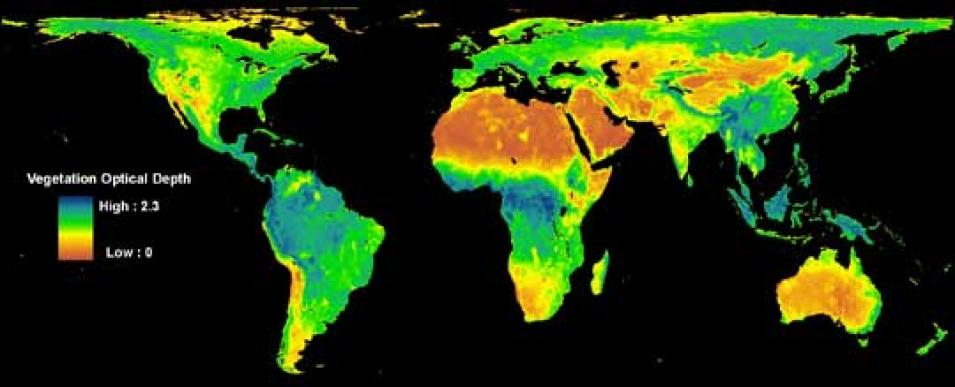
Some of the best passive microwave data for looking at vegetation comes from the Advanced Microwave Scanning Radiometer for EOS (AMSR-E) sensor aboard NASA's Aqua satellite. The microwave data give researchers details about seasonal vegetation changes, including the density of leaves and branches, water content, and the amount of plant material—or biomass—in the uppermost layers of a forest, allowing scientists to more accurately see when the world’s forests shed their leaves or grow new ones.

Data image showing the density of trees and plants across the globe
Image Caption

This map shows vegetation optical depth, a measure of the density of trees and plants on the Earth’s surface. Researchers are using these data to study plant cover in places like the Amazon rainforest, which are often invisible to other satellite sensors because they are hidden under thick clouds. Data are from the Advanced Microwave Scanning Radiometer for EOS (AMSR-E). Orange shows areas with little to no vegetation cover, while dark green and blue indicate the areas with the most vegetation. (Courtesy M. Jones et al. 2011, Remote Sensing of the Environment)

“We’re getting a more complete picture now,” Jones said. “We can start to say when trees start taking up water, before they even produce chlorophyll. Then we can measure greenness and biomass through the growing season. And then at the end of the season we can also measure when biomass actually falls to the ground.” In 2011, Jones, Kimball, and their colleagues at Flathead Lake published a new study from the AMSR-E data, which they obtained from NASA's National Snow and Ice Data Center Distributed Active Archive Center (NSIDC DAAC).

The new study and database includes a map of global vegetation data derived from AMSR-E data, and is already helping to fill in knowledge gaps about the Earth’s carbon cycle. In the Amazon, for instance, researchers had thought that the rainforest grew relatively constantly with few changes between seasons, absorbing the same amount of carbon year-round. The AMSR-E data gave the team a surprise. “Until recently we’ve been trying to determine whether there’s even a coherent phenology signal,” Kimball said, “Now we are seeing a seasonal phenology signal of green-up and peak biomass.” Although preliminary, the results suggest that the giant carbon sink in the Brazilian tropics might perk up during the dry season, grow vigorously when the sun comes out, and slow down in the wet season when clouds limit sunlight.

Kimball and Jones hope that their new vegetation data will help climate scientists better understand how much carbon the world’s forests sequester from the atmosphere. And that information is critical for predicting future changes in climate. Jones said, “I wouldn’t say it’s going to completely change our carbon cycle models, but it is going to fine-tune them and get a better level of accuracy.

References

Jones, M. O., L. A. Jones, J. S. Kimball, and K. C. McDonald. 2011. Satellite passive microwave remote sensing for monitoring global land surface phenology. Remote Sensing of the Environment 115:1,102-1,114, doi:10.1016/j.rse.2010.12.015.

Kim, Y., J. S. Kimball, K. C. McDonald, and J. Glassy. 2011. Developing a global data record of daily landscape freeze/thaw status using satellite passive microwave remote sensing. IEEE Transactions on Geoscience and Remote Sensing 49(3), doi:10.1109/TGRS.2010.2070515.

For more information

NASA Land Processes Distributed Active Archive Center (LP DAAC)

NASA National Snow and Ice Data Center DAAC (NSIDC DAAC)

Advanced Microwave Scanning Radiometer-Earth Observing System (AMSR-E)

Moderate Resolution Imaging Spectroradiometer (MODIS)

About the remote sensing data used
Satellites Aqua Aqua Terra Terra
Sensors Japanese Space Agency Advanced Microwave Scanning Radiometer- Earth Observing System (AMSR-E) AMSR-E Moderate Resolution Imaging Spectroradiometer (MODIS) MODIS
Data sets AMSR-E/Aqua Daily EASE-Grid Brightness Temperatures Daily Global Land Surface Parameters Derived from AMSR-E Land Cover Type Leaf Area Index
Resolution 25 kilometer 25 kilometer 500 meter 1 kilometer
Parameters Brightness temperature Vegetation canopy microwave transmittance Land cover Vegetation
DAACs NASA National Snow and Ice Data Center Distributed Active Archive Center (NSIDC DAAC) NASA NSIDC DAAC NASA Land Processes DAAC (LP DAAC) NASA LP DAAC

(Photograph of maple leaves in title graphic courtesy of Joe DSilva/flickr)
Details

Last Updated

Published

Data Center/Project

Land Processes DAAC (LP DAAC)
National Snow and Ice Data Center DAAC (NSIDC DAAC)