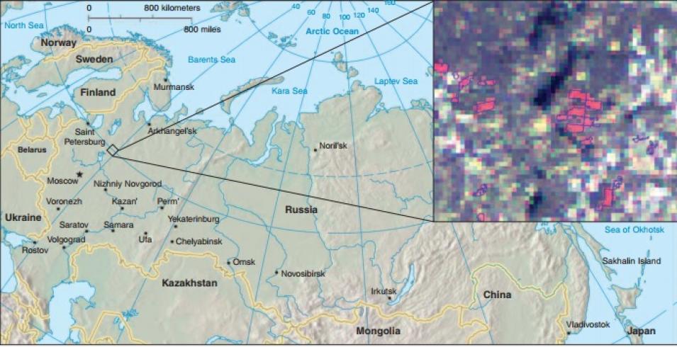
To distinguish forested areas from clear-cuts, Stibig and Bucha looked for color differences. “In MODIS images, the contrast between coniferous forest and clear-cut is quite strong, so we can spectrally detect this change quite well,” Stibig said. The scientists then designed a computer program to automatically identify clear-cuts. Their method caught 90 percent of clear-cuts larger than 15 hectares (37 acres), and about 60 to 75 percent of clear-cuts between 10 and 15 hectares (25 to 37 acres).
Stibig and Bucha’s study demonstrates that the MODIS data could be useful in large-scale efforts to map change in Russia’s boreal forests. Bucha said, “The objective of this study was to see whether we could estimate forest change for large areas. MODIS data are perfect because they are freely available and easy to get.”
New view of a changing landscape
Stibig and Bucha see their study as a first step in coherently mapping the changes in Russian forest cover. Stibig said, “The idea is to test such forest monitoring approaches in a large area, for example, for all the boreal forests in the northwest of Russia, in collaboration with Russian scientists.” Such efforts could help support sustainable forest management and contribute to climate change research. While both Stibig and Bucha have now moved on to other projects, other researchers are picking up where they left off, expanding the idea to larger areas and combining MODIS with other sensors. The next challenge is to turn these short-term forest research projects into a long-term data series.
Tom Stone, a researcher at the Woods Hole Research Center, said, “Remote sensing is an ideal tool to study Russia. But we need to monitor these areas on a continuing basis. If we have just one date, we can’t say anything about the rate of change.” Mapping Russian forests over time could help researchers understand how changes in the extent of the carbon-rich Russian forests might affect global climate change. “Russia’s forests are the world’s largest, so they are very important in terms of understanding the global carbon cycle,” Stone said. “But we don’t even know whether they are an overall source of carbon dioxide to the atmosphere, or a sink for carbon dioxide coming out of the atmosphere.”
Forestry experts say that such efforts might also help people understand the limits of a seemingly endless resource. To keep the logging industry viable, loggers have to use harvesting methods that keep forests healthy. Laestadius said, “Every country has had the same problem historically. It just depends on when you run into a wall and you see that the resource will run out.”
References
Achard, F., et al. 2006. Areas of rapid forest-cover change in boreal Eurasia. Forest Ecology and Management, 237:1-3, 322−334.
Bartalev, S., A. Belward, D. V. Erchov, and A. S. Isaev. 2003. A new SPOT4-VEGETATION derived land cover map of Northern Eurasia. International Journal of Remote Sensing 24(9): 1977−1982.
Bucha, T., and H. J. Stibig. 2007. Analysis of MODIS imagery for detection of clear-cuts in the boreal forest of northwest Russia. Remote Sensing of the Environment 112: 2416−2429.
Houghton, R. A., et al. 2007. Mapping Russian forest biomass with data from satellites and forest inventories. Environmental Research Letters 2(4), doi:10.1088/1748-9326/2/4/045032.
For more information
NASA Level-1 and Atmosphere Archive and Distribution System Distributed Active Archive Center (LAADS DAAC)
Moderate Resolution Imaging Spectroradiometer (MODIS)
MODIS Rapid Response System
European Commission Joint Research Center institute
Global Forest Watch Russia
Woods Hole Research Center
| About the remote sensing data |
| Satellite |
Terra |
| Sensor |
Moderate Resolution Imaging Spectroradiometer (MODIS) |
| Data set |
Level 1B Calibrated Radiances |
| Resolution |
250 and 500 meter |
| Parameter |
Surface reflectance |
| DAAC |
NASA Level-1 and Atmosphere Archive and Distribution System Distributed Active Archive Center (LAADS DAAC) |


