The atlas is free for anyone to use and was started by GIS software company Esri. The company is the developer of ArcGIS, one of the most popular mapping and data analysis platforms in the world. Esri launched the Living Atlas in 2014 with the initial release of their Software as a Service (SaaS) mapping platform ArcGIS Online. Today, the atlas features thousands of datasets from governmental agencies, industry partners such as non-governmental organizations, and Esri. The site is used by Esri’s millions of users working in various fields who come from state and county governments, federal agencies including NASA, NOAA, EPA, and FEMA, and private industry and community organizations.
To make the site accessible to so many different users, the atlas has attractive, easy-to-use navigation for finding and previewing datasets, and the product pages themselves include helpful overview information, metadata, and map and scene viewers to immediately visualize the data. The site and its top-shelf data cater to both novice and expert users.
Bringing NASA Data to Living Atlas
The call to add NASA data to the collection came time and again from users NASA spoke to at conferences, workshops, and other events. “We heard over and over ‘I go to Living Atlas first—is NASA in Living Atlas?’” said Schwizer.
Initially, NASA data were used as the backbone of products developed in-house by Esri. “For a long time, we would actually use Earthdata Search APIs to access the data and then build our own web services around it for users,” said Charlie Hoffman, Esri’s account manager for NASA. “In the last couple of years, we’ve been partnering with NASA to host and manage its own GIS-formatted data layers so the agency can get maximum attribution.”
The partnership between NASA and Esri is in the form of a cooperative Space Act Agreement to create a pipeline for the agency to develop and submit NASA-branded datasets for the atlas. As part of the agreement, Esri is advising NASA on how to make its datasets plug-and-playable with GIS software as well as recommending the kinds of NASA products atlas users would most like to see.
Schwizer said one of the key aspects of the site is that it is not a dumping ground for any and all GIS-enabled data. “The data is very curated, and it must meet high quality requirements before it’s added to the repository.”
NASA, Esri, or anyone else wanting to add products to the atlas must satisfy a list of specific, user-friendly-focused requirements. For example, datasets have to be publicly accessible without requiring any sort of log in. The products must also include Esri-defined metadata and a representative image. And in the spirit of user-friendliness, product overview descriptions must be understandable to nonscientific audiences.
Once the checklist is complete, the submitting organization nominates the datasets for inclusion into the atlas. The nomination process includes an automated completeness review of the dataset package to immediately notify submitters of any elements that are missing or need improvement. If a dataset scores an 80 or higher, it is passed to an Esri curator who will work with the submitter to finalize the submission. When NASA’s nominations are approved, the datasets are added to the site, listed as managed by “NASA_Earthdata” and labeled with the green “Authoritative” badge to highlight that the product comes from the highest credible source.
NASA's Top Data
NASA Earthdata is continuously adding new collections to the atlas that receive thousands of views. Currently, the top three most popular NASA-managed datasets are:
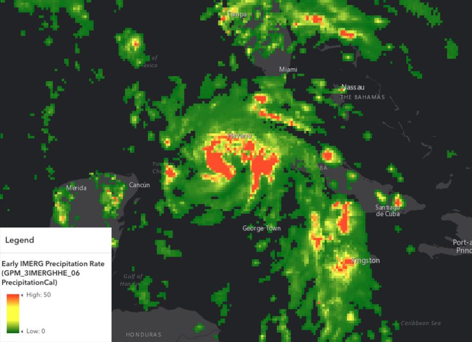
- Early IMERG Precipitation Rate (GPM_3IMERGHHE_06 PrecipitationCal: This is an image service derived from the Integrated Multi-satellitE Retrievals for Global Precipitation Measurement (IMERG/GPM) Early dataset showing global precipitation rates (mm/hr) in 30-minute intervals approximately four hours after observation.
- Tropospheric Emissions: Monitoring of Pollution (TEMPO) Version 03 Level 3 Gridded Nitrogen Dioxide (NO2) Tropospheric Vertical Column (BETA): This data layer provides measurements on the amount of nitrogen dioxide in the troposphere and is available as approximately one-hour scans for daylight hours over North America from August 2023 to present.
- Gridded Population of the World, Version 4 (GPWv4): Population Density, Revision 11: This dataset offers estimates of human population density (number of persons per square kilometer) based on counts consistent with national censuses and population registers for the years 2000, 2005, 2010, 2015, and 2020.
The overall most popular atlas product using NASA data is Esri’s Satellite Thermal Hotspots and Fire Activity, which draws on the Land, Atmosphere Near real-time Capability for Earth observation (LANCE) VNP14IMG_NRT active fire detection product. The atlas product pinpoints fires detected in the last seven days by the Visible Infrared Imaging Radiometer Suite (VIIRS) instruments and has received more than 118 million views since it was created in 2020.
Whether the NASA Earth data are managed by the agency or Esri, their view counts are enormous and suggests how broadly the data are used by GIS professionals, decision-makers, scientists, and other interested people. Including Earth data in the atlas is a great step along NASA’s ongoing journey to making the information as open and freely accessible as possible. See for yourself by visiting the ArcGIS Living Atlas of the World to discover how Earth observation data formatted for GIS are great together for the benefit of us all.
