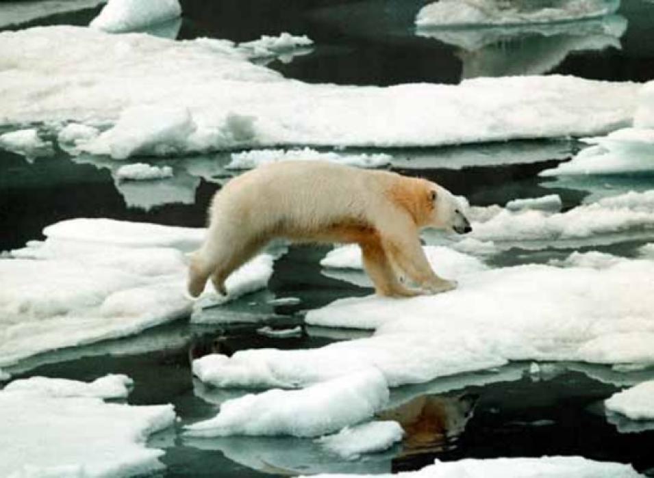
Drowning polar bears, seals under stress, changing global weather patterns, and blue icebergs steadily dripping water: these are the images that accompany discussions of disappearing Arctic sea ice. But does the dwindling icecap of the north signal real change for the Arctic and for the planet? For as long as human beings have taken notice, millions of square miles of Arctic sea ice have covered a roughly predictable area. While melting back during the summer and growing during the winter, the sea ice has kept the Arctic cool and may have helped stabilize Earth's weather patterns for the past eight thousand years.
Arctic Sea Ice on the Wane: Now What?
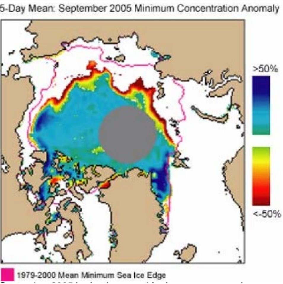
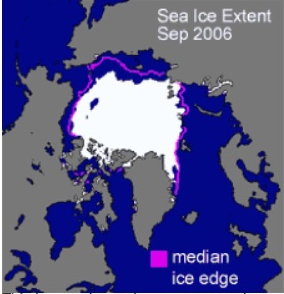
September 2005 broke the record for low summer sea ice extent, the measure of area containing at least 15 percent ice. The ice extent is shown by the edge of the colored region. The long-term average minimum extent contour (1979 to 2000) is in magenta. The grey circle indicates the area where the satellite does not take data. Data are from the Special Sensor Microwave/Imager (SSM/I). (Courtesy NSIDC)
However, sea ice growth and melt are no longer in the same balance, and the ice is disappearing. Scientists from all over the world are keeping watch: measuring Arctic sea ice decline, studying what that decline will mean for life on Earth, and ascertaining the future of sea ice.
A record disappearance
Arctic sea ice is simply frozen sea water atop the Arctic Ocean. But sea ice is far away from almost everyone and everything on Earth. So why does it matter? Walt Meier is one of a team of scientists at the National Snow and Ice Data Center (NSIDC) that monitors Arctic sea ice year round. Meier said, "Sea ice has a high albedo, meaning it reflects a lot of sunlight. Sea ice absorbs less solar energy than the darker ocean water, beneath, and that keeps the Arctic cool." If you think of the planet as a house, the poles play the role of the whole-house air conditioner, supplying cool air masses to lower latitudes. Meier said, "Contrasting temperatures set up circulations in the atmosphere and oceans that lead to weather patterns around the globe."
Given the importance of Arctic sea ice to global climate, accurately measuring the ice is crucial to understanding if its once-predictable patterns are changing. However, according to Meier, taking measurements in the frigid, isolated, and expansive geography of the Arctic was difficult until the dawn of the satellite era. "Ships can take observations, which can help tell us about ice formation, but few icebreakers can push all the way through the ice to the North Pole, so they have to skim around the edges of the ice," Meier said. "Plus, single ship transects don't give a good regional picture of ice conditions." In the 1950s, the United States government began compiling ship and airplane observations into sea ice charts, with inconsistent results.
In 1978, after deploying experimental satellites in the 1960s and early 1970s, NASA launched the Nimbus-7 satellite carrying the Scanning Multichannel Microwave Radiometer (SMMR). Sea ice records from this sensor are now managed at NASA's NSIDC Distributed Active Archive Center (DAAC). SMMR afforded a bird's-eye view of nearly the entire Arctic region, recording consistent year-round sea ice concentration data in all weather conditions every other day. Following SMMR, a series of satellites have circled the poles; their sensors have created a long record of sea ice conditions. "Sea ice has one of the longest satellite records of any environmental aspect on Earth," Meier said.
What kind of sea ice data do satellites collect? Some satellite sensors measure the albedo, or the fraction of solar energy reflected from ocean waters and sea ice. Passive microwave sensors, like SMMR, measure the microwave energy emitted by ocean waters and sea ice, called brightness temperatures. The contrast in brightness temperatures between surfaces allows scientists to distinguish the sea ice from the water. From there, researchers can determine sea ice extent, or the area of ocean covered by at least 15 percent sea ice. "Currently, extent is the longest-running and most accurate measure of sea ice that we can get with satellites," Meier said.
The long record of sea ice indicates that the Arctic sea ice never melts completely, but fluctuates with the seasons. Sea ice extent increases during the cold, dark winter, and it decreases during the warmer, brighter Arctic summer. But now, sea ice extent measurements are breaking the patterns that satellites have recorded since 1978. "Sea ice is disappearing," Meier said. "Every summer since 2002 has brought record or near-record lows. This is the first time we've seen such continuously low sea ice extent in the satellite record."
Data from the Special Sensor Microwave Imager (SSM/I) and Advanced Microwave Scanning Radiometer-EOS (AMSR-E), also managed at NSIDC, are especially important for Meier's sea ice research. Based on sea ice concentration data from these instruments, Meier has calculated that Arctic sea ice would typically cover approximately seven million square kilometers (2.7 million square miles) at the end of the summer melt season; now, that number is down to six million square kilometers (2.3 million square miles). "That's a loss of sea ice extent the size of the state of Alaska in only twenty-eight years," Meier said.
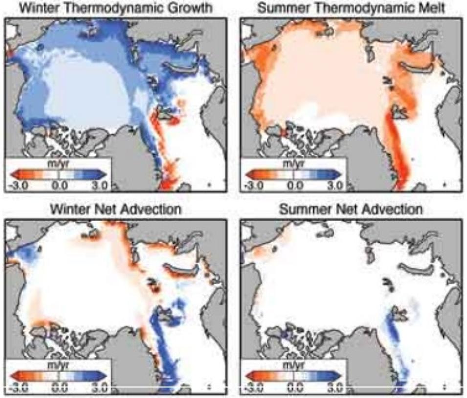
Where and how Arctic sea ice builds up and thickens is influenced by two processes: melting/growing, and horizontal transport of the ice, or advection. These maps show model simulations of the mean thickness changes from these processes in winter (October to April) and summer (May to September) for 1948 to 2003, with red showing negative growth/advection, and blue showing positive growth/advection. (Courtesy Ron Lindsay)
Following the summer low, scientists would expect the sea ice to bounce back to normal during the following winter. However, winter refreezing patterns are also changing. "In the past, less ice in the summer would mean more of the ocean would be exposed to the air once winter came, and the ice would grow rapidly and recover to normal pretty quickly," Meier said. "Sea ice at the end of the winter was always really stable, around fifteen and-a-half million square kilometers [six million square miles], give or take a few hundred thousand." But now, the ice is not recovering to normal winter levels. "Winter air temperatures are higher, the ocean is warmer, and that is delaying the onset of refreezing in the fall," Meier said. In March of 2005, the sea ice area bottomed at a record wintertime low of only 14.5 million square kilometers (5.6 million square miles). "This is well outside what we've seen in the past."
Sea ice in context
Is this striking downward trend in sea ice merely a blip in the natural long-term "ups and downs" of sea ice? Scientist Ron Lindsay, of the University of Washington Applied Physics Laboratory, wondered this, too. He said, "In the 1990s, we thought it was all driven by a pressure fluctuation between the Arctic and the lower latitudes, called the Arctic Oscillation which seemed to explain much of the interannual variability of the ice." But in 1996, the Arctic Oscillation cycled from a strong positive phase, which normally brings warmer temperatures and pushes ice out of the Arctic Ocean, to its negative phase, which normally brings cooler temperatures and keeps ice sequestered in the Arctic. But despite the change, the sea ice kept declining.
The significance of the disappearing sea ice, within the context of the Earth's complex climate system, is still unfolding. Yet Meier and Lindsay agree that the sustained downward trend in sea ice is compelling evidence of a changing system. Meier said, "Things like the Arctic Oscillation, the Pacific Decadal Oscillation, El Niño, the Southern Oscillation—all of these fluctuations make for a complex system. But the trend of the sea ice decline is so strong that we don't believe it's a product of natural variability. We just don't doubt its significance."
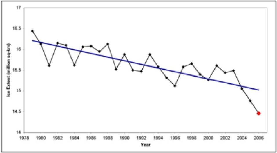
Arctic sea ice melts back during summer and grows or "recovers" during winter. The winter maximum extent is usually reached in March. March 2006 mean sea ice extent, indicated by the last dot at the far right, was 300,000 square kilometers (115,860 square miles) less than the 2005 record, and 1.2 million square kilometers (463,000 square miles) below the 1979 to 2000 mean. (Courtesy NSIDC)
Lindsay put the trend's significance this way: "Our hypothesis is that we've reached the tipping point." In climate science, reaching a tipping point means that a stable climate system has changed direction. A tipping point can happen when a positive feedback takes hold, meaning that a small change in one direction leads to yet further change in the same direction. Lindsay's example of a positive feedback is a ball rolling down a sloping plank, gathering momentum as it travels down the incline. "For sea ice," Lindsay said, "the positive feedback is that increased summer melt means decreased winter growth and then even more melting the next summer, and so on."
Reaching a tipping point can also mean that one climate regime has shifted to another, and that switching back would take a major change. This recalls the image of the ball rolling down the incline. While it might be possible to reverse the direction of the rolling ball and push it back up the plank, it would probably be quite difficult to do. In the case of the sea ice, reverting to conditions that favor normal levels of summertime sea ice would require an enormous export of heat out of the system.
Scientists have wondered if natural forces could reverse the positive feedback of melting sea ice before we reach an ice-free summer ocean in the Arctic. Working with satellite data, as well as ice charts and other observational data, Lindsay has plumbed the possibilities using climate models. "Perhaps a cooling period could reverse the situation," Lindsay said. "But with global warming, temperatures are only bound to rise." And even a relatively powerful cycle, like the Arctic Oscillation in its negative phase, would not be enough to reverse the trend. "Without cooling, none of these climate regimes would matter," Lindsay said.
With little chance of a natural change sparking an increase in sea ice growth, a popular question in the news media has been, "When will we have an ice-free Arctic?" Lindsay, however, does not see that as the central concern. "When we talk about an ice-free Arctic, where the bulk of the basin is ice-free, that's not really as important as measuring and understanding the gradual decline," he said. "Even when we still have 10 to 20 percent of today's summer ice, that will already be a cause for big changes in the circulation and ecology of the oceans." In other words, we will not have to wait for an ice-free Arctic to witness dramatic changes.
Lindsay wants to focus his upcoming research on the "why?" behind the sea ice decline. He said, "Why isn't the ice regrowing more in the winter? What is the fate of that additional heat coming into the system during the summer? Why have we reached a tipping point, in the first place?" These questions are important to understanding both what is happening now, and what will happen in the future.
"When I say the Arctic has reached a tipping point, it's not like the ball just fell off the desk, one day," Lindsay said. "The ball simply started rolling down a ramp. It's the beginning of a process, not a sudden accomplishment." Monitoring that metaphorical ball as it rolls down the ramp is an important way for scientists to understand the changes to come.
Understanding sea ice change
As Arctic sea ice disappears, scientists seek to improve their measurements and analyses so that they can better understand future change. Ron Kwok is one of a team of scientists at NASA's Jet Propulsion Laboratory who are focusing their efforts on sea ice thickness, rather than extent. Kwok said, "The holy grail of Arctic sea ice is thickness. If you don't know how thick the ice is, you don't know much about the volume of the ice. We know the sea ice is disappearing. But, the question we want to understand is how fast it is being depleted by volume." Thickness and volume are crucial to understanding the future of sea ice because if the ice is thinning, it will melt more quickly than thick ice would. Understanding thickness is key to understanding how quickly we are approaching a nearly ice-free summertime Arctic.
Because of the limitations of field observations, Kwok believes that satellite sensors provide the best vantage for measuring sea ice thickness. "It's difficult to come up with answers based on field data," Kwok said. "Satellites really are the best way to provide a large-scale view of the ice." Satellite sensors measuring sea ice thickness rely on two measurements: simple records of elevation between one surface and another; and differences in reflectance between various surfaces, with ice being highly reflective, snow less so, and water the least reflective. Kwok is using reflectance and elevation profiles from the Geoscience Laser Altimeter System (GLAS) sensor on the NASA Ice, Cloud, and Land Elevation Satellite (ICESat), data archived at NSIDC. To actually see images of where sea ice has moved or broken apart, he is also using Synthetic Aperture Radar data from Canada's RADARSAT satellite, archived at NASA's Alaska Satellite Facility (ASF) DAAC.
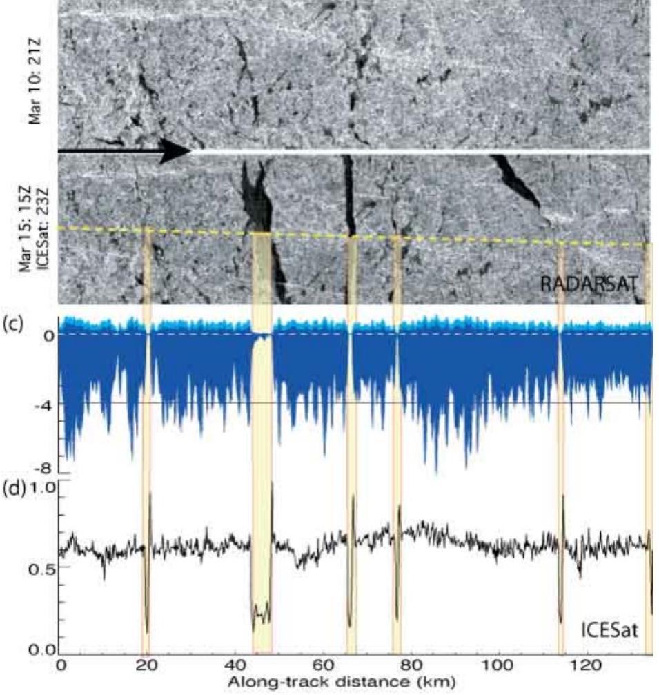
A combination of data from two different satellites provides the information needed to calculate sea ice thickness. The image at the top shows an area of sea ice north of Ellesmere Island. Leads, or fractures in the ice, are darker gray. The black graph at the bottom of the image (d) shows elevation data; yellow bars show correspondence between leads and elevation data. In between, dark blue indicates sea ice thickness, with snow on top of the ice in light blue (c). (Courtesy Ron Kwok)
Analyzing and comparing the reflectance, elevation, and visual imagery from the two satellites, Kwok can more easily determine and confirm the thickness of sea ice. "For example, let's say ICESat flew over a lead, or fracture in the ice. The data would indicate a dip in elevation and a change in reflectance between the sea ice and the open water, while the RADARSAT imagery would confirm visually that a lead had opened," Kwok said "The combination of the two data sources is the best way, because the imagery helps us make sense of the elevation profiles and also confirms that we're actually seeing what we think we're seeing."
With the existence of the lead confirmed, Kwok's team could more confidently use the reflectance and elevation data in calculating the freeboard, or the amount of ice above the waterline. The freeboard calculation would then provide the information necessary to calculate the total thickness of the sea ice. However, because the result from one calculation feeds into the next calculation, the possibility for magnification of error is large. Kwok and his team want to reduce this possibility for error. "Right now, we're trying to interpret the results of our work," Kwok said. "We need to understand the limitations of using ICESat data this way, and define how confident we are in the results. ICESat provides the best information available to help U.S. scientists determine sea ice thickness. So this data is truly compelling."
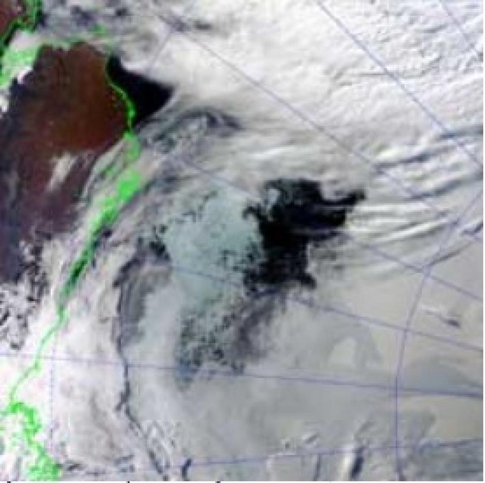
An unusual area of open water surrounded by persistent ice, captured in this MODIS image in mid-September, appeared during the melt season. The feature, called a polynya, is the dark area of open water surrounded by sea ice. To the left is the coastline of Alaska; out of the field of view to the right is the North Pole. (Courtesy NSIDC)
Because thinner ice means a faster decline in sea ice extent, the question of sea ice thickness is also an important piece of Lindsay's ongoing big-picture work on Arctic climate. Lindsay said, "We believe that Kwok's sea ice thickness data could be an important piece of information for our work with large-scale climate models." These models will focus on the possible future of the Arctic sea ice, especially the changes it will undergo from the ongoing influx of heat, and the global influences it will have once it reaches a new stabilized state or "point of no return."
Even if we are only at the beginning of the metaphorical ball rolling down the incline, sea ice scientists are watching that ball carefully. "An Earth without Arctic sea ice in even part of the year," Meier said, "will be a dramatically different planet."
September 2006 sea ice
Following the record low Arctic sea ice minimum of 2005, scientists at NSIDC watched the 2006 melt season closely using satellite data.
The final numbers, which NSIDC announced on October 3, 2006, indicated that the melting season came to a close on September 14 with 5.7 million square kilometers (2.2 million square miles) of sea ice coverage. This was the fourth lowest single-day extent of the twenty-nine-year satellite record. The average sea ice extent for the entire month of September was 5.9 million square kilometers (2.3 million square miles), the second lowest September extent on record, missing the 2005 record by 340,000 square kilometers (131,000 square miles).
Including 2006, September sea ice is declining at a rate of approximately 8.6 percent per decade, or 60,421 square kilometers (23,328 square miles) per year. The NSIDC science team reported that at this rate, the Arctic Ocean will have no ice in September by the year 2060. NSIDC scientist Mark Serreze said, "The reduction in summer sea ice is a bad omen for animals like the polar bear, which need sea ice for their survival."
The science team noted that high temperatures throughout the year set the ice up for huge losses by the end of the melt season, but cooler temperatures in August prevented 2006 from setting a new record.
The 2006 season was also marked by an unusual new feature in the ice. A polynya the size of the state of Indiana formed in the Beaufort Sea, north of Alaska. Serreze said, "Given its large size, the polynya no doubt contributed to this year's low sea ice extent numbers." Scientists plan to use satellite data to formally study the polynya and better understand its unprecedented formation in the Beaufort Sea.
"I'm not terribly optimistic about the future of the ice," Serreze said. "Although it would come as no surprise to see some recovery of the sea ice in the next few years—such fluctuations are part of natural variability—the long-term trend seems increasingly clear. As greenhouse gases continue to rise, the Arctic will continue to lose its ice. You can't argue with the physics."
References
Arctic sea ice news 2006. National Snow and Ice Data Center. Accessed August 23, 2006.
Kwok, R., G. F. Cunningham, H. J. Zwally, and D. Yi. 2006. ICESat over Arctic sea ice: Interpretation of altimetric and reflectivity profiles. Journal of Geophysical Research 111: C06006, doi:10.1029/2005JC003175.
Kwok, R., H. J. Zwally, and D. Yi. 2004. ICESat observations of Arctic sea ice: A first look. Geophysical Research Letters 31, L16401, doi:10.1029/2004GL020309.
Lindsay R. W., and J. Zhang. 2005. The thinning of Arctic sea ice, 1988-2003: Have we passed a tipping point? Journal of Climate 18: 4879-4894.
Meier, W., M. Marquis, M. Kaminski, and R. Weaver. 2004. NASA EOS sensors demonstrate potential for multiparameter studies of Arctic sea ice. EOS 85(46): 481, 488-489.
Sea ice decline intensifies. National Snow and Ice Data Center. Accessed August 18, 2006.
For more information
NASA Alaska Satellite Facility Distributed Active Archive Center (ASF DAAC)
NASA National Snow and Ice Data Center DAAC (NSIDC DAAC)
University of Washington Applied Physics Laboratory
Scanning Multichannel Microwave Radiometer (SMMR)
Special Sensor Microwave Imager (SSM/I)
Ice, Cloud, and land Elevation Satellite (ICESat)
Advanced Microwave Scanning Radiometer - Earth Observing System (AMSR-E)
| About the remote sensing data used | ||||
|---|---|---|---|---|
| Satellites | Nimbus-7/Defense Meteorological Satellite Program (DMSP) | Aqua | Ice, Cloud, and land Elevation Satellite (ICESat) | RADARSAT |
| Sensors | Scanning Multichannel Microwave Radiometer (SMMR)/Special Sensor Microwave/Imager (SSM/I) | Advanced Microwave Scanning Radiometer–Earth Observing System (AMSR-E) | Geoscience Laser Altimeter System (GLAS) | Synthetic Aperture Radar (SAR) |
| Data sets | Sea Ice Concentrations from Nimbus-7 SMMR and DMSP SSM/I Passive Microwave Data | AMSR-E/Aqua Daily L3 12.5 km Tb, Sea Ice Concentration, & Snow Depth Polar Grids | GLAS/ICESat L2 Sea Ice Altimetry Data | RADARSAT Standard SAR |
| Resolution | 25 kilometers | 12.5 kilometers | 60 meters | 100 to 500 meters |
| Parameters | Brightness temperature | Brightness temperature, sea ice concentrations, snow depth over sea ice | Elevation, reflectance | Backscatter |
| DAACs | NASA National Snow and Ice Data Center Distributed Active Archive Center (NSIDC DAAC) | NASA NSIDC DAAC | NASA NSIDC DAAC | NASA Alaska Satellite Facility DAAC (ASF DAAC) |
