Dr. Melinda Webster

Data from NASA’s NSIDC DAAC helps scientists like Dr. Melinda Webster study sea ice and overcome the challenges of working in the Arctic’s inhospitable environments.

Dr. Melinda Webster, Research Assistant Professor at the Geophysical Institute of the University of Alaska Fairbanks

Research Interests: Improving our understanding of how the atmosphere, snow cover, and sea ice interact with one another over seasonal and decadal time scales, and how changes associated with a warming climate are affecting those interactions and snow conditions. Finding new ways to combine satellite data to expand our capability to monitor snow and melt pond conditions in the Arctic.

Research Highlights: Conducting scientific research in the Arctic is full of challenges. It’s dangerous, expensive to get to and spend time in, and home to such extreme cold that, in the words of Dr. Melinda Webster of the University of Alaska Fairbanks, it’s “excellent at breaking instruments.” These conditions aren’t just inconvenient or uncomfortable, they make it difficult to obtain observations in the region, which Webster needs for her research on Arctic sea ice. Fortunately, Webster has an array of NASA Earth data to help her overcome these challenges.

Sea ice is an integral part of the Arctic Ocean and, during the dark winter months, the body of water is almost entirely covered by ice. In summer, some of this ice melts due to warmer temperatures and increased sunlight. By mid-September, sea ice in the Arctic typically reaches its minimum thickness and extent. Then, as the days pass and the season’s change from fall to winter, the temperatures fall, the days get shorter, and the ice begins expanding again.

Sea ice is light-colored and has a high albedo (i.e., a high degree of reflectiveness), so it reflects more sunlight (solar energy) back into space than ocean water. This reflectivity plays an important role in maintaining the Earth’s energy balance, because the sunlight reflected back into space does not warm the surface. It helps keep the Arctic cold. In addition, sea ice also keeps Arctic air cool by forming a barrier between the (relatively) warmer ocean water and the cold atmosphere above it.

However, as the climate warms and the amount of sea ice decreases, the surface of the Arctic is becoming less reflective, and its cooling effect is being reduced. This, in turn, may initiate what’s known as a “positive feedback loop,” wherein ocean warming, caused by increased absorption of solar energy, leads to the greater loss of sea ice and, consequently further warming. This is why the portion of the Arctic covered by sea ice is considered to be an important indicator of global climate change, and why scientists with organizations like the National Snow and Ice Data Center (NSIDC) have been monitoring sea ice extent (i.e., the amount of area covered by sea ice) for decades.

Beyond sea ice extent, the age of sea ice is also an important indicator of Arctic conditions. Older ice, which has accumulated over many years, is generally thicker and stronger than younger ice. Therefore, the loss of older ice in a particular area would suggest that the sea ice replacing it would be younger and thinner. Scientists have also found evidence to suggest that the melt season for Arctic sea ice is getting longer, meaning that the ice is melting earlier in the year and freezing later than it once did.

As a result, scientists want to better understand how interactions among the various components of the Arctic’s climate system — ocean water, weather patterns and storms, snow, sea ice, melt ponds, and so on — affect and are affected by these changing sea-ice conditions.
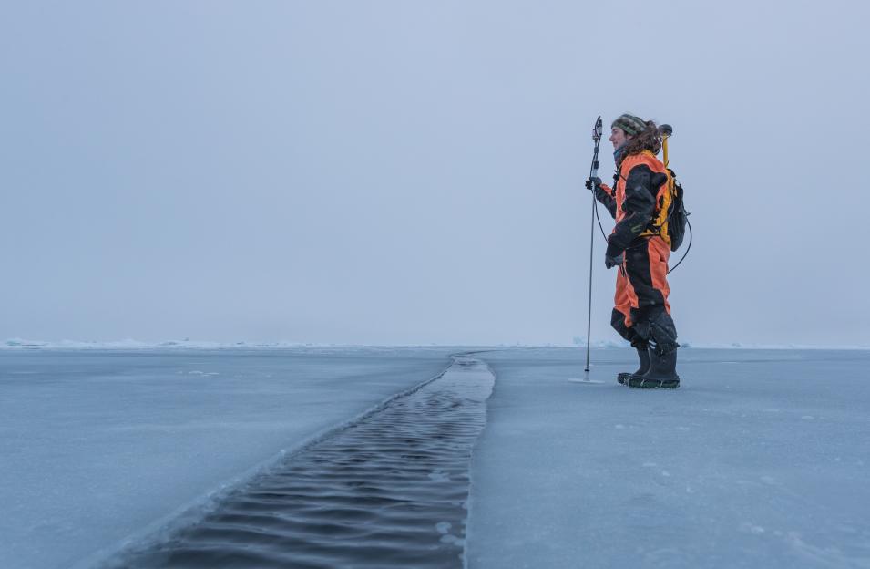
Dr. Melinda Webster stands on young sea ice in the Arctic
Image Caption

Webster measures snow depth distributions using a Magnaprobe (an automated snow depth probe) while wearing a survival suit designed to keep her dry and afloat should she happen to break through the ice. This photo was taken during the MOSAiC expedition in late September (of 2020), just as sea ice was beginning to freeze-up again. The dark colored, snow-free surface of the ice indicates it was recently formed. Photo credit: Lianna Nixon

One such scientist engaged in this work is Webster, Research Assistant Professor at the Geophysical Institute of the University of Alaska Fairbanks and member of NASA's National Snow and Ice Data Center Distributed Active Archive Center (NSIDC DAAC) User Working Group (UWG), whose research includes studies on how the snow on top of sea ice functions within the Arctic’s climate system and how melt ponds, the pools of meltwater that form on the surface of Arctic sea ice, impact sea ice albedo and extent.

For example, one of Webster’s projects focuses on Arctic precipitation and its effect on snow and sea ice. She and her colleagues are identifying and categorizing different types of weather events (i.e., cyclones and polar lows) and studying how they affect snow and sea-ice conditions. In particular, she is interested in which weather events increase the snowpack, which initiate snow melt, and how these events are distributed in space and in time. The outcome of this research will be a database of weather events and surface conditions of the past 42 years. The database will facilitate investigations of the long-term changes in atmosphere-snow-ice interactions related to Arctic sea-ice loss and the warming climate. It will also be useful for assessing climate model output of Arctic weather, snow and sea-ice conditions, and identifying potential areas for model improvement.

In another project, Webster and her colleagues are investigating the relationship between surface roughness, snow and melt pond conditions, and the trafficability of sea ice. This research brings together data from airborne campaigns (e.g., Operation IceBridge), satellite missions (e.g., Ice, Cloud, and land Elevation Satellite-2 (ICESat-2), TerraSAR-X, Sentinel), whaling routes, and ground stations to characterize the conditions needed for low-risk travel over sea ice. According to Webster, the end product from this initiative will have “real-world applications for stakeholders who use sea ice as a platform for travel, including coastal communities as well as industry and the Department of Defense.”

In addition to these endeavors, Webster recently spent approximately five months in the field as part of the Multidisciplinary drifting Observatory for the Study of Arctic Climate (MOSAiC) expedition. This objective of this year-long drift experiment, the largest and most comprehensive Arctic field expedition in history, is to better understand how the components of the region’s climate system (the ocean, the atmosphere, the sea ice, and the Arctic ecosystem) interact throughout an entire year.

Although Webster said she is still processing the data, she refers to the field measurements obtained during the seasonal spring/autumn transitions as a “goldmine of information” from a time of year that generally lacks continuous observations.

“It’s filling in the knowledge gaps,” Webster said. “It’s giving us a more complete picture of the mechanisms that drive changes in surface albedo, the distribution of snow, the rate of sea-ice melt, and the spatio-temporal changes in melt ponds. The suite of field data is incredibly valuable for improving our process-oriented understanding of how surface conditions of sea ice affect and are affected by the atmosphere and ocean.”

Having a better understanding of these processes, will help Webster and her colleagues enhance their representations of these physical processes in climate models and, ultimately, improve the ability to better predict future climate conditions.

To conduct their research, Webster and her colleagues use datasets from a variety of sources, including the NSIDC DAAC, which is part of the Cooperative Institute for Research in Environmental Sciences at the University of Colorado at Boulder. The NSIDC DAAC manages, archives, and distributes the data, tools, and resources in NASA’s Earth Observing System Data and Information System (EOSDIS) collection that pertain to snow and ice processes, particularly in regard to interactions among snow, ice, atmosphere, and the ocean.

Among the NSIDC DAAC datasets Webster uses in her research are measurements of snow depth and sea ice thickness from NASA’s ICESat-2 and the European Space Agency’s (ESA) CryoSat-2 satellites; measurements of snow depth and Arctic sea ice elevation acquired during Operation IceBridge aircraft survey campaigns; Bootstrap Sea Ice Concentrations data (Version 3) from the Scanning Multichannel Microwave Radiometer instrument aboard Nimbus 7 and the Special Sensor Microwave/Imager (SSM/I) and Special Sensor Microwave/Imager and Sounder (SSMIS) aboard the Defense Meteorological Satellite Program's (DMSP) F8, F11, and F13 satellites, and Daily Polar Gridded Brightness Temperatures (Version 5) from DMSP SSM/I-SSMIS.

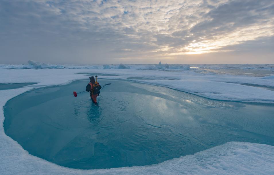
Dr. Melinda Webster wades through a melt pond in the Arctic
Image Caption

Webster wades through a melt pond during the MOSAiC expedition with a snow depth probe modified to measure the depth of melt ponds. Repeat measurements along the same routes on floes provide Webster and her colleagues with a valuable data set that captures the changes in the distributions of snow depth, melt pond depth, and ice thickness over the full annual cycle. Such time-series data are useful for studies of sea-ice mass balance and the freshwater budget of Arctic sea ice, and for relating to satellite measurements. Photo credit: Lianna Nixon

For example, Webster used passive microwave brightness temperature and Bootstrap sea ice concentration datasets from the NSIDC DAAC, along with other data from other sources, in a study on the role of cyclone activity in snow accumulation on Arctic sea ice.

Arctic snow is an important factor in sea-ice mass balance, or the balance of how much the ice grows in the winter and melts in the summer. The high albedo of snow protects the sea-ice surface from solar radiation in spring and summer, while its insulating capacity hinders ice growth in autumn and winter, especially for thinner ice. Therefore, understanding the processes contributing to the seasonal build-up of snow cover is fundamental for interpreting snow’s role in the Arctic sea-ice system.

To better understand those processes, Webster analyzed the role of cyclone activity on the seasonal buildup of snow on Arctic sea ice using model, satellite, and in situ data over a 37-year period (1979–2016). She found that, on average, 44 percent of the variability in monthly snow accumulation was controlled by cyclone snowfall and 29 percent by sea-ice freeze-up. However, Dr. Webster noted strong spatio-temporal differences in Arctic regions. Cyclone snowfall comprised approximately 50 percent of total snowfall in the Pacific compared to 83 percent in the Atlantic. Although cyclones are stronger in the Atlantic, snow accumulation in the Pacific is more sensitive to cyclone strength. These findings highlight the diversity in atmosphere-snow-ice interactions across the Arctic, and emphasize the need for further investigation into the mechanisms governing cyclone activity and its effect on the Arctic snow-ice system in the context of a warming climate.

In another paper published in the Journal of Geophysical Research: Oceans, Webster and her colleagues present a novel approach for calculating snow depth over the entire Arctic Ocean using measurements from NASA’s ICESat-2 and ESA’s CryoSat-2 satellites.

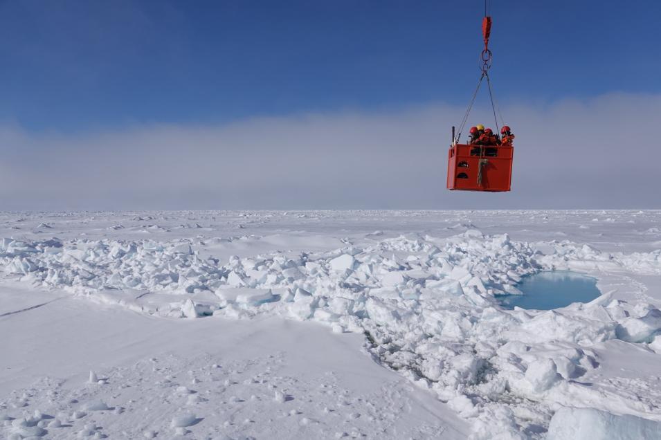
A group of scientists get hoisted back their ship after taking measurements on Arctic sea ice
Image Caption

According to Webster, “When an icebreaker gets stuck in the ice, sometimes it creates an opportunity for science.” In this photo, MOSAiC scientists take measurements of ice thickness, snow, melt ponds, and albedo while waiting for the ice pressure to subside and allow their ship to move. Photo credit: Melinda Webster.

As noted above, the snow layer covering Arctic sea ice plays an important role in the region’s climate. Yet, according to this paper, the current understanding of snow depth is “limited” and “based on field measurements conducted in the middle of last century and from airborne surveys conducted over the last decade.”

The new method combines data from ICESat‐2’s lidar instrument with data from CryoSat‐2’s radar instrument, which measure the heights to the top and bottom of the snow layer, respectively. Differencing the two heights provides an estimate of the thickness of the snow layer.

Although paper indicates the potential of this new approach to measuring snow depth, Webster and her co-authors note that further investigation and analysis, particularly in regard to aspects of data quality, is required. One important data set for evaluating this new approach, Webster and her co-authors say, will be the field data collected by the aforementioned MOSAiC expedition.

In a second paper published in the same journal, Webster and her colleagues use NSIDC and other datasets to examine how snow conditions in the Arctic might change as the climate warms, and how the cascading effects of this change might impact Arctic ecosystems, Arctic sea ice age and extent, and socioeconomic activities in the region.

To conduct this research, Webster performed experiments with two versions of the Community Earth System Model (CESM1-LE and CESM2), a global climate model that provides computer simulations of the Earth's past, present, and future climate states. Then, she evaluated the two models’ spatial and temporal assessments of simulated snow depth by comparing them with monthly snow depth data from in-situ stations and buoys, data on the spatial distributions of snow depth in the western Arctic acquired during Operation IceBridge aircraft survey campaigns, and snow depth distribution data across the entire Arctic basis from NASA’s ICESat‐2 and the ESA’s CryoSat‐2 satellite missions.

Webster’s comparisons showed that the CESM2 model forecast a snow cover that is too uniform and too thin, whereas snow cover from the CESM1‐LE model was heterogeneous and excessively thick. Snow in all model configurations thins in a warming climate, but the 1950–2050 trend in CESM2 model was 75 percent smaller than that in CESM1‐LE owing to the thinner snow cover in CESM2.

Although differences in the mean sea‐ice state and precipitation were the primary factors contributing to the difference in snow conditions between model configurations, these results demonstrate the importance of the strong association among snow, sea‐ice, and atmospheric conditions in the models’ snow depth forecast trends.

Yet, despite the differences in snow condition, the model configurations showed similar seasonal changes in their future projections: earlier, enhanced snow melt in spring, less snow accumulation in summer and early autumn, more sublimation (i.e., the changing of snow into water vapor in the air without first melting into water) year‐round, and slightly more snow‐ice formation. According to Webster, these changes are likely to have important implications for climate feedbacks and the sea‐ice mass budgets in the Arctic.

As these examples illustrate, NASA Earth science datasets are a key component of Webster’s work, as they provide observations of the Arctic that would otherwise be difficult to get.

“NASA’s ability to monitor polar regions year-round, and often in all-sky conditions, is like opening a door to another world,” She says. “We see what’s happening on the surface, we can actually monitor changes on short time-scales, and we can cobble together multi-decadal time-series to reveal some of the drastic changes that are happening on our planet. Without NASA’s Earth science data covering such expansive spatial and temporal scales, we couldn’t do the type of climate science that we do.”

Representative data products used or created:

Available through NSIDC DAAC:

Other data products used:

Read about the Research:

Webster, M.A., DuVivier, A.K., Holland, M.M., & Bailey, D.A. (2020). Snow on arctic sea ice in a warming climate as simulated in CESM. Journal of Geophysical Research: Oceans, 126(1), e2020JC016308. doi:10.1029/2020JC016308

Kwok, R., Kacimi, S., Webster, M.A., Kurtz, N.T. & Petty, A.A. (2020). Arctic snow depth and sea ice thickness from ICESat‐2 and CryoSat‐2 freeboards: A first examination. Journal of Geophysical Research: Oceans, 125(3), e2019JC016008. doi:10.1029/2019JC016008

Webster, M.A., Parker, C., Boisvert, L., et al. (2019). The role of cyclone activity in snow accumulation on Arctic sea ice. Nature Communications, 10, 5285. doi:10.1038/s41467-019-13299-8

Explore more Data User Profiles

Details

Last Updated

Data Center/Project

National Snow and Ice Data Center DAAC (NSIDC DAAC)