Dr. Bridget Seegers

Who uses NASA Earth science data? Dr. Bridget Seegers, for developing new ways to study water quality and track harmful algal blooms.

Dr. Bridget Seegers, Scientist (Oceanographer with the Universities Space Research Association [USRA]), Ocean Ecology Laboratory, NASA's Goddard Space Flight Center

Research interests: Using remotely-sensed satellite data for assessing water quality and harmful algal blooms (HABs) in fresh and salt water.

Research highlights: Dr. Bridget Seegers is searching for a killer. While the killer can’t be seen with the naked eye, it leaves a trail of death and illness that can easily be tracked; it can run, but it can’t hide from the ever-watchful instruments aboard Earth observing satellites. The killer Seegers seeks is cyanobacteria.

Cyanobacteria are microscopic single-celled organisms that live in lakes, streams, oceans, damp soil, and other wet environments. They are photosynthetic, meaning that they are able to use sunlight to produce energy and food. During this process, they release oxygen into the atmosphere. In fact, Earth as we know it today is partly courtesy of the massive amounts of atmospheric oxygen produced by cyanobacteria starting about 3.5 billion years ago (based on the fossil record).

Given the right conditions of water, sunlight, and nutrients, cyanobacteria can multiply rapidly and form extensive “blooms.” These blooms can turn water surfaces a variety of colors depending on the species of cyanobacteria, including green, blue, red, or brown. Cyanobacteria are even capable of moving through layers of water, spending days near the surface collecting sunlight and producing energy then moving deeper at night for nutrients.
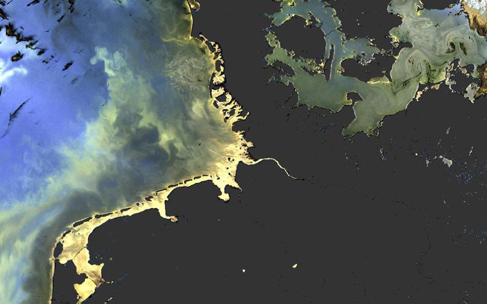
Algal bloom image
Image Caption

Image of blooms in the Baltic Sea acquired July 20, 2016, by the Ocean and Land Colour Instrument (OLCI) aboard the European Space Agency (ESA) Sentinel-3A spacecraft. Blooms appear as swirls of blue/green and yellow; black areas are land. ESA Copernicus Sentinel-3 image.

Some species of cyanobacteria also have the ability to produce toxins that can affect the central nervous system (neurotoxins), the liver (hepatotoxins), and other systems. When these species bloom and produce toxins they create large areas of “harmful algal blooms” or HABs. HABs can be deadly to aquatic life through their toxins and by the decaying blooms using up oxygen in the water. These actions also can impact the well-being of a wide range of non-aquatic species by creating foul odors and contributing to numerous health impacts. In humans, these impacts can include breathing difficulties, rashes, and intestinal problems.

While individual cyanobacteria are microscopic, cyanobacterial blooms can grow large enough and be colorful enough to be detected and tracked using instruments aboard Earth observing satellites. NASA ocean color data are the responsibility of NASA's Ocean Biology Processing Group (OBPG), which supports the collection, processing, calibration, validation, archiving, and distribution of ocean biology-related data products from a number of Earth observing missions. These data are available through the Ocean Biology Distributed Active Archive Center (OB.DAAC), which is the Earth Observing System Data and Information System (EOSDIS) DAAC responsible for archiving and distributing ocean biology data.

CyAN Project logo

Seegers is part of a multi-agency effort called the Cyanobacteria Assessment Network (CyAN) Project. A joint undertaking of NASA, the Environmental Protection Agency (EPA), the National Oceanic and Atmospheric Administration (NOAA), and the U.S. Geological Survey (USGS), CyAN uses historic and current satellite data to detect algal blooms in U.S. freshwater systems. These data are being developed into products designed to create an “early warning system” for detecting cyanobacteria blooms and related water quality issues that threaten ecosystem function, public health, recreational opportunities, and water supplies across the contiguous U.S.

An important aspect of the CyAN Project is its interdisciplinary approach. Along with Seegers (an oceanographer in NASA’s Ocean Ecology Laboratory), the team includes ecologists, public health experts, economists, and remote sensing scientists. The project currently provides weekly estimates of cyanobacteria concentrations for more than 2,000 lakes in the continental U.S. that are large enough to be identified by instruments aboard Earth-orbiting satellites.

Seegers uses data derived from two primary satellite-based instruments to estimate cyanobacteria concentrations: the Medium Resolution Imaging Spectrometer (MERIS), operational 2002 to 2012 aboard the European Space Agency (ESA) Envisat spacecraft; and the Ocean and Land Colour Instrument (OLCI), which is the successor to MERIS and is aboard ESA’s Sentinel-3A spacecraft (launched in February 2016 and currently operational). Use of ESA Copernicus Sentinel data is under agreement between OB.DAAC and European Commission partners.

Lake Okeechobee CI image
Image Caption

Combined OLCI and CI image showing potential HABs in Lake Okeechobee, FL. Red indicates areas of high bloom potential; blue/purple areas have lower bloom potential. Image courtesy of NOAA and derived from ESA Copernicus Sentinel-3 OLCI EUMETSAT data.

Using a NOAA-developed algorithm, OBPG processes MERIS and OLCI data into a derived product called the Cyanobacteria Index (CI), which shows the concentration of cyanobacteria in fresh water bodies and estuaries. This product is provided to the EPA, the USGS, and other end-users. Since the MERIS and OLCI sensor band sets are similar to the sensor band sets on the Moderate Resolution Imaging Spectroradiometer (MODIS) instrument aboard the Terra and Aqua Earth observing satellites, the algorithm can be used to generate similar cyanobacteria concentration products using MODIS data when MERIS and OLCI data are unavailable (as was the case between the end of the Envisat mission in 2012 and the start of Sentinel-3A in 2016). MODIS ocean color data from both Terra and Aqua are available through OB.DAAC.

Water managers across the country are using the CI product to help monitor HABs and provide early indication of potential HAB events, and Seegers points to a few recent success stories. In Oregon, CI data were used to help identify drinking water sources that were potentially susceptible to cyanobacteria blooms, which led to increased monitoring of these areas to help minimize risk to public drinking water supplies. Wyoming issued a recreational use advisory after CI data made managers aware of a cyanobacteria bloom, and Utah’s Department of Environmental Quality routinely uses the product to help monitor the health of state lakes. Twenty-four other states currently are working with the CyAN Project. Any state regulatory agency or health department is welcome to reach out to the CyAN Project to become a collaborator and gain access to CyAN Project data by contacting Dr. Blake Schaeffer at the EPA (schaeffer.blake@epa.gov).

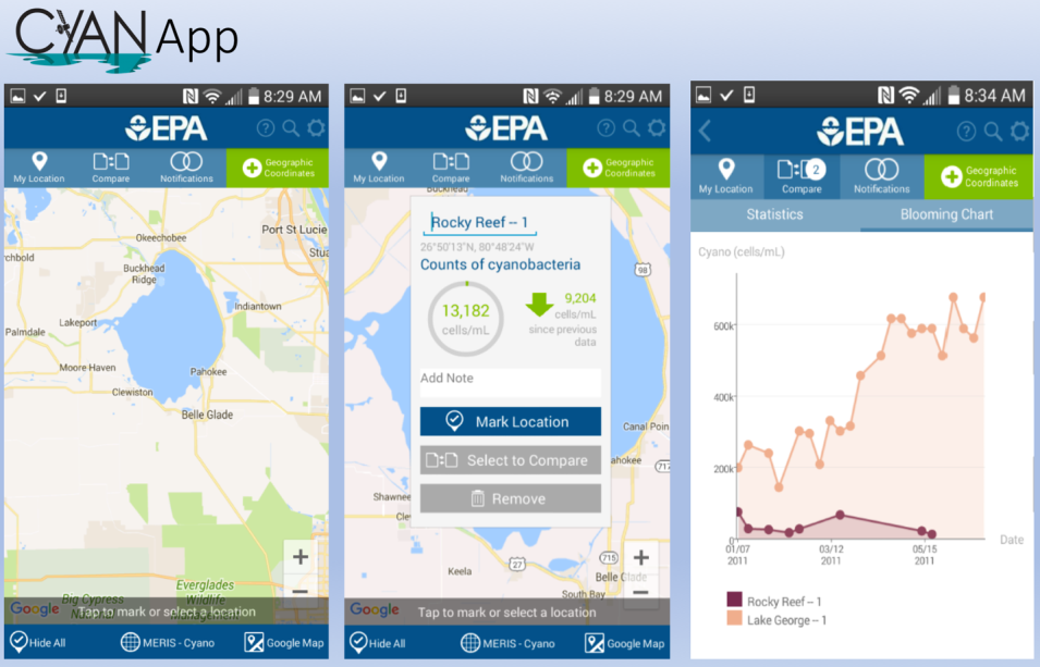
CyAN App
Image Caption

Screenshots from the CyAN app. For more information about this app, please see the Schaeffer, et al. (2018) citation in the Read about the Research section (below).

Another way CyAN Project data are getting into the hands of state health agencies and managers is the CyAN app. Using MERIS and OLCI data coupled with USGS Landsat data, the app enables users to easily make initial water quality assessments and quickly alerts managers to potential problems and emerging threats. The app also includes a data archive that allows users to look back two-to-three years to track changes in cyanobacteria concentrations. While the app currently is available only to U.S. health departments and state environmental departments upon request to the EPA, Seegers notes that it will be available to the general public in the future.

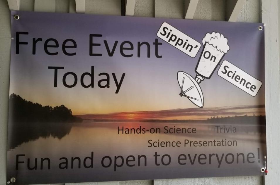
Sippin' On Science

Seegers was instrumental in a recent effort to get NASA Earth science, HAB, and CyAN Project information to the public called “Sippin’ On Science.” These free informal presentations, funded by the Universities Space Research Association (USRA), were conducted at bars and breweries in small towns across Wisconsin and Minnesota over the summer. Along with hands-on science, trivia contests, a demonstration of the CyAN app, and information about lakes, algae, research robots, and satellite science, Seegers brought along a microscope where participants could see samples of microorganisms living in a drop of water from their local lake or river. As Seegers observes, Sippin’ On Science broke down boundaries to create opportunities for the public to learn more about HABs, become better aware of the impact HABs have in their local waterways, and talk with a NASA scientist.

While individual cyanobacteria may be too small to be seen with the naked eye, their blooms can’t hide from instruments aboard Earth observing satellites. Through the use of satellite-based instrument data, Dr. Bridget Seegers and her CyAN Project colleagues are giving health officials, environmental managers, and the general public the timely, accurate information they need to deal with the potentially deadly threat from this microscopic menace.

Representative data products used:

  • Data available through OB.DAAC (the use of ESA Copernicus Sentinel data is under agreement between OB.DAAC and European Commission partners):
  • Landsat Level-2 Surface Temperature Science Product doi:10.5066/F7J38RTH ; available through the USGS

Read about the research:

Schaeffer, B., Bailey, S., Conmy, R., Galvin, M., Ignatius, A., Johnson, J., Keith, D., Lunetta, R., Parmar, R., Stumpf, R., Urquhart, E., Werdell, P. & Wolfe, K. (2018). Mobile device application for monitoring cyanobacteria harmful algal blooms using Sentinel-3 satellite Ocean and Land Colour Instruments. Environmental Modelling & Software, 109(2018): 93-103. doi:10.1016/j.envsoft.2018.08.015

Schaeffer, B., Liames, J., Dwyer, J., Urquhart, E., Salls, W., Rover, J. & Seegers, B. (2018). An initial validation of Landsat 5 and 7 derived surface water temperature for U.S. lakes, reservoirs, and estuaries. International Journal of Remote Sensing, 2018. doi:10.1080/01431161.2018.147545

Seegers, B., Stumpf, R., Schaeffer, B., Loftin, K. & Werdell, P. (2018). Performance metrics for the assessment of satellite data products: an ocean color case study. Optics Express, 26(6): 7404. doi:10.1364/oe.26.007404

Clark, J., Schaeffer, B., Darling, J., Urquhart, E., Johnston, J., Ignatius, A., Myer, M., Loftin, K., Werdell, J. & Stumpf, R. (2017). Satellite monitoring of cyanobacterial harmful algal bloom frequency in recreational waters and drinking water sources. Ecological Indicators, 80(2017): 84-95. doi:10.1016/j.ecolind.2017.04.046

For more information

Explore more Data User Profiles

Details

Last Updated

Data Center/Project

Ocean Biology DAAC (OB.DAAC)