Saharan Dust Versus Atlantic Hurricanes

A unique campaign allows scientists to study the effects of Saharan dust storms on Atlantic hurricane development.

On a typically hot and humid August day, researcher Jason Dunion saw something unusual in the sky over Miami. Dunion said, “It was really humid. It felt like a wet towel outside. But just above us, at 5,000 feet, it was super, super dry. No clouds were forming.” Dunion photographed a layer of dry, dusty air over Miami that had journeyed from the Saharan Desert in northern Africa, some four thousand miles across the Atlantic. Researchers think these dry, dusty air layers from Africa may be a key to understanding why Atlantic atmospheric disturbances, called tropical waves, sometimes intensify into hurricanes, and sometimes fizzle.

Dunion is one of many researchers who want a clearer picture of the genesis and growth of Atlantic tropical storms and hurricanes. Computer storm modeler Cerese Albers, at Florida State University, wants to understand why storms intensify. She said, “We are looking for warning signs about which waves have the potential to form serious storms.

Saharan Air Layer cumulus
Image Caption

NASA and the National Oceanic and Atmospheric Administration (NOAA) teamed up to track the dusty Saharan Air Layer across the Atlantic during the 2006 hurricane season. In this photo, Saharan dust gives the sky an orange glow during a late afternoon sunset in the eastern Caribbean. Small cumulus clouds poke through the tops of the dust layer. A NASA DC-8 aircraft flown out of Cape Verde, Africa, started tracking this dust on September 13, 2006; on September 18, a NOAA P-3 Orion aircraft picked up its trail and captured this photo. (Courtesy Jason Dunion)

If we could understand the life cycle of the disturbance waves, models could better simulate a storm’s potential for intensity and growth over the following few days.” This knowledge could mean better and faster warnings to coastal residents.

Life cycle of a hurricane

Scientists have long understood that convective waves of westward-traveling atmospheric disturbances from the north African coast can be the beginnings of tropical storms and hurricanes. Dunion said, “In the Atlantic, more than half of tropical storms and weak hurricanes, and 85 percent of major hurricanes—categories three, four, and five—come from Africa.” Scientists also know that a number of factors, including sea-surface temperatures, unstable atmosphere, and high water-vapor levels, can cause the waves to intensify and form storms.

Albers and Dunion are among more than one hundred researchers who participated in the NASA African Monsoon Multidisciplinary Analyses (NAMMA) campaign, a joint effort between NASA and the National Oceanic and Atmospheric Administration (NOAA), during the Atlantic hurricane season of 2006. Syed Ismail, a scientist at NASA Langley Research Center, said, “The objective of NAMMA was to see what role the Saharan dust aerosols play in the development of tropical disturbances, which could eventually become hurricanes in the Atlantic. The disturbances propagate from the coast of north Africa, and they get energized in the warm Atlantic climate. And then they sometimes develop into hurricanes.”

The researchers suspected that Saharan dust storms sometimes prevent disturbance waves from intensifying into tropical storms and then hurricanes. That Saharan dust keenly interests Dunion, a research meteorologist from the NOAA Hurricane Research Division in Miami. He said, “The Saharan Air Layer is essentially a huge dust storm that can be the size of the continental United States. Every three to five days during the summertime, these storms roll off of the African coast.” As the dust storms move off northern Africa, convective waves develop farther to the south, pulling moisture up into the atmosphere.

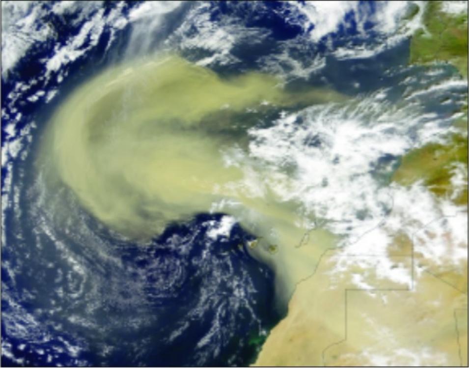
dust storm over Africa
Image Caption

This NASA satellite image shows a dust storm, hundreds of thousands of square miles in size, moving from the Saharan Air Layer over Africa into the eastern Atlantic Ocean. The image was captured by the Moderate Resolution Imaging Spectroradiometer (MODIS) instrument, on the Terra and Aqua satellites, on February 26, 2000. (Courtesy NASA MODIS Rapid Response Team)

“We think a dust storm has three main components that can suppress a hurricane,” Dunion continued. “One, it’s got super-dry air. Hurricanes don’t like dry air in the middle parts of the atmosphere, and that’s exactly what the Saharan Air Layer has. A Saharan dust storm also has a very strong surge of air embedded within it, called the mid-level easterly jet, that can rip a storm apart that’s trying to develop. We call that vertical wind shear. And then the third piece is all this dust.”

Researchers think the dust itself suppresses cloud formation, playing a role in preventing tropical waves from becoming more intense. Ismail said, “We think that dust aerosols can affect tropical disturbances, sometimes even kill those disturbances. Dust inhibits convection, the process of moisture rising to the higher levels of the atmosphere, and then precipitating as rain. So these Saharan dust layers seem to have a blanketing influence on the development of convection.”

Measuring Saharan dust

The NAMMA team planned to gather information that they lacked on the desert dust and tropical wave interactions. Tropical researcher Robert Ross, also at Florida State University, said, “When one of these waves moves out over the ocean, you have very little data unless you have a special experiment like NAMMA. You see the wave when it passes Dakar as it leaves west Africa, you get a few measurements as it passes over the Cape Verde islands, and then there’s a complete data void until you get to the Lesser Antilles. That’s one reason we’ve never been able to understand what’s going on with these waves between Africa and the Caribbean.”

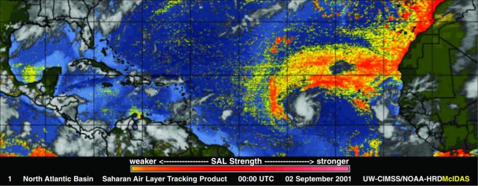
Tropical Depression Erin
Image Caption

Tropical Depression Erin interacts with the Saharan Air Layer (SAL) in the North Atlantic on September 2, 2001. This special infrared imagery from the National Oceanic and Atmospheric Administration’s Geostationary Operational Environmental Satellites shows dry, dusty air (yellow to red shading) from the SAL wrapping into the storm’s circulation. Erin struggled across the Atlantic for the next several days as it became embedded in the SAL, but rapidly intensified into a major hurricane when it separated from the SAL on September 8. (Courtesy Jason Dunion)

Researchers have sought several solutions to this lack of data. They hope someday to use satellite data to continuously track the Saharan Air Layer’s dry air and suspended dust over the Atlantic, but current satellites that possess that technology pass over any given location only occasionally, so they may miss the interaction between the dust storms and developing tropical cyclones. A new aerosol-detecting satellite just launched in April 2006, NASA’s Cloud-Aerosol Lidar and Infrared Pathfinder Satellite Observations (CALIPSO), promises to supply the needed data. Researchers are still calibrating CALIPSO by comparing the satellite data to ground and aircraft-based measurements.

Dunion said, "We were trying to use satellite data to watch how a tropical wave might get embedded in one of these Saharan dust storms. It can really get beat up, it can really get suppressed." Aircraft measurements helped the researchers understand what the new satellite was saying.

"We've been flying the NOAA P-3 and G-IV Hurricane Hunter aircraft out of Barbados to look at these interactions, and now that we have these new satellite eyes to track the dust storms, we can use that information to better target our aircraft flight tracks," Dunion said. Hurricane Hunters fly into storms over the western Atlantic to drop instruments, called Global Positioning System (GPS) dropsondes, through the air layers, then relay meteorological measurements and storm positions to forecasters and researchers. To get the complete picture of storm development, they needed similar data from the eastern Atlantic.

To fill the data void over the eastern Atlantic, researchers turned to the Lidar Atmospheric Sensing Experiment (LASE) instrument. LASE, a relatively new instrument developed by NASA, senses aerosols and water vapor using lasers and can be flown on a DC-8 aircraft right into a study area. NASA planned to fly the instrument from Africa into developing dust storms and tropical disturbances during the 2006 hurricane season, while the NOAA team would pick up the storm over the central and western Atlantic. Dunion said, “NASA was flying their DC-8 with LASE out of Cape Verde while we flew the NOAA P-3 and G-IV Hurricane Hunter planes out of Barbados. They would start tracking a dust storm way out east, then a couple of days later we would pick it up as it came into range of Barbados.”

LASE also provided an essential piece of data that the Hurricane Hunters could not. Dunion said, “While the GPS dropsonde can measure all sorts of things—pressure, temperature, humidity, wind—it can’t measure dust. So that’s a piece of the puzzle we can’t quite get. The LASE is a great tool to fill that gap. It can measure the super dry air in the Saharan Air Layer, and also look at where dust is situated in the vertical profile. It fills in some of the blanks that we haven’t been able to address with our flights over the last couple of years.”

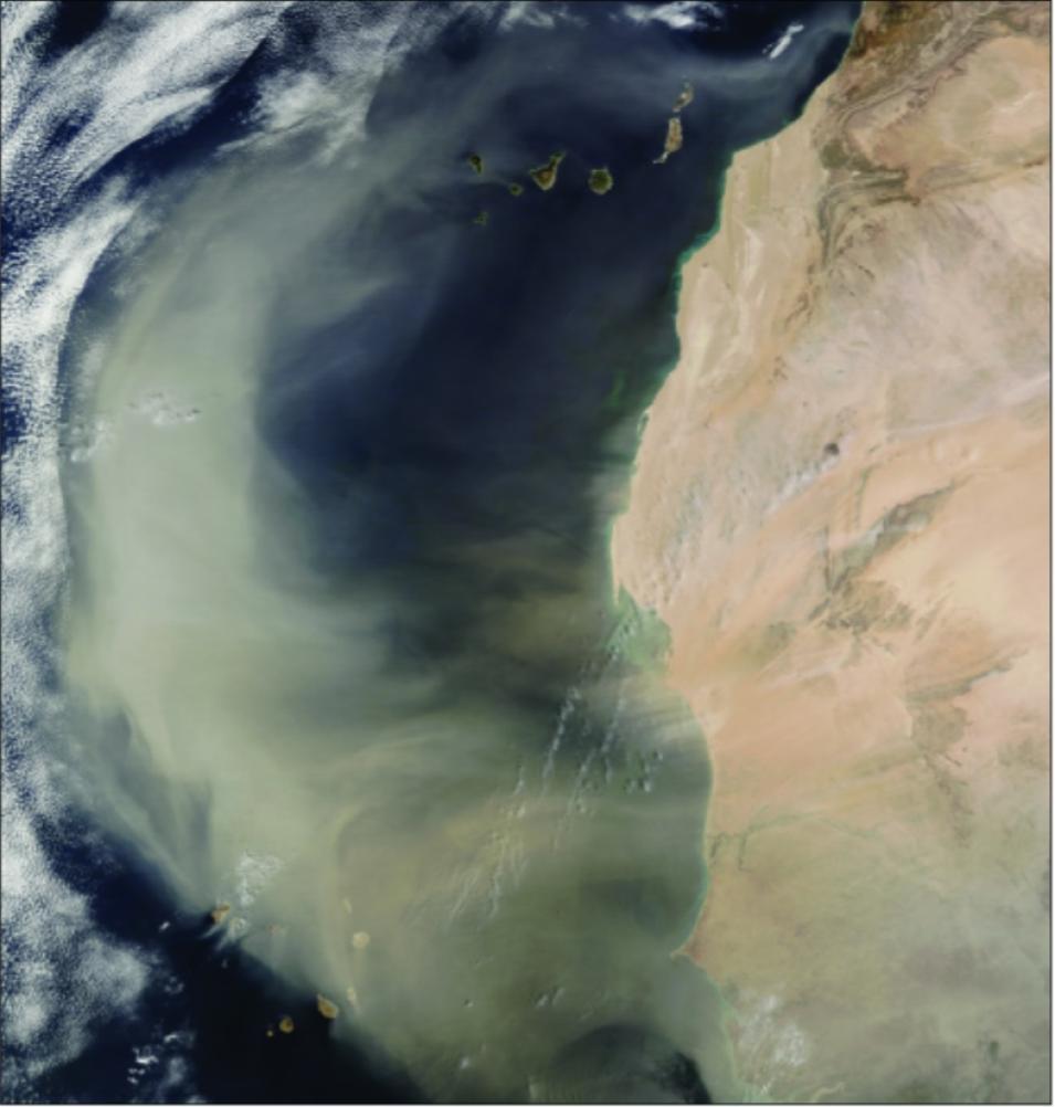
MODIS Saharan Air Layer
Image Caption

The Moderate Resolution Imaging Spectroradiometer (MODIS) instrument, aboard NASA’s Terra and Aqua satellites, captured this image of a Saharan Air Layer outbreak moving off of Africa into the North Atlantic on March 2, 2003. (Courtesy NASA MODIS Rapid Response Team)

The 2006 Atlantic hurricane season

In August 2006, as the hurricane season began, researchers assembled in Cape Verde, Africa, to monitor conditions. As a wave began to develop, the team flew the DC-8 and its LASE instrument into it to capture data. Ismail and the data team retrieved the aerosol and water vapor data from LASE and made it available to researchers on the NAMMA team via the NASA Global Hydrology Research Center, which manages and disseminates the data collected for NAMMA

By scrambling when conditions were right, the NAMMA team successfully captured 2006 storm data with LASE. Ross said, “Seven atmospheric waves moved from Africa out into the Atlantic during the NAMMA experiment. Four ultimately developed into named systems over the Atlantic, three into hurricanes, and one into a tropical storm. The other three did not develop into storms.”

Data from all the cases proved valuable. Dunion said, “We’re learning that when these systems run into the Saharan Air Layer, they consistently struggle, especially if they’re small in size. And positioning and timing is everything.” One wave that NAMMA flew into later became Tropical Storm Debby, in August 2006. 

“That system came off of Africa and curled up into the Saharan Air Layer and got completely embedded inside of it,” Dunion said. “It was starved for moisture, and there were strong winds that helped to bring that dry air in closer to the storm. We learned that systems that are fairly small, like Debby, are vulnerable if they get embedded inside of the Saharan Air Layer.”

But a larger, differently positioned storm proved less vulnerable. Dunion said, “We followed a system a month later that became category three Hurricane Helene, a much bigger system. It moved along the southern edge of the Saharan Air Layer, so it was tapping into moist tropical air down to the south, but north of it there was dry air lapping into it. That storm seemed to be fighting the effects of the dry air, mid-level easterly jet, and dust.”

The NAMMA data also suggested why the 2006 Atlantic hurricane season was below average for the Atlantic, with only two storms making landfall in the United States, both as weaker tropical storms. Ross said, “We think that the 2006 hurricane season in the Atlantic might have been less active because the dry Saharan Air Layer seemed to be unusually strong coming across the Atlantic. Because it persisted in such a strong state as it crossed the ocean, the Saharan dry air and dust may have defeated more disturbance waves from developing into stronger storms.”

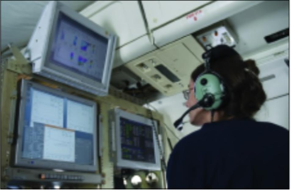
DC-8 LASE instrument
Image Caption

Susan Kool monitors data from the Lidar Atmospheric Sensing Experiment (LASE) instrument aboard a NASA DC-8 aircraft flying through a Saharan dust storm over the Atlantic. Researchers hope to use these data to track interactions between the dust and tropical storms and to better understand Atlantic hurricane development. (Courtesy NAMMA team)

Intense studies of intensity

Much is at stake if researchers can solve the puzzle of Atlantic storm-to-hurricane intensification. Dunion said, “Over the last several decades, we’ve made steady improvement in hurricane track forecasts, but improvements in intensity forecasts have been much slower, almost flat. We need to take every little step we can to try to get the intensity trend moving more like the track trend.” 

For coastal residents and emergency managers, intensity forecasts can be the difference between deciding to make minor storm preparations or to evacuate. More accurate storm intensity forecasts save money, time, and lives for coastal communities.

The NAMMA team continues to sift through the LASE data and the vast array of other observations taken during the campaign, hoping for more insights on Atlantic hurricane development. The researchers see the campaign as a unique event that was a long time coming. 

Dunion said, “Ten years ago we didn’t have a way to track these dust layers. We’ve accidentally flown through and over the tops of the Saharan Air Layer in the past without even knowing it. NAMMA used cutting-edge instruments and technology, and those field experiments help us make these little leaps forward. The idea is to keep that ball rolling.”

References

Dunion, J. P., and C. S. Velden. 2004. The impact of the Saharan Air Layer on Atlantic tropical cyclone activity. Bulletin of the American Meteorological Society 85(3): 353-365.

Kamineni, R., T. N. Krishnamurti, R. A. Ferrare, S. Ismail, and E. V. Browell. 2003. Impact of high resolution water vapor profiles on hurricane forecasts. Geophysical Research Letters 30: 1234.

Kamineni, R., T. N. Krishnamurti, S. Pattnaik, E. V. Browell, S. Ismail, and R. A. Ferrare. 2006. Impact of CAMEX-4 data sets for hurricane forecasts using a global model. Journal of the Atmospheric Sciences 63: 151-174.

NOAA Aircraft Operations Center. Frequently asked questions: What is an easterly wave? http://www.aoml.noaa.gov/hrd/tcfaq/A4.html. Accessed August 2, 2007.

Ross, Robert S., and T. N. Krishnamurti. In press. Low-level African easterly wave activity and its relation to Atlantic tropical cyclogenesis in 2001. Monthly Weather Review.

Wakimoto, R. M., H. V. Murphey, E. V. Browell, and S. Ismail. 2006. The “Triple Point” on 24 May 2002 during IHOP. Part I: Airborne doppler and LASE analyses of the frontal boundaries and convection initiation. Monthly Weather Review 134(1): 231-250.

Wulfmeyer, V., H.-S. Bauer, M. Grzeschik, A. Behrent, F. Vandenberghe, E. V. Browell, S. Ismail, and R. A. Ferrare. 2006. 4-dimensional variational assimilation of water vapor differential absorption lidar data: The first case study within IHOP 2002. Monthly Weather Review 134(1): 209-230.

For more information

NASA Global Hydrometeorology Resource Center Distributed Active Archive Center (GHRC DAAC)

Lidar Atmospheric Sensing Experiment (LASE)

NASA African Monsoon Multidisciplinary Analyses (NAMMA)

Saharan Air Layer Background

About the data
SensorLidar Atmospheric Sensing Experiment (LASE) 
Data setsNASA African Monsoon Multidisciplinary Analyses (NAMMA) Lidar Atmospheric Sensing Experiment (LASE): DC-8 Relative Aerosol Scattering DC-8 Water Vapor Mixing Ratio (Nadir) 
ResolutionDC-8 Relative Aerosol Scattering Vertical: 30 meters Horizontal: Data reporting interval is 6 seconds (1.4 kilometers) with horizontal averaging of 3 seconds (0.7 kilometers) DC-8 Water Vapor Mixing Ratio (Nadir) Vertical: 330 meters with a reporting interval of 30 meters Horizontal: 2 minutes (~28 kilometers) with a sub-sampling (reporting) interval of 6 seconds (1.4 kilometers) 
ParametersAerosol scattering Water vapor mixing ratio 
DAACNASA Global Hydrometeorology Resource Center Distributed Active Archive Center (GHRC DAAC) 

Details

Last Updated

Published

Data Center/Project

Global Hydrometeorology Resource Center DAAC (GHRC DAAC)