Finite Forests

Remote sensing proves ideal for watching rapid changes to Russia's remotest forests.
author-share

The quiet expanses of pine and spruce that sprawl across northern Russia are the largest forests in the world, and the major source of lumber for rapidly growing markets in Asia and Europe. Demand for wood in neighboring countries has encouraged Russian logging operations to move continuously north in search of old-growth trees. While Russia’s supply of trees may seem endless, some forestry experts are concerned that expanded logging will fragment one of the last intact virgin forests in the world.

But determining the extent of forest change is challenging. Russian forests cover an area larger than the contiguous United States. The forests span vast, unpopulated regions with no permanent road system, making it difficult to evaluate forest cover from the ground. So scientists and foresters are now testing new methods to survey forests, using satellite sensors that gather data over broad areas. The data they collect may help Russian foresters sustainably manage timber harvesting in the region.

Clear-cuts expand in virgin forest

Hans-Jürgen Stibig, a researcher who studied forest change in Russia, said, “Russian forests are important in terms of environmental protection, biodiversity, and carbon storage. While tropical forests get a lot of attention, there is strong interest in Europe in promoting the sustainable use of our planet’s boreal forests, especially those of our close neighbor Russia.” Stibig works at the Joint Research Centre (JRC) of the European Commission in Italy, whose goal is to provide research support for environmental policy in Europe.


Image
boreal forest Karelia
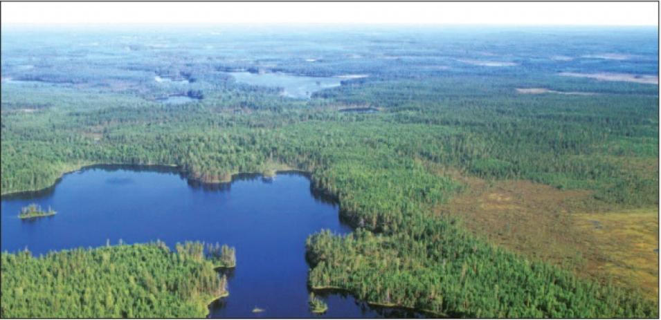
This aerial photograph shows a small section of the sprawling boreal forests in the Karelia Republic, Russia. Much of this mosaic of forests, lakes, rivers, and wetlands, dominated by spruce trees, is virgin forest. However, the region is rapidly changing because of logging. (Courtesy V. Kantor)

Some scientists and policy makers say that logging poses a growing threat to the virgin forests of northern Russia. Clear-cutting, a common method of logging, removes all of the trees in an area, fragmenting intact forests. Lars Laestadius, a researcher at the World Resources Institute and project manager for Global Forest Watch Russia, said, “There are not so many areas left in the world that are close to completely natural. We need these virgin forests, both as a reference area, so we can see how we have impacted other forests, and to preserve biodiversity.” Boreal forests also store carbon that could contribute to climate change if it escaped, whether through forest fires, thawing soils, or forest degradation from extensive logging.

Logging in Russia removes as many as 20,000 square kilometers (8,000 square miles) of trees per year, much of that in previously untouched boreal forest. Clear-cuts account for most of this logging, and while the cut areas eventually regrow, it can take hundreds of years for a boreal forest to reach maturity. “The logging industry in Russia keeps pushing the timber frontier up to the north. The problem is that as you go further north, the trees grow back more slowly,” Laestadius said. Trees grow more slowly in northern regions because less solar radiation reaches the ground in northern latitudes and the growing season is shorter.

The right sensor for the job

Researchers have already used satellites to measure forest cover in tropical rain forests. Using the visual contrast between dark green trees, lighter clear-cuts, croplands, and grasses, scientists can distinguish areas of forest from other land cover types. By collecting data over long periods of time, researchers can figure out how forests are changing.


Image
MODIS clear cut Karelia
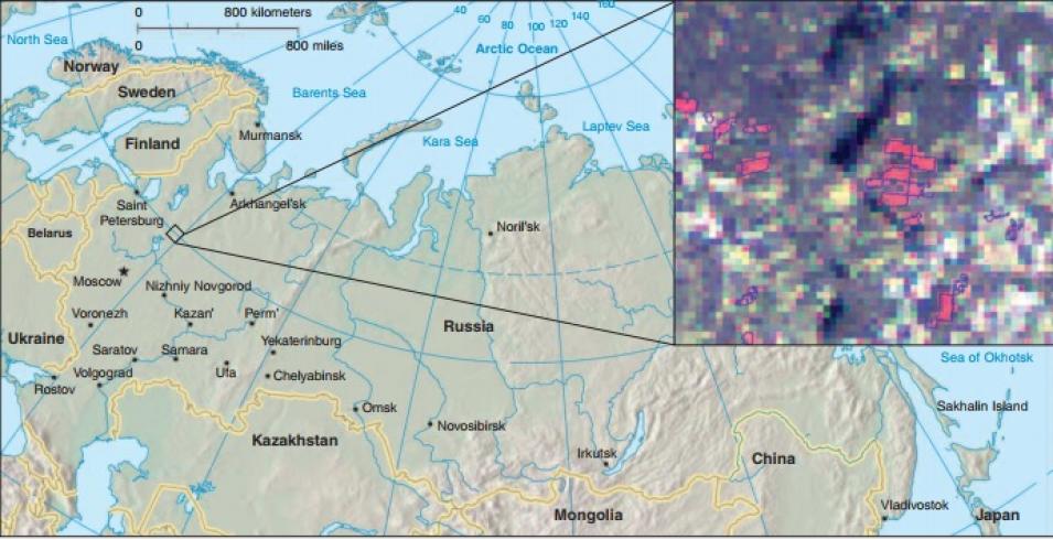
The Moderate Resolution Imaging Spectroradiometer (MODIS) image, inset, upper right, shows clear-cut areas (in red) in the Karelia region of Russia’s boreal forests between 2000 and 2002. MODIS is a medium-resolution sensor that provides broad spatial coverage, yet enough detail to capture relatively small clear-cuts that would otherwise be difficult to observe in vast, remote areas. (Courtesy T. Bucha, H. Stibig, from Remote Sensing of the Environment)

But while tropical forests are well studied, remote sensing studies of Russia’s boreal forests are rare. Because the forests are so expansive, researchers attempting to map entire regions generally use coarse-resolution data that cover thousands of kilometers. However, coarse-resolution sensors cannot pick up smaller changes, such as clear-cuts, which present Russia law limits to fewer than 50 hectares (120 acres), approximately 700 meters by 700 meters (2,300 feet by 2,300 feet). High-resolution sensors can pick out details that escape the coarse-resolution sensors, but cannot easily cover broad areas because the huge volumes of data are difficult to obtain and work with.

To find the right data, Stibig worked with fellow JRC researcher, Tomáš Bucha. They used NASA Moderate Resolution Imaging Spectroradiometer (MODIS) data, available from NASA's Level 1 Atmosphere Archive and Distribution System Distributed Active Archive Center (LAADS DAAC), to see if it could provide the missing link between detail and coverage. Bucha said, “The MODIS sensor is great for studying large geographical areas while providing good detail. We wanted to find out if this medium spatial resolution satellite imagery could support large-scale forest research.”

Stibig and Bucha selected two test sites for their experiment, in the Karelia and Komi Republics of northwestern Russia. Karelia and Komi are home to slender pine and spruce forests that produce lumber destined for northern Europe. The JRC and the Russian Space Research Institute (IKI) had already studied those test sites using high-resolution satellite imagery. In 2002, Global Forest Watch Russia and JRC identified both regions as hot spots of forest cover change. “In these areas the main forest change from humans is due to clear-cuts,” Stibig said.

With a resolution of 250 meters (270 yards), MODIS data were right at the edge of being able to detect clear-cuts; a single MODIS pixel covers 62,500 square meters (74,800 square yards). Most of the logged areas at the two sites were made up of clear-cuts ranging in size from about 100,000 to 500,000 square meters (120,000 to 600,000 square yards), sometimes aggregating to larger logging patterns. Stibig said, “We wanted to see where the limits were. How far could we go with this medium resolution sensor?”


Image
Global Forest Watch Russia
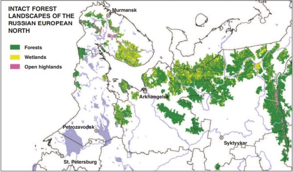
This map, compiled by Global Forest Watch Russia, shows in green the remaining areas of intact forest in northwestern Russia. As logging moves north into these untouched forests, researchers worry that one of the last, large old-growth forests in the world could be lost. (Courtesy International Arctic Research Center)

To distinguish forested areas from clear-cuts, Stibig and Bucha looked for color differences. “In MODIS images, the contrast between coniferous forest and clear-cut is quite strong, so we can spectrally detect this change quite well,” Stibig said. The scientists then designed a computer program to automatically identify clear-cuts. Their method caught 90 percent of clear-cuts larger than 15 hectares (37 acres), and about 60 to 75 percent of clear-cuts between 10 and 15 hectares (25 to 37 acres).

Stibig and Bucha’s study demonstrates that the MODIS data could be useful in large-scale efforts to map change in Russia’s boreal forests. Bucha said, “The objective of this study was to see whether we could estimate forest change for large areas. MODIS data are perfect because they are freely available and easy to get.”

New view of a changing landscape

Stibig and Bucha see their study as a first step in coherently mapping the changes in Russian forest cover. Stibig said, “The idea is to test such forest monitoring approaches in a large area, for example, for all the boreal forests in the northwest of Russia, in collaboration with Russian scientists.” Such efforts could help support sustainable forest management and contribute to climate change research. While both Stibig and Bucha have now moved on to other projects, other researchers are picking up where they left off, expanding the idea to larger areas and combining MODIS with other sensors. The next challenge is to turn these short-term forest research projects into a long-term data series.

Tom Stone, a researcher at the Woods Hole Research Center, said, “Remote sensing is an ideal tool to study Russia. But we need to monitor these areas on a continuing basis. If we have just one date, we can’t say anything about the rate of change.” Mapping Russian forests over time could help researchers understand how changes in the extent of the carbon-rich Russian forests might affect global climate change. “Russia’s forests are the world’s largest, so they are very important in terms of understanding the global carbon cycle,” Stone said. “But we don’t even know whether they are an overall source of carbon dioxide to the atmosphere, or a sink for carbon dioxide coming out of the atmosphere.”

Forestry experts say that such efforts might also help people understand the limits of a seemingly endless resource. To keep the logging industry viable, loggers have to use harvesting methods that keep forests healthy. Laestadius said, “Every country has had the same problem historically. It just depends on when you run into a wall and you see that the resource will run out.”

References

Achard, F., et al. 2006. Areas of rapid forest-cover change in boreal Eurasia. Forest Ecology and Management, 237:1-3, 322−334.

Bartalev, S., A. Belward, D. V. Erchov, and A. S. Isaev. 2003. A new SPOT4-VEGETATION derived land cover map of Northern Eurasia. International Journal of Remote Sensing 24(9): 1977−1982.

Bucha, T., and H. J. Stibig. 2007. Analysis of MODIS imagery for detection of clear-cuts in the boreal forest of northwest Russia. Remote Sensing of the Environment 112: 2416−2429.

Houghton, R. A., et al. 2007. Mapping Russian forest biomass with data from satellites and forest inventories. Environmental Research Letters 2(4), doi:10.1088/1748-9326/2/4/045032.

For more information

NASA Level-1 and Atmosphere Archive and Distribution System Distributed Active Archive Center (LAADS DAAC)

Moderate Resolution Imaging Spectroradiometer (MODIS)

MODIS Rapid Response System

European Commission Joint Research Center institute

Global Forest Watch Russia

Woods Hole Research Center

About the remote sensing data
Satellite Terra
Sensor Moderate Resolution Imaging Spectroradiometer (MODIS)
Data set Level 1B Calibrated Radiances
Resolution 250 and 500 meter
Parameter Surface reflectance
DAAC NASA Level-1 and Atmosphere Archive and Distribution System Distributed Active Archive Center (LAADS DAAC)
Last Updated