Pixel Perfect—GIBS and Worldview Help Lower Barriers for Users of NASA Earth Observing Data

Images provided through the EOSDIS Global Imagery Browse Services (GIBS) along with the Worldview interactive data browser provide a gateway to the initial discovery and analysis of NASA Earth observing data.
author-share

For many people, knowing that an event is occurring is an integral first step in discovering the reasons behind why an event is occurring. For example, you might look outside to conduct a quick visual analysis of the data (it is cloudy and rain is falling) and use this observation to make an initial assessment of what this means – you need an umbrella. When you have more time, you might pull up National Weather Service (NWS) data to see the reasons behind what you observed: that a cold front created a disturbance that led to the rain. Visualized data – seeing rain falling – was your first step in data discovery.

The same is true for users of NASA Earth observing data: turning instrument data into an image of a natural event or sensor output, such as a dust storm or a measurement of atmospheric ozone concentrations, allows scientists and researchers to conduct an initial assessment of the data and make inferences about the potential significance of what they are seeing in the image. After this initial visual assessment, the data behind the image, including more heavily processed science-quality data, can be downloaded for detailed analysis and research.

This all sounds like a simple process, but the sheer amount of NASA Earth observing data makes discovering specific data products or the right data products a challenge. One way NASA addresses this challenge is through visualizations of satellite data that are provided through NASA’s Global Imagery Browse Services (GIBS) that can be browsed and viewed using the Worldview interactive interface.

One important aspect of Worldview is that it is not part of GIBS, but, rather, sits on top of GIBS. This allows people to build their own clients that can retrieve GIBS imagery or to use imagery provided through GIBS in other venues, such as for educational websites, planetarium shows, or environmental forecasting.

Image
EOSDIS_logo
Figure 1: EOSDIS provides end-to-end capabilities for managing NASA’s Earth science data. (Image courtesy of NASA EOSDIS)

Providing innovative ways for scientists, researchers, students, and other users to interact with and discover NASA Earth observing data is an important objective of NASA’s Earth Observing System Data and Information System (EOSDIS) (Figure 1). The EOSDIS currently manages more than 9 Petabytes (PB) of data, which is processed, archived, and disseminated by 12 discipline-specific NASA Distributed Active Archive Centers (DAACs) across the country. Finding specific data products in this vast collection is made easier through data product collections like GIBS and interactive data viewing interfaces like Worldview.

“What we’re doing with GIBS and Worldview is providing a common interface for users to browse visualized data from all disciplines,” explains Ryan Boller, GIBS Project Manager and the Worldview Product Owner. “In some cases, this visualized data is all that some users need.”

Providing Data Products Through GIBS

GIBS provides open access to full resolution data images derived from NASA Earth observing data that are served as pre-configured tiles. These image tiles can be delivered to systems like Worldview rapidly. Since its introduction in 2011, GIBS has proven to be a popular EOSDIS service.

According to EOSDIS metrics, over the two-year period from January 1, 2013 to December 31, 2014, the number of image tiles provided to users through GIBS more than doubled. During December 2014 alone GIBS processed almost 50 million image tile requests.

A key feature of data products available through GIBS is that many of them are available for viewing within four hours after a sensor collects the data thanks to NASA's Land, Atmosphere Near real-time Capability for EOS (LANCE). LANCE provides more than 100 near real-time data products created from data collected from sensors aboard orbiting Earth observing satellites, including NASA’s Aqua, Aura, and Terra satellites and the joint NASA/Japan Aerospace Exploration Agency (JAXA) Global Precipitation Mission (GPM).

“In terms of availability, no one else can provide NASA global Earth observing imagery to the public as fast as we do,” says Boller. “This near real-time aspect is one of our most important and popular features.”

Image
MODIS imagery provided by GIBS projected on Science on a Sphere
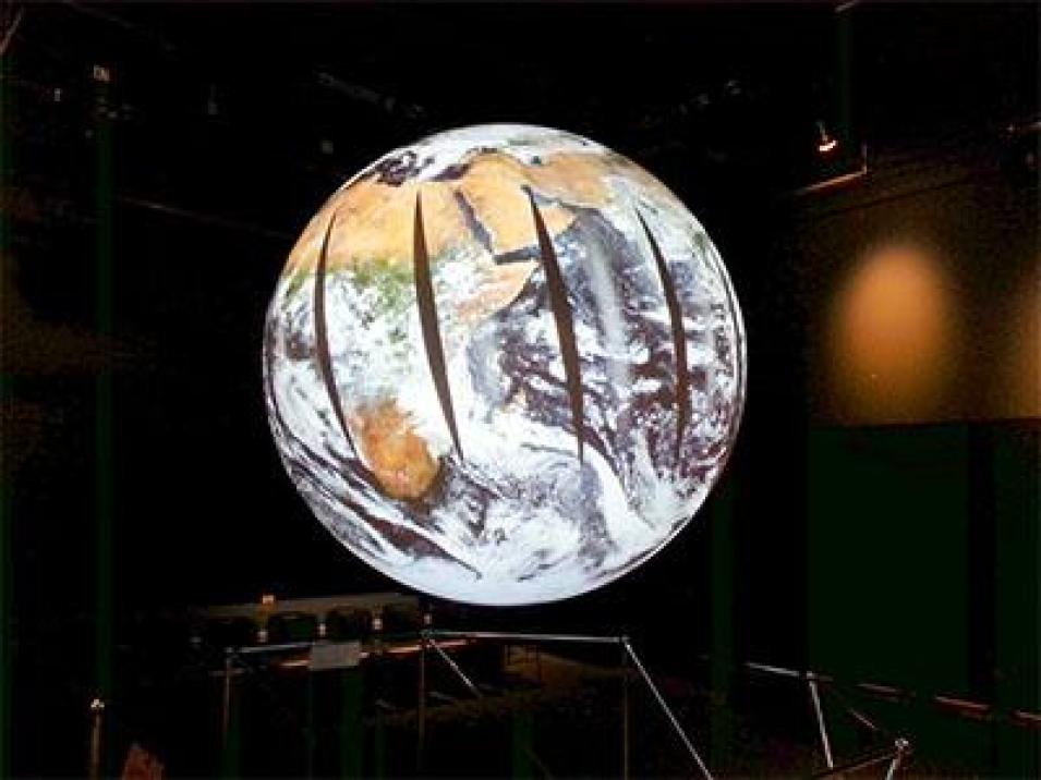
Figure 2: Science on a Sphere® uses computers and video projectors to display GIBS data on a 1.8 meter (6 foot) diameter sphere. (Image courtesy of Ryan Boller)

As noted earlier, Worldview is one client that can access and display GIBS imagery; however, it is not the only client that can display GIBS imagery.

Other clients include the Public Broadcasting Service (PBS), which uses GIBS imagery on its Cloud Lab website and the National Oceanic and Atmospheric Administration (NOAA), which uses GIBS imagery for its Science on a Sphere® presentations (Figure 2). The National Weather Service uses images provided by GIBS to help pinpoint ice accumulations for shipping. The Hayden Planetarium at the Rose Center for Earth and Space at the American Museum of Natural History in New York City even uses GIBS imagery in some of its planetarium shows.

“[The planetarium] directly connected to GIBS to show what the Earth looked like,” explains Boller. “Since they wanted full day imagery, they went to the previous day and said, ‘This is pretty much how the entire Earth looks right now.’ Now, the planetarium is never going to need the underlying data for this example – they only need the imagery and they’re getting it directly from GIBS.”

Interactively Browsing Data Products Using Worldview

The Worldview interactive data interface, created by EOSDIS, allows users to retrieve and explore GIBS products.

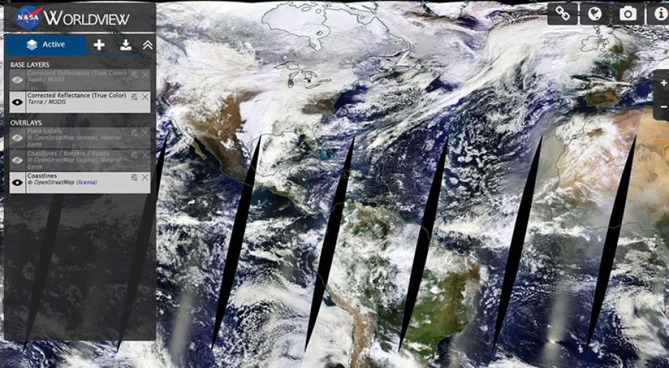
When users access Worldview, they see a true-color base image created from data collected by the MODIS instrument aboard the orbiting Terra and Aqua satellites showing the Earth as it looked within the past few hours (Figure 3). Users can overlay national boundaries on the base image, pan and zoom to any part of the image, use the bottom slider to select a base image from an earlier day or time period, and add layers to analyze a wide range of environmental criteria.

Image
Worldview interface displaying near real-time imagery
Figure 3: The base map on the Worldview home page shows the Earth as it looked within the past few hours of a satellite overflight, including clouds, snow cover, storms, and vegetation. The black gaps in this image are areas not covered by the MODIS instrument aboard the Terra satellite overpass on January 11, 2015. Base images showing the North Pole and Antarctica also are available. The Download Data button is under the “w” in Worldview in the upper left corner of the home page. (Image courtesy of NASA Worldview)

Worldview allows users to rapidly create the data visualizations they need to conduct an initial analysis of environmental data. This, in turn, enables patterns to be discerned easily – such as the counterclockwise signature of a developing tropical storm in the Northern Hemisphere or the wispy brownish streaks that could indicate a dust storm moving out of Africa. While Worldview is not intended to take the place of more heavily processed, science-quality data, it is an efficient first step to guide users toward data they can order from the DAACs for more in-depth research and analysis.

Making GIBS and Worldview Even More Effective for Users

The GIBS and Worldview development teams are hard at work on several enhancements that will make these systems even more valuable to users of NASA Earth observing data products.

One of the most eagerly anticipated developments is the addition of the entire MODIS data record into GIBS. While MODIS data stretches back to 1999 (the launch of NASA’s Terra satellite) and 2002 (the launch of the Aqua satellite), MODIS data in GIBS goes back only to May 2012.

In Worldview, a new Events Feed will enable users to select specific events, such as a hurricane or a dust storm, and immediately jump to visualizations of these events. Boller hopes this new feature will help Worldview users discover other data sets that may assist in their research.

“You may be able to see that the air quality is poor just from looking at our most popular product, which is the corrected reflectance product from MODIS. Visually you can see [in Worldview that] it looks hazy, but we have lots of other products that can give you more detail about why it’s hazy or how hazy it is relative to other parts of the world or other days for a particular area,” he says. “My hope is that this feature will not only show that there’s an event happening somewhere, but that there are numerous data sets available that may be useful for gaining a deeper understanding of the event.”

Image
Cyclone Nilofar as shown in Worldview
Figure 4: Image of Cyclone Nilofar from October 28, 2014, showing GPM Rain Rate and MODIS (Aqua) Corrected Reflectance. (Image courtesy of NASA Worldview)

Of course, new Earth observing missions constantly are being developed and launched, which means new data will be added to the DAACs and find their way to GIBS as new image products. For example, image products from the joint NASA/JAXA GPM mission, which was launched last February, have recently been added to GIBS (Figure 4). The launch of NASA’s Soil Moisture Active/Passive (SMAP) mission in January will lead to a host of new products relating to global soil moisture, crop health, and drought.

To increase the efficiency of GIBS and Worldview, EOSDIS development teams are adding enhancements to make these systems more robust. As Boller notes, GIBS currently handles about 100 products; the new enhancements will enable GIBS to handle thousands of products. As a result, users should expect a dramatic increase in the number of GIBS products over the next year or two.

While Boller is the first to admit that GIBS and Worldview are not perfect systems, he also is clear that the systems are achieving their intended purpose.

“GIBS and Worldview lower the barriers to using our data and I think it enables not just easier use, but also new discoveries to be made and new applications to be developed,” he says.

Useful Websites

GIBS Overview: /gibs
GIBS Code: https://github.com/nasa-gibs
Worldview: https://worldview.earthdata.nasa.gov
Worldview Code: https://github.com/nasa-gibs/worldview

References

NASA Earthdata Wiki. 2015. “Global Imagery Browse Services (GIBS) Home.” https://wiki.earthdata.nasa.gov/display/GIBS/.
Boller, R., et al. “Exposing NASA’s Earth Observations.” PowerPoint presentation at the 2014 FOSS4G Conference, Portland, OR.
NASA EOSDIS. 2015. “Worldview: About.” Worldview website, https://worldview.earthdata.nasa.gov. Accessed January 6, 2015.
NASA EOSDIS. 2015. “Worldview: What’s New in Version 0.7.1.” Worldview website, https://worldview.earthdata.nasa.gov. Accessed January 13, 2015.


Last Updated